Thursday 26 September 2024

St. John's Church in Wadworth - Part 1

 
The Church of St. John the Baptist

Approaching the east end of the Church of St. John the Baptist in Wadworth from Old School Lane, I firstly encountered Wadworth war memorial, which is in the form of a short Celtic cross. It is made with a dark grey rough hewn granite, with a polished panel into which the names of the fallen are inscribed, which I think is probably the Rubislaw variety from Aberdeen.
 
Wadworth war memorial
 
The east wall of the chancel, which I think dates to the C12, is built with coursed rubble walling, where the individual irregularly shaped stones are thinly bedded and cream/buff to yellow in colour, with the very occasionally reddened stone. This is very similar to the dolomitic limestone that I had seen in vernacular architecture in the village and I presume that this has been quarried locally from the Brotherton Formation. 
 
The east wall of the chancel
 
It contrasts with the massive pale cream limestone with a grey patina, which has been used for the quoins and for the c.1300 Y-tracery and dressings of the window. The upper part of the wall has been altered, with very large blocks of yellowish limestone ashlar masonry being used for this. 
 
A detail of the masonry to the east wall of the chancel
 
The south chapel, which according to Pevsner was built a generation later and has unusually tall mullions and tracery with mouchettes, is built in limestone that is similar to the dressings on the east wall of the chancel, but contains a high proportion of thinly bedded stones. 
 
The east end of the south chapel
 
The masonry to the east end of the south chapel is very uniform in colour and, although the thinner beds are not typical of the stone obtained from it, this is very probably from the Cadeby Formation, which has been quarried extensively at Warmsworth and along the Don Gorge to the north-west and Stainton to the south. 
 
Quarries on the Cadeby Formation in the vicinity of Wadworth
 
Set against the wall of the south chapel are a few Coal Measures sandstone headstones, one of which has eroded away to reveal a greyish coloured body of the sandstone, but I was more interested in the pattern of weathering to the inscription and the surrounding stone. 
 
Weathering of a Coal Measures sandstone headstone
 
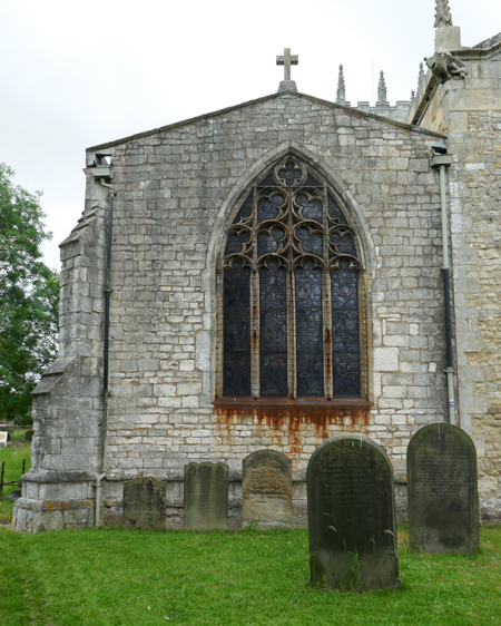
The north chapel is dated to c.1300 addition, with the roughly coursed rubble masonry being similar to the chancel, but the quoins and northern part of the east end is built with much larger blocks of squared greyish limestone blocks, which are similar to those seen in the south chapel.
 
The east end of the south chapel
 
When I visited St. John’s church very briefly back in 2007, when undertaking surveys for the Doncaster Geodiversity Assessment, I was very impressed by the grotesques and, before continuing my walk anti-clockwise around its exterior, I took a few photographs of these. 
 
Grotesques on the chancel
 
Standing back to photograph the north elevation, the colour high level ashlar masonry to the chancel looks incongruous, compared to the rest of the stonework, and I suspect that this may be part of a programme of recent essential restoration. It contains a flat headed window with Tudor style four centred arches to the lights, which fits in with C15 phase of the building mentioned by Historic England, but it looks very different to the masonry on the north side of the clerestory. 
 
The north elevation
 
Although Pevsner mentions that the Norman church had a north aisle, neither he or Historic England make any specific reference to the exterior; however, looking at the size and shape of the blocks, the masonry looks more similar to the north (c.1300) and south (early to mid C14) chapels than the east wall of the chancel.
 
The north elevation of the tower
 
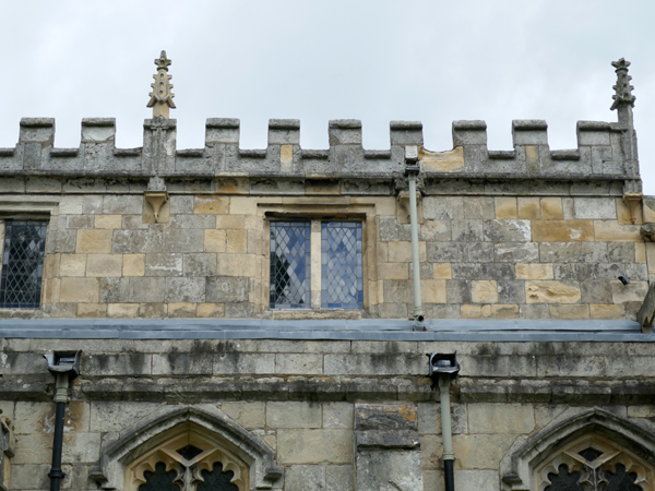
Furthermore, the stonework of the nave comprises poorly coursed rubble, with the pattern changing to squared and coursed masonry above it when the clerestory was added in the late C15, together with the castellated parapets and crocketted finials, which coincided with the building of the tower with limestone ashlar in the Perpendicular Gothic style. 
 
The tower
 
On both the north and south sides of the tower, just above the aisle roofs, sections of masonry remain from the original tower and above these are old rooflines, projecting angled bands of masonry and corbels, which presumably relate to the chambers that are said by Pevsner to have formerly existed above the aisles. 
 
An old roofline and corbels

Moving round to the south elevation, the south aisle to the west of the porch is built with poorly coursed masonry in the lowest section, but the upper part is squared and coursed, with a lancet window that is typical of the Early English Gothic style. 
 
The west end of the south aisle
 
Continuing beyond the south porch, the south aisle is built with ashlar walling that has uniformly sized blocks and windows that have wide triangular arches, which are on the verge of being four centred and have foiled heads to the lights. 
 
A detail of the south aisle window heads and the clerestory
 
Unlike the north elevation, where coursed rubble walling comprises the lower part, the clerestory is built entirely of ashlar masonry that has a similar block size and pattern to the aisle below. All of the limestone used for the ashlar to the tower and other Perpendicular Gothic elements are uniformly grey, yet the south side of the clerestory has a high proportion of cream/yellow coloured blocks, which may be evidence of modern restoration.
 
The south aisle and the south chapel


Wednesday 25 September 2024

A Brief Exploration of Wadworth

 
The village sign in Wadworth
 
Following on from my day out to Anston, I took advantage of the coffee morning that is held on the last Saturday of the month at the Church of St. John the Baptist at Wadworth in Doncaster, which I had very briefly visited when undertaking surveys for the Doncaster Geodiversity Assessment. 
 

The geology around Wadworth  © BGS


Catching what was then the hourly No. 22 bus from Doncaster, the A60 road crosses the red marl of the Edlington Formation before rising up to Main Street in the old part of the village, which is set on the edge of the Brotherton Formation. 
 
Buildings at the junction of Main Street and Walnut Street Hill
 
Alighting at the Main Street/Ratten Row stop, I firstly photographed the group of buildings at the junction of Main Street and Walnut Tree Hill, where the front elevations are built with yellowish roughly squared and coursed limestone walling that, as seen from a distance, appear to be built with quite massive blocks. 
 
The Main Street elevation

On the Main Street elevation, however, the lower section of the walling is built with rubble walling where the limestone is very thinly bedded, which is highlighted by differential weathering. In places, the walling is built directly on very large irregular blocks of massive limestone containing well defined cross-laminations, which I think is bedrock. 
 
Massive limestone forming foundations of the walling on Main Street
 
Where the path slopes away to the north, this is underlain by what is obviously very thinly bedded limestone, which is disintegrating to such an extent that it has been partly rendered and sand and cement has been used to fill in the joints of the larger blocks. 
 
Thin bedded limestone foundations and sand and cement rendering
 
The sample that I collected has a bed height of 3 cm, is buff coloured and very finely crystalline, with a cellular texture where the pores are lined with a black substance that, in the limestones of the Cadeby Formation, are considered to be a manganese oxide.
 
A sample of limestone from the Brotherton Formation
 
Retracing my steps along Main Street, Nos. 1-5 are built out of cream/buff/yellow limestone, which have generally thinner courses than the above buildings. In my previous post, when describing the quarries that I encountered when undertaking the Doncaster Geodiversity Assessment, beds of this height do occur in the Brotherton Formation, but they constitute a minor component of the beds seen in the quarry faces. 
 
Nos. 1-5 Main Street
 
Walking up Old School Lane towards the church, the return wall of No.5 Main Street have obvious lamination that is not usually seen in limestone from the Cadeby Formation, as does the adjacent boundary wall. Looking at the 1901 Ordnance Survey map, where the buildings shown essentially coincide with those now in the Wadworth Conservation Area, three quarries are marked at the edge of the villages, which could have suppied stone for the older buildings in the village. 
 
The 1901 Ordnance Survey map
 
Further up School Street, Wadworth Village Hall (1840) and the old school house on the opposite side of the road are built using very well squared and coursed cream coloured limestone, which looks typical of the building stone obtained from the Cadeby Formation. 
 
Wadworth Village Hall and the old school house
 
Arriving at St. John’s church, which I will describe in my next Language of Stone Blog post, I unexpectedly got the opportunity to visit St. Katherine’s church in Loversall, which was open for a Romanian Orthodox church service, and I was therefore unable to explore Carr Lane at the east end of Wadworth – where I wanted to photograph various old farm buildings for the British Listed Buildings Photo Challenge. 
 
Listed buildings in Wadworth
 
I instead made my way to Wadworth Hall where, after a local had asked me why I was taking photographs of ‘private’ property, I explained that I was allowed by law to do so from the street and took a few quick snaps of the west and east lodges, the house and the gatepiers. 
 
Wadworth Hall and the associated lodges and entrance gatepiers
 
Making my way back through St. John’s churchyard to Main Street, I continued down the hill, where I noticed that the boundary wall on the corner of High Street incorporates very large blocks of limestone, before walking along the A60 to Loversall.
 
Large blocks of limestone incorporated into a boundary wall

Sunday 22 September 2024

The Brotherton Formation in Doncaster

 
A detail of an old quarry face in The Dell

When leading the Sheffield U3A Geology Group field trip to Anston in June 2023, I essentially shared my knowledge of visiting Anston Stones Wood many times and my professional experence of more than 25 years spent surveying very many geological sites on the Permian Cadeby Formation and innumerable historic buildings that are built from this dolomitic limestone – from Aberford in the north to Mansfield in the south, where it is classified as a dolomitic sandstone.
 
The outcrop of the Brotherton Formation in Doncaster
 
Starting with my survey of the potential RIGS (Regionally Important Geological Sites) in Doncaster back in 1997 and the resurvey of these in 2007, when undertaking the Doncaster Geodiversity Assessment, I visited 3 sites on the Brotherton Formation – Skelbrooke quarry, Leys Hill quarries and The Dell quarry garden at Hexthorpe Flatts – and I also saw a small outcrop along Bubup Hill in Loversall, which was not on my list of sites to be surveyed, in addition to seeing it in the cutting when travelling by train from Rotherham to Doncaster
 
An extract from the geological memoir
 
The geological memoir for Goole, Doncaster and the Isle of Axholme says very little about the Brotherton Formation as seen at outcrop, mentioning that “Where exposed, mainly in old small quarries, the limestone is cream, yellow or buff, thin bedded and flaggy, commonly with grey and some red mudstone partings”. 
 
The BGS report on the Cadeby Formation
 
The British Geological Survey internal report (2005) on the building limestones of the Upper Permian Cadeby Formation further adds that “it generally only forms thin and very thin beds rendering it unsuitable for dimension stone. Locally it is used for walling and buildings along the outcrop, especially around Brotherton where it is currently worked for lime and building stone.” 
 
A view of the Skelbrooke quarry in 1997

When undertaking brief surveys of the quarries mentioned above, I didn’t spent any time looking for vernacular architecture in the vicinity but, even when looking at the quarry face from a distance at Skelbrooke quarry, I could see that the limestone was generally thin bedded and it was more suited to making lime or used as aggregates and industrial processes and not for building. 
 
A view of Skelbrooke quarry in 2007

At Leys Hill quarries near Brodsworth, most of the rock faces that I saw were dominated by very thinly bedded limestone that wouldn't even be suitable for dry stone walls, but in places the beds are thick enough to be used as coursed rubble for farm buildings and cottages in the vicinity. 
 
An old quarry face at Leys Hill
 
At Hexthorpe Flatts, the old quarry was transformed into a public park known as The Dell, which is now a Grade II Listed Park and I was able to get close to a bed of quite massive limestone that has a thickness of 20 cm and appears to possess physical qualities that would make it suitable as a general walling stone. 
 
An old quarry face in The Dell
 
During my travels in the previous year, I had been to Cusworth, Warmsworth and Sprotbrough, which are set on the Brotherton Formation and where all of the principal buildings - Cusworth Hall, Warmsworth Hall and St. Mary’s church - are built with limestone ashlar from the Cadeby Formation; however, if local quarries also had beds of 20 cm, I can’t see why these wouldn’t have been used in at least some of the agricultural buildings and cottages.
 
A detail of the old quarry face in The Dell
 
That said, in Warmsworth and Sprotbrough, which are also very near to quarries in the Cadeby Formation, I noticed that many of the cottages are rendered, which is not characteristic of settlements on the Cadeby Formation. This may reflect the fact that these buildings are built with poor quality thinly bedded limestone from the Brotherton Formation, with render applied to provide strength and durability.
 
An exposure of the Brotherton Formation on Bubup Hill in Loversall

Saturday 21 September 2024

A Geology Field Trip in Anston

 
A bryozoan reef at Penny Piece Place
 
Just over a week after my visit to Hooton Roberts, where I had a look at the interior of St. John the Baptist’s church and the reddened sandstones on Crooked Lane and Holmes Lane, I returned to Rotherham to lead a field trip to Anston Stones Wood with the Sheffield U3A Geology Group. 
 
The Anston Stones Wood Geological Trail
 
Having described several previous visits to this spectacular limestone gorge in this Language of Stone Blog, including the recce for this walk which was described in two parts on 9th and 10th October 2024, there isn’t too much more to add about its geology. 
 
The Anston Stones Wood Geological Trail
 
Using the now out of print Anston Stones Wood Geological Trail, which had been produced by the South Yorkshire RIGS (Regionally Important Geological Sites) Group more than 20 years previously, the group had undertaken previous field trips that also entailed a visit to Lindrick Dale to fill the day but, of the 10 other members who turned up on a beautiful sunny day, only 2 had visited this very popular site before. 
 
The Little Stones
 
Setting off from the Anston Parish Council car park, we firstly encountered the Little Stones, which are small outcrops of reef limestone in the Permian Cadeby Formation, before stopping at Dead Man’s Cave, which is perched at the edge of the north side of the gorge. 
 
The Cut
 
During the summer, the wood is extremely lush and the canopy of trees along The Cut was particularly thick after a very wet first half of the year and the general consensus of the group was that they couldn't recall a place in England that looked so green. Furthermore, everyone was surprised to see how the trees had colonised the extensive limestone outcrops, with their roots deeply embedded in the joints of the limestone. 
 
The Cut

Continuing past the old lime kilns, we dropped down to the meandering Anston Brook, where the narrow steep sided gorge expands into a much wider valley. Here, we stopped to have a good look at the excellent information board, which describes the various flora that makes this biological Site of Special Scientific Interest (SSSI) important in South Yorkshire. 
 
An information board
 
At the railway bridge, where the skew arch is built of Staffordshire Blue engineering bricks, we had the advantage of one of our members being a retired civil engineer, who was able to give us a very detailed explanation of this. 
 
The railway bridge
 
Heading back along the gorge on its south side, which was a new experience for all of the group, the only rock exposure that we had an opportunity to examine closely was a section of vertical crags, where undercutting of the thinly bedded limestone at the base has been differentially weathered to leave an overhang. 
 
Undercutting in a limestone crag
 
The main point of interest here is the development of flowstone and a large block of limestone that has become detached from the rock face, but is now connected to the principal rock outcrop by a stalactitic growth of calcite. 
 
Examining stalactitic growth on a fallen block

As very often happens when leading the group, I didn’t have the opportunities to make a full photographic of the day and, having returned to the car park to have our lunch, we had a wander around North Anston to look at the historic architecture in the North Anston Conservation Area and the remains of the quarry face in Greenlands Park. 
 
A bryozoan reef
 
Making our way down to Penny Piece Place to look at the magnificent examples of bryozoan reefs, which form part of Clark’s Stones, we were invited by the owners of the house to come into their garden and have a closer look. From here, we retraced our steps back to the centre of the Conservation Area and, after looking at the spring on The Wells, we returned to the car park after another good day out.
 
A bryozoan reef