When undertaking initial research into the “Let’s talk about the stones” walk for the Friends of Moorgate Cemetery, I came across a brief news report on the Sheffield Area Geology Trust (SAGT) website, dated 14th January 2023, to say that a very unusual ‘omelette’ structure had been found by members during a survey late in the previous year.
I had long since detached myself from any formal involvement with geological conservation in Rotherham, because the Rotherham MBC planning section wanted me to continue providing my professional services for free, when they now had a statutory responsibility for this. I wasn't happy with this, especially since Doncaster MBC and the British Geological Survey had arranged for me to be well paid to resurvey the RIGS in Doncaster for the Doncaster Geodiversity Assessment, which formed an integral part of the Local Development Framework.
A majority decision by the remaining active members of the South Yorkshire RIGS (Regionally Important Geological Sites) Group, now deceased, agreed for it to be absorbed into SAGT and I was briefly a member of their Rotherham Local Geological Sites Panel; however, as the principal surveyor, chairman and publicist for the South Yorkshire RIGS Group, I didn't appreciate being effectively sidelined and I soon lost interest in their activities.
Nevertheless, as a geologist I was genuinely interested to be informed that these very rare ‘omelette’ and other soft sediment deformation structures had been discovered here. This was believed to be the result of a sudden flood and I went to have a look for myself.
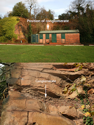
The article states that SAGT are trying to determine if there is further evidence for this sudden flood hypothesis and I wanted to pass on some knowledge that might help them with this. Back in 1994, when I first became aware of the RIGS initiative, and later in 1996 while surveying potential RIGS in South Yorkshire, evidence of this was clearly visible behind the bowls pavilion.
Here, in the exposed rock face, in addition to the scattering of clay ironstone nodules, which are common in the Rotherham Red sandstone – a locally distinctive variety of the Mexborough Rock - there is a bed of conglomerate over 20 cm thick that is composed of these rounded nodules and was presumably laid down in a flood event.
Although the old quarry face had started to become quite overgrown in places, the conglomerate was still clearly visible in March 2010 and December 2011 but, during subsequent visits in 2016, 2018, 2021 and 2023, this was obscured by vegetation.
Further indirect evidence of a flood event recorded in the Rotherham Red sandstone at Boston Park is in the slabs of sandstone used to line a walkway, which contain numerous large Carboniferous plant fossils that formed in a log jam. These slabs would not have been suitable for building stone and were set aside, but unfortunately it is not known where in the quarry face these came from.
As part of my original survey of potential RIGS sites back in 1996, I also saw good exposures of the Mexborough Rock in Darfield Quarry, 13 km to the north of Boston Park, where the formation has a light brown colour that is typical of most Coal Measures sandstones in the region, but also contains a significant contaent of clay ironstone nodules.
Although my photo of it has unfortunately become mislaid in my collection of over 4000 colour transparencies, a conglomeratic bed of similar thickness can be seen in Darfield quarry, which I visited again with my next door neighbour Dan - who played in the quarry as a boy - a couple of months after my last visit to Boston Park.
Having had dealings with the manager of Green Spaces in Rotherham several times over the years, I spoke to him about whether or not it would be possible to clean the section of the quarry face with the exposure of conglomerate. Rotherham MBC have no plans to do this, but it was suggested that SAGT might want to do this themselves


No comments:
Post a Comment