 |
| The Hunloake Arms Inn |
For the first four months of 2023, my trips had been mainly confined to Sheffield, Rotherham and Doncaster and, except for a recce at Creswell Crags with Dave of the Sheffield U3A Geology Group, I had spent no more than half a day out on my travels.
 |
| The location of Treeton in relation to Wingerworth |
The weather started to improve considerably in May and, a couple of weeks after my brief walk around Warmsworth old village, I decided to continue my exploration of the mediaeval churches of South Yorkshire and surrounding counties by visiting All Saints church at Wingerworth, just to the south of Chesterfield in Derbyshire – a distance of just over 20 km from Treeton as the crow flies, but requiring 3 bus journeys to get there.
 |
| Listed buildings in Wingerworth |
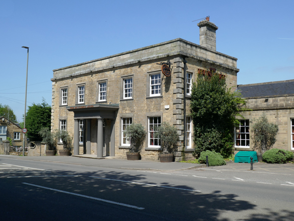
As usual, I had prepared a route based on the British Listed Buildings Photo Challenge, which had identified 11 buildings that would involve a 5 km circular walk, starting at Derby Road. Alighting from The Comet bus at the Hunloke Arms stop, the first building on my list to photograph was the late C18 Hunloke Arms Inn itself, which was built as a house.
 |
| The Hunloke Arms Inn |
Wingerworth is underlain by the Deep Hard Rock, with the Building Stones Database of England map explorer referring to Birdholme Quarry, 1.8 km to the north, as probably being the main source of stone for the now demolished Wingerworth Hall, with Sutcliffe Wood Quarry 1 km to the SW possibly being another source. It is therefore likely that the light brown sandstone for the walling at the Hunloke Arms is the same stone, with the lighter coloured quoins and dressings being from the Millstone Grit, but I didn’t look closely at the stonework.

After photographing a milepost on Derby Road, I made my way up the public footpath to the Wingerworth Hall Estate Road, where I discretely took a few quick snaps of the unlisted former stable block, which has now been converted into several residences.
 |
| Views of the old stable block |
From my photos, I can see that that massive sandstone ashlar, which is presumably the Deep Hard Rock, is distinctly orange coloured in places and reflects the high iron content of much of upper parts of the Pennine Lower Coal Measures Formation (PLCMF) in north-east Derbyshire and South Yorkshire, which was once extensively worked for its ironstone.
 |
| The former service wing to Wingerworth Hall |
I continued a short distance up the private road to photograph the Grade II Listed former service wing to Wingerworth Hall, now converted into flats, which the Historic England describes as being built with Coal Measures sandstone with Millstone Grit dressings – as seen at the Hunloke Arms.
 |
| A house and outbuilding on Longedge Lane |
Retracing my steps to Longedge Lane, I carried on past another house and outbuilding that I presume is part of the old riding school that is marked on the 1883 edition of the Ordnance Survey map, which are built with the same sandstone.
 |
| No. 1 Hockley Lane |
The same sandstone is again used at the mid C19 No. 1 Hockley Lane, which is a former lodge to Wingerworth Hall and Wingerworth Deer Park which, except for its west end with ponds, has now largely been developed for housing.
 |
| A panoramic view from Longedge Lane |
Continuing westward along Longedge Lane up the dip slope of the Deep Hard Rock, I reached edge of the escarpment and took a few photos of the scarp and vale topography to the north-west, which is formed by PLCMF strata.
 |
| Views of flaggy sandstone on Longedge Lane |
Walking down the escarpment, I noticed that flaggy sandstone, placed at an angle, provides support to the banks adjacent to the paths. Flaggy and more massive sandstones have been used in the old boundary wall to Wingerworth Deer Park, with this being reused for the entrances to the C20 houses that have been built along the road.
 |
| Nos. 238-240 Longedge Lane |
I carried on for a few hundred metres past further boundary walls, constructed with flaggy sandstone and more massive sandstone for the coping stones, but I didn’t stop until I reached Nos. 238-240 Longedge Lane – a pair of mid to late C19 semi-detached houses that are built in the Vernacular Revival style.
 |
| An old farm building on New Road inhabited by masonry bees |
Arriving at the junction with New Road, I decided not to go and investigate the road bridge and sheepwash on Hill Houses Lane, which had already been photographed, and instead headed south and briefly stopped to look at an old farm building, where the mortar has been extensively excavated by masonry bees.
 |
| Entrances to nests formed by masonry bees |
On New Road, some of the boundary walls are built with a flaggy sandstone that looks very much like the Greenmoor/Brincliffe Edge Rock in Sheffield and, looking at the geological memoir, the nearby Wingfield Flags – a merger of the Greenmoor Rock and Grenoside Sandstone of the Sheffield district - was widely exploited as a building stone.
 |
| A Wingfield Flags wall with massive sandstone coping stones |
The last buildings on my list to photograph were Nos. 35 and 37 New Road (1794), the former lodges that flank the entrance to the Wingerworth Hall Estate, together with the entrance gatepiers and attached walls.
 |
| The lodges and gatepiers on New Road |
I then made my way down Central Drive past Wall Pond, one of many fish ponds that once existed in Wingerworth Deer Park, seeing only C20 houses until I reached Hockley Lane, where I took another photo of No. 1 before continuing to All Saints church.
 |
| Wall Pond |
No comments:
Post a Comment