Although not a very inspiring walk, it didn’t take me long to get from to Loversall from Wadworth, where I had briefly looked at some of its historic architecture while taking advantage of the coffee morning at the Church of St. John the Baptist, when Rev. Canon Ian Smith had made arrangements for me to visit St. Katherine’s church.
Bearing right to Wadworth Hill off the main A60 road, which had been running over the mudstone of the Edlington Formation, I continued up a gentle incline that rises onto the Brotherton Formation from an elevation of 14 m up to a maximum of 21 m in Loversall.
At the approach to this tiny village, which has no pub or shop and is probably tied to Loversall Hall – according to the description of Loversall Conservation Area - there is a subtle change in slope at an elevation of about 17 m, which coincides with the appearance of substantial boundary walls on both sides of the road.
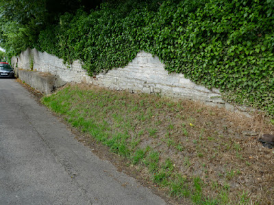
On the east side of the road, where the high boundary wall presumably marks the limit of the immediate grounds of Loversall Hall, there is a sloping bank of soil that passes into a very ‘amateur looking’ concrete structure that I presume has been designed to support the wall above.
Looking very closely at this, I can see that this coincides with an exposure of very thinly bedded limestone in this very shallow road cutting and, a little further up Bubup Hill, the wall lying directly upon it comprises stone blocks that are massive in the lowest courses and thinly bedded above.
When undertaking surveys of sites for the Doncaster Geodiversity Assessment, the very few quarries in the Brotherton Formation that I saw, as well as in the railway cutting at Warmsworth, displayed a small proportion of beds of thickness of 200 mm and most of the stone would have been unsuitable for use as a building stone.
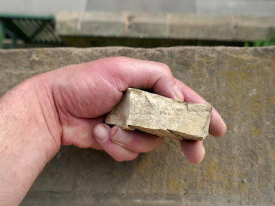
The sample of limestone that I obtained, without having my Estwing hammer with me, is buff/grey in colour, has a bed height of no more than 30 mm, is very finely crystalline and has tiny grains of black manganese oxide disseminated on the bedding planes.
As I had seen earlier in the day on Main Street in Wadworth, attempts have been made to consolidate the rock outcrop that forms the foundations for the eastern wall of the house on the opposite side of Bubup Hill, with roughly applied swathes of sand and cement.
Walking along Rake's Lane on my way to St. Katherine's church, the few houses and agricultural buildings that I saw wouldn't look out of place in any of the villages that are set on the Cadeby Formation. They are built out of cream/yellow dolomitic limestone that appears to be predominantly massive in nature, with subordinate thinly bedded limestone, but I didn't get close enough to examine them in detail.
The 1854 Ordnance Survey (OS) map shows one disused and two active quarries in the vicinity of the village, which would have presumably supplied some building stone from their thicker beds. The more massive stone, especially for the better quality houses are likely to have been sourced from the Cadeby Formation, which outcrops less than 2 km away.
The oldest parts of St. Katherine's church, which I will describe in my next post, are built of thin bedded rubble walling that is probably locally quarried, with quoins and dressings made of massive limestone that was undoubtedly quarried from the Cadeby Formation.
Returning to Bubup Hill, which takes a right angled turn at the junction with Rake's Lane, I stopped to photograph Loversall Farm, which is mentioned in the description of Loversall Conservation Area as being the major farm in the village and its importance reflected by having three storeys.
Continuing my walk, the unlisted buildings on Bubup Hill are all marked on the 1854 OS map and show the same pattern of building stone, with the converted agricultural building fronting Bubup Hill – now part of the Pear Tree Mews develoment – being built with limestone that is quite yellow.


No comments:
Post a Comment