 |
| A detail of the former Yorkshire Penny Bank |
After spending nearly two hours in Horbury, to look at the Church of St. Peter and St. Leonard and some of its historic architecture, I got on the No. 126 bus to Ossett and it immediately began to rain and, 10 minutes later when I alighted at Prospect Road, it was falling very heavily.
Just before this, from the top deck of the bus I had noted a few Victorian buildings on Station Road that have architectural features usually associated with listed buildings but, having prepared a British Listed Buildings Photo Challenge, I discovered that there are 12 listed buildings in the Ossett Ward and only 4 in the town centre.
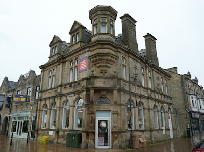
On the north side of Station Road, on the corner with Prospect Road, the former Yorkshire Penny Bank (1893) is built with muddy grey/brown rock-faced walling stone and massive sandstone for the door surround and dressings, which has a very similar colour and pattern of iron staining.
Looking closely at the intricately carved details to the dressings, at ground floor level and on the pediment to the splay, the sandstone is still in a very good condition after more than 125 years and, in Sheffield, I would normally associate this durability with the medium grained sandstones from the Millstone Grit Group.
Ossett is set on an unnamed sandstone in the Pennine Middle Coal Measures Formation, (PMCMF) but the Storrs Hill Quarry and Horbury Quarry in the Horbury Rock are not far away. The geological memoir considers it to be quite a soft sandstone and, as I had seen in the vernacular buildings of Horbury it is often not very durable and, for substantial architect designed buildings, Crosland Hill stone and other best quality West Yorkshire sandstones are used for dressings.
The Building Stones of England Database map explorer shows that Ossett is not far away from the Thornhill Rock, which is one of the better quality sandstones that was once widely quarried in the Wakefield district and was used to build Morley Town Hall.
Opposite the Yorkshire Penny Bank building on Station Road is the Liberal Club (1893), where the rock-faced walling and the ground floor ashlar have a similar appearance and the intricate carving is again in very good condition.
Before continuing along Station Road towards Market Place, I took a few photos of a terrace of shops and houses and a detached house on the south side of Prospect Road, where the walling is composed of muddy grey/brown rock-faced sandstone, with more massive iron stained dressings. These modest buildings first appear on the 1907 Ordnance Survey map and are presumably built out of local PMCMF sandstone.
With the rain still falling heavily, it was as much as I could do to take photographs with one hand while holding my umbrella with the other, so I did not look closely at the sandstone at any of the above buildings or the Mechanics Institute and Technical School (1889) by W. A. Kendall, which was later used as the library.
Recorded in Domesday Book as Osleset, Ossett was a predominantly agricultural community until the Industrial Revolution when coal mining became very important and, like nearby Dewsbury, it was at the heart of the shoddy and mungo industry - as part of the Heavy Woollen District.
At the time the 1893 edition of the Ordnance Survey was published, Ossett had become quite a substantial town and the buildings that I had seen to date reflected its prosperity and, as with very many other West Yorkshire towns, although built much later than originally planned, Ossett Town Hall (1907) reflects the civic pride that was a great feature of them.
Unfortunately, the building was scaffolded at the time of my visit and, except for the large round gables at each end, there was very little to see of the building and I made no attempt to zoom in with my camera to see the details. I didn’t stop to examine the stone, but it is probably one of the best quality West Yorkshire sandstones and the caryatids flanking the doorway are carved from massive blocks of uniformly buff coloured sandstone.
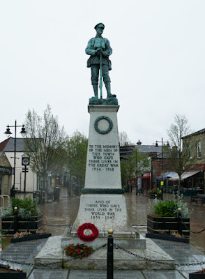
Ossett war memorial (1928), designed by the borough surveyor Mr H. Holmes and local architect Mr C. Kendall and sculpted by Robert Lindsay Clark, now forms a prominent feature in the large triangular market square, after being relocated twice in 1954 and 2001, but I didn’t get close enough to look at its details.
On the corner with Wesley Street is another former bank premises, originally built as the London City & Midland Bank (1891), using similar types of sandstone to those previously seen in the substantial buildings on Station Road.
Walking down Bank Street, I came across yet another former bank, the Wakefield and Barnsley Union Bank (1870). the Horbury and Ossett Family History Society refers to reports in the Wakefield Express, which describes it as being built in a Renaissance style design by William Watson of Wakefield, with the builders being Eastwood and Tolson and the stone used being Elland stone - presumably the massive variety of sandstone from the Elland Flags.
On the ground floor, the keystones are adorned with sculpted heads that are considered to include the classical deities: Minerva, Venus, Mars, Diana, Hebe and Mercury, but the head above the later portico is in a more modern style. These remind me of the keystones that adorn very many buildings of a similar age in nearby Dewsbury and I therefore wonder if there are links between the architects and sculptors.
 |
| Sculpted keystones on the Wakefield and Barnsley Union Bank building |


No comments:
Post a Comment