Monday 31 July 2023

Wath-upon-Dearne & West Melton III

 
Christ Church in West Melton

Returning to the Barnsley Road from Wet Moor Bridge, having had a brief exploration of Wath-upon-Dearne, I started my exploration of West Melton, a former coal mining village that grew rapidly from a small linear settlement that stretched along Melton High Street – as seen on the 1855 Ordnance Survey map.
 
The 1855 Ordnance Survey map of West Melton
 
Passing various stone terraced houses, which were built when the coal mining industry along the Dearne valley grew rapidly in the second half of the C19, the first listed building that I encountered was Nos. 131-133 – a coursed rubble built C18 farmhouse and cottage that has timber elements that are probably late mediaeval in date. 
 
Nos. 131-133 Melton High Street

The weathered and slightly blackened surface hides its true colour and textural characteristics, but the underlying bedrock is still the Oaks Rock and it is quite likely that the quarries I had identified at Wath-upon-Dearne would have supplied the stone.
 
The barn to the north of Nos. 143-145 Melton High Street

A little further down the road is the barn to the north of Nos. 143-145, which was built no later than the middle of the C18 and again has roof timbers that are dated to the C17 or earlier. The masonry is again weathered, but this time a distinct yellow/orange colouration is visible and consistent with the Oaks Rock.
 
Highfield Farm
 
Moving on to Highfield Farm, a large complex of farm buildings that was built in two phases, the first constituting 4 buildings from c.1750-1773-4 for the 2nd Marquess of Rockingham, with a later building for the Fitzwilliam family between c.1800-1855 - according to Historic England. 
 
Beech House

I could only get glimpses of the adjacent late C18 Beech House, through the trees from the public footpath and from the churchyard at Christ Church (1855), which was next on my list to photograph for the British Listed Buildings website.
 
Christ Church
 
As with most Victorian churches that I have visited, when quickly walking around its exterior, I didn’t notice anything of archaeological interest or take a close look at its blackened stonework but, for future purposes, I have noted that the architect responsible was Pritchett & Son – a practice that I am not familiar with. 
 
The York and Lancaster regimental crest

I had a wander around the churchyard, which contains a few Portland stone Commonwealth War Graves Commission headstones, but I did not find any new regimental crests. I just took a few record photos of their condition, including the headstone of Private S. Sanderson of the York and Lancaster Regiment, which is a replacement that has been inscribed with a CNC machine. 
 
Various buildings and walls on Melton High Street

After taking a few photos of the stonework to the old farm opposite the church and the terrace of cottages next to the churchyard, which exhibit characteristics of colour and texture that I had seen elsewhere in the Oaks Rock. 
 
A boundary wall on Hayes Walk
 
I stopped briefly to photograph the boundary walling that had been newly built as part of the new housing development on Hayes Walk, where the iron stained sandstone of unknown provenance has some very unusual dark brown/purple colouration, which I thought didn’t look very natural and wondered if it could possibly be spray paint. 
 
An exposure of Oaks Rock at No. 155 Melton High Street

Retracing my steps along the south side of Melton High Street, when looking for the public footpath back to Wath-upon-Dearne, I noticed an outcrop of the Oaks Rock in the drive to No. 155 and, seeing the owner in the garden, I went down to ask permission to take a few photographs. 
 
A sample of Oaks Rock from No. 155 Melton High Street

Although I had my Estwing hammer with me, I just collected a small loose sample, which is yellow/brown in colour, medium grained and contains some degraded iron bearing minerals and possibly feldspar. Returning to Melton High Street and finding the public footpath, I then set off towards my next destination, Newhill Grange. 
 
The path to Newhill Grange

Sunday 30 July 2023

Wath-upon-Dearne & West Melton II

 
Wath-upon-Dearne war memorial

After half an hour spent briefly exploring High Street and Sandygate, where I noted the light brown/yellow/orange colour variations in the Oaks Rock, I walked past the market cross and the former Cross House (1810) and onto Church Street. 
 
The former Cross House
 
The Spedding Whitworth fountain commemorates the maltster and brewer Spedding Whitworth, who formed Whitworth, Son and Nephew Ltd and became a prominent figure in Wath-upon-Dearne. The fountain, which is sadly neglected and needs cleaning, is built in dark grey granite that may be from Rubislaw Quarry, with pink Peterhead granite used for the shafts and bowls. 
 
The Spelling Whitworth fountain
 
Further up Church Street, I stopped at the Montgomery Hall Theatre, where there is a modern relief sculpture that depicts the Scottish poet and hymn writer James Montgomery. I have seen this many times, but have not managed to find out any information about the artwork or the sculptor, except that the latter seems to have added the initials JB to the work. 
 
A relief sculpture at the Mongomery Hall Theatre
 
After photographing the rendered Town Hall (1770), I just took a couple of photos of details at All Saints church, but I had already had a good look at its stonework during previous visits and didn’t spend any more time here. 
 
Details of All Saints church

On the opposite side of the church, a converted farm building provides another example of yellow/orange sandstone, which was very notable on Sandygate, as does the early C19 lock-up on Thornhill Place, which has now been converted into a residence. 
 
The lock-up on Thornhill Place
 
Retracing my steps to the churchyard, I then my way down the public footpath to West Street to firstly look at the late C18 or early C19 Brook Farmhouse, where local sandstone from the Oaks Rock has been used, although it has been partially rendered. Built with three storeys and three bays, it has a simple well proportioned main elevation, which has a triangular pediment to the doorway and a segmental pediment with a festooned frieze to the central first floor window. 
 
Views of Brook Farmhouse

To the left side and rear of Brook Farmhouse, there is a range of early C19 agricultural buildings, now converted into dwellings, which is built in iron stained yellow sandstone. It is the dovecote and cowhouse that are Grade II listed here and, after finding various viewpoints from which to photograph them, I carried on with my walk. 
 
Farm buildings with a dovecote and cowhouse
 
Despite having a print out of a 1:25,000 Ordnance Survey map with me, which has the cross country public footpath clearly marked, I couldn’t find this on the ground and I had to follow the Barnsley Road to get to Wet Moor Bridge (c.1800), which crosses the now infilled Dearne and Dove Canal.
 
The south elevation of Wet Moor Bridge


Wednesday 26 July 2023

Wath-upon-Dearne & West Melton I

 
A sculpture on the doorway of Strathmore House on Sandygate

Following on from my recce of Otley Chevin, for the next field trip of the Sheffield U3A Geology Group, my next day out involved a circular walk from Wath-upon-Dearne to West Melton, in Rotherham, to provide photographs for the British Listed Buildings website. 
 
Listed buildings in Wath-upon-Dearne and West Melton

As usual, I made this a reason to have a good look at the various building stones in the vernacular architecture and boundary walls, which reflect the underlying geology. On this occasion, it is the Oaks Rock in the Pennine Middle Coal Measures Formation that underlies the area – a sandstone that I had no doubt seen in the town during my last visit to All Saints church, but one that I had not closely investigated. 
 
On the 1855 Ordnance Survey map, a few quarries are marked around Quarry Hill Lane, which was probably the main centre of the local quarrying industry, but there are others on the Oaks Rock and it is very probable that the majority of the historic buildings in Wath-upon-Dearne are built with sandstone from this formation. 
 
Quarries marked on the 1855 Ordnance Survey map
 
The British Geological Survey memoir, the Geology of the Country Around Barnsley (1947) describes the Oaks Rock as having a characteristic brown, yellow or light-yellow colour and being fine grained, often flaggy and current bedded. Alighting from the No. 22x bus on Manvers Way, I made my way up Staion Road to the mid C18 Nos. 54-56 High Street, where this colour variation with occasional reddening is seen, along with a considerable quantity of clay ironstone pellets. 
 
Nos. 54-56 High Street

Walking west along High Street to the corner of New Road, the unlisted No. 48, which also appears on the 1855 Ordnance Survey map, is built with a sandstone that is quite uniformly yellow/pale brown in colour, with differential weathering picking out both planar and cross-bedding. 
 
No. 48 High Street
 
Continuing along High Street, I passed various sandstone buildings, including a pair of late Victorian semi-detached houses at Nos.44-46, a cart shed (1745) to the rear of No. 22 and a former mid-late C18 house on the corner of Sandygate. The latter does not have tooled masonry, which collects dirt and makes it harder to see the colour variation, and it looks very similar to that seen at Nos. 54-56 – including the abundant clay ironstone pellets. 
 
Various buildings on High Street
 
Making my way up Sandygate to No. 34, the former early C19 blacksmith’s workshop, the sandstone used for this is quite yellow with iron banding and not particularly durable, with softer beds again being differentially weathered to reveal the cross-bedding. 
 
No. 34 Sandygate
 
Further up Sandygate, the batted finish of the masonry to Nos. 44-46 (1771) again slightly obscures the physical characteristics of the sandstone and, although there is a moderate amount of iron staining, much of the sandstone is light brown in colour. 
 
Nos. 44-46 Sandygate

Of those marked on the 1855 Ordnance Survey map, very many of the buildings on Sandygate still exist and nearly all of the older buildings are built in sandstone that is quite yellow/orange and not light brown, as I had seen in the buildings of High Street. The same map marks a quarry just to the south side of Sandygate and it is quite likely that the sandstone for its buildings came from here. 
 
Various buildings on Sandygate
 
Walking up to the corner with New Road, I was interested to see Strathmore House (1866), which has some interesting architectural details - including floriated capitals to the shafts in the bay window and to the front door and a figurative frieze sculpture to the trefoiled tympanum above.
 
Strathmore House
  

A Recce at Otley Chevin - Part 2

 
Surprise View at the crest of The Chevin

Continuing our recce of the western end of Otley Chevin Forest Park, where the signposting is not so clear, Paul and I went in search for marker No. 4 on the Geology Trail that depicts the Carboniferous horsetail Calamites, to which the much smaller modern species are closely related. 
 
Marker No. 4
 
Crags of the Doubler Stones Sandstone and very large slipped blocks are exposed here. They display prominent slumped bedding and soft sediment deformation structures, which are caused by dewatering and highlighted by differential weathering of the graded beds. 
 
Doubler Stones Sandstone crags with soft sediment deformation

One particularly large block has been rotated at 90 degrees, which can be determined by the vertical orientation of the well defined cross-bedding. On the exposed bottom surface are several fragments of fossil tree branches, which would have been washed down the river after a flash flood and deposited as a log jam. 
 
Fossil tree branches
 
We had a good wander around the crags looking at the various sedimentary structures, without finding marker stone No. 5; however, there was no problem finding several large slipped blocks, where the cross-bedding is highlighted by the thick covering of moss and there are further examples of deformation structures. 
 
Slipped blocks

Following the path past a pond, the next stop was another outcrop of the Doubler Stones Sandstone at the south side of the disused Yorkgate Quarry, where marker stone No. 6 shows dimpling of the rock surface cause by fossil tree roots. 
 
Marker No. 6
 
The sandstone here dips to the south at an angle of 24 degrees and, taking care not to slip on the slope, we made our way to the top of the outcrop and searched for the fossil roots on the bedding plane, although these were not easy to see even after we had got our eye in. 
 
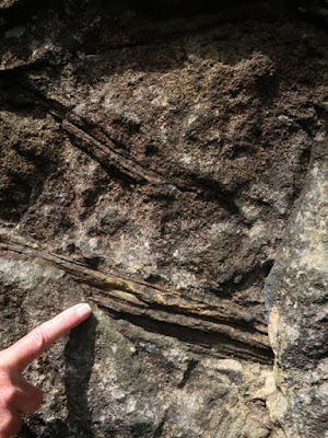
A bedding plane at Yorkgate Quarry
 
Collecting a couple of pieces of sandstone from a part of the outcrop that had been indiscriminately hammered, the carbonised tree roots are quite clearly seen with the naked eye. An examination of this yellow sandstone with a hand lens further reveals it is medium/coarse grained with a scattering of feldspar that is sometimes pink in colour. 
 
A specimen of Doubler Stones Sandstone with tree roots
 
In one small exposure, above the bed of sandstone with tree roots, is a grey fireclay – the soil in which grew the trees and vegetation that turned into coal – immediately above which is a thin seam of the Morton Banks Coal. 
 
An exposure of Morton Banks Coal

After taking a late lunch, we continued to marker No. 7 on the other side of the quarry, where the Geology Trail route leaflet refers to the Variscan Orogeny, seen at the beginning of the day at the East Chevin Quarry car park, but the sculpture depicts a stonemason’s hammer and chisel - as recorded in the general account of the geology. 
 
Marker No. 7

The large quarry face here is not accessible from the footpath, but the steep 24 degree dip of the sandstone can be clearly seen, as can the change from very massive sandstone in the lower part of the quarry to the more flaggy varieties at upper levels, which are emphasised by surface weathering processes that lead to the formation of the soil profile. 
 
A quarry face at Foxgate Quarry
 
Making our way along the path along the ridge to Surprise View, in the distance to the north can be seen a prominent landform known as Almscliff Crag. This is formed from Warley Wise Grit and, together with the Pendle Grit Member, forms the lowest sandstone in the Millstone Grit Group. 
 
Almscliff Crag
 
The craggy outcrop of the Doubler Stone Sandstone forms the crest of The Chevin and, as seen in the Chatsworth Grit along the gritstone edges in Derbyshire, it comprises a very coarse grained sandstone with an abundance of quartz pebbles. 
 
Coarse pebbly Doubler Stones Sandstone at Surprise View

Marker No. 8 is a carving shows the swirling, fast moving currents that would have transported the very large pebbles of quartz along the ancient river bed. As with all the other markers seen on the walk, it is made of Midgely Grit from the Blackhill Quarry in Bramhope. 
 
Marker No. 8
 
At Surprise View, there is an excellent interpretation panel that is dedicated to the geology and geomorphology of the region and to the Quaternary history of Wharfedale below, along which flowed a glacier that once covered The Chevin.
 
The interpretation panel at Surprise View
 
Having completed the Geology Trail, before heading back down to the car park, we finished the day by taking a quick look at the dry stone wall that was being repaired. I don’t if any new stone was being used, but it provides a good example of the range of colours and textures seen in the local stone, which includes some very bright red colouration. 
 
A dry stone wall at Surprise View
 

Sunday 23 July 2023

A Recce at Otley Chevin - Part 1

 
An exposure of Addingham Edge Grit

After visiting Barnsley in the last week of May, to see the Burton Bank quarry and investigate the building stones in the Barnsley Old Town Conservation Area, I started June 2022 by going on another recce with Paul, the group leader of the Sheffield U3A Geology Group – this time to visit Otley Chevin Forest Park, on the south side of Wharfedale in West Yorkshire. 
 
The Geology Trail

Using a leaflet produced jointly by the Leeds Geological Association, the West Yorkshire Geology Trust and the Friends of Chevin Forest, our plan was to find the eight locations that are marked with stone sculptures by the local artist Shane Green. 
 
The Geology Trail

Starting off from Sheffield on the M1, we eventually arrived at the East Chevin Quarry car park, having relied on Paul’s Sat Nav to take us on a very convoluted route around the east side of Leeds, when I would have just navigated in an old fashioned way, using his road atlas and following signs to Leeds Bradford Airport. 
 
A section through The Chevin reproduced from the Geology Trail

At the beginning of the path, the first sculpture that we encountered records the Variscan Orogeny, which formed the Pennines in the late Carboniferous and early Permian periods, ending approximately 290 million years ago. 
 
The Variscan Orogeny sculpture
 
The first marker, which shows waves and the moon above it, directed us to an outcrop of thin beds of fine sandstone of uniform thickness, which have been interpreted by Neil Aitkenhead of the British Geological Survey as being tidal laminites, with each bed of sandstone being deposited by the ebb/flow of the sea and differences in thickness attributed to the amount of sediment distributed by spring and neap tides.
 
Geology Trail marker No. 1
 
I counted over 40 individual beds which, according to the leaflet, would imply that over a metre of sandstone exposed here would have been deposited in just over 3 weeks, which would presumably require extremely rapid subsidence of the sedimentary basin. 
 
An exposure of tidal laminites
 
Being unable to access the original paper in the Proceedings of the Yorkshire Geological Society, I would be interested to see how the preservation of such a thickness of soft sediment in a tidal environment and its relationship with the massive cross-bedded Addingham Edge Grit, which occurs at the same level a few metres away, is explained. 
 
A detail of the tidal laminites
 
Continuing up the path, the outcrop of massive Addingham Edge Grit has been quarried extensively, with many exposures visible from the path. It is very conspicuous for having its joint planes very heavily iron stained, which gives the rock a deep rusty red colour in many places.
 
Quarry exposures of the Addingham Edge Grit

I obtained a small sample of sandstone with my Estwing hammer, which is coarse grained, feldspathic and orange/brown in colour, with darker bands that have a very high iron content. On the weathered face, however, it has a developed a patina that lacks the bright iron staining and is quite dull in comparison. 
 
A sample of Addingham Edge Grit
 
After passing the quarry faces, we passed a patch of ground where there was a notable change in the vegetation to bog loving plants, which marks a spring at the junction of the mudstone and the overlying Addingham Edge Grit.
 
Bog loving plants growing at the edge of a spring

Fololowing a path that took us above this formation, we then encountered an unusual feature called the Vacca Wall, which is formed of large upright stones placed at the edge of a steep slope that falls down to the valley below. They were built as field enclosures associated with the vaccary system of cattle farming and several of these can be found in the Pennine area.
 
The Vaccary Wall
 
Somewhere along the walk, we had missed the marker at the quarried crags and the next one that we encountered had a carving of a goniatite, which can sometimes be found in the marine bands in the area. This marks the position of the Great Dib landslip, where large blocks of the Long Ridge Sandstone have slipped down the hillside, during periods when the underlying mudstone was lubricated during periglacial conditions. 
 
Geological Trail marker No. 3

All along the north facing slope of The Chevin, the strata have been prone to landslides and, diverting from the path, we could see an irregular landscape on the slopes below that is dominated by large slipped blocks. 
 
A view of the landscape on the Great Dib Landslide

Making our way along the path, which in places was very muddy after the recent heavy rain, beds of mudstone along its edges have weathered to yellow clay, a feature that I had seen very often when exploring the stream banks in the Coal Measures strata around Sheffield.
 
Beds of mudstone weathered to yellow clay