Wednesday 24 February 2021

Brancliffe Grange to Wood Mill Quarry

 
Red stained limestone at Wood Mill Quarry
 
Continuing my walk from Shireoaks to South Anston, in the first week of August 2020, having encountered some interesting geology in a drainage ditch just south of Brancliffe Grange, which included glaciofluvial pebbles, I continued along the path up towards Moses’ Seat.
 
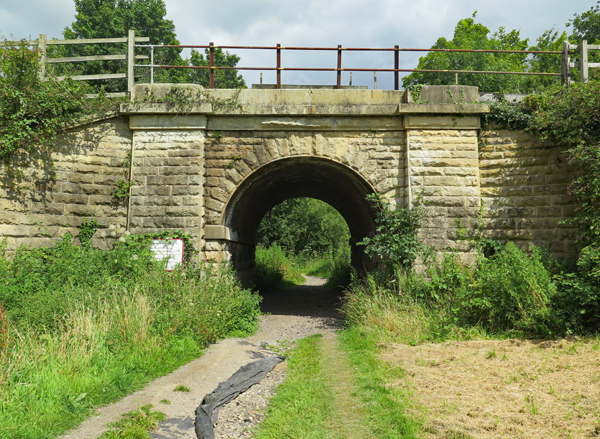
The track to Moses' Seat

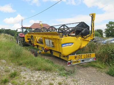
My walk coincided with the beginning of the wheat harvest and, before I got very far, I had to make way for a tractor that was pulling the detached header of a combine harvester behind it. Having never been so close to one before, I just had to take a few photos before it got out of range.
 
A view towards Moses' Seat

I then looked behind me and noticed that the combine harvester itself was just setting off from what looked like some distance away. Before not too long, however, I became very aware that it was approaching fast behind me and, although I only had to cover a total distance of less than 200 metres, it made me quicken my step – with very many anxious looks behind me.
 
A view south-east towards Shireoaks

Unfortunately, this did not give me any time to look in the edges of the field, to find other signs of glaciofluvial pebbles or other rocks that are obviously not derived from the underlying dolomitic limestone. I was also unable to have a good look at the landscape around me – particularly the sandstone ridge of the Triassic Chester Formation, which lies in the far distance beyond the landscaped Shireoaks colliery tip.

A view south from Moses' seat to Brancliffe Grange

Arriving at the top of the hill, I encountered several fellow walkers who had stopped to wait for the combine harvester to arrive and, when I talked to a few of them, it seemed that my efforts to keep ahead of it had been a great source of amusement.
 
Limestone adjoining the path to the River Ryton

Walking down a well worn path into the valley that is occupied by the River Ryton, exposures of dolomitic limestone from the Cadeby Formation made me think that I might see further exposures of this rock along the steep slopes here; however, I decided not to deviate from my planned route and continued down towards the river.
 
Blocks of dolomitic limestone

Before reaching the valley bottom, I was surprised to encounter a small man made channel, which I now know to be the feeder of the Chesterfield Canal. This flows eastward from the southern end of Lindrick Dale before snaking back south-westward to Brancliffe Grange and then again turning east towards Turnerwood, where it joins the canal.
 
The feeder for the Chesterfield Canal

Crossing the bridge, I followed the path westwards through the southern part of Lindrick Golf Club, from which I could see the heavily wooded valley that is occupied by the nascent River Ryton – just east of the confluence of the Pudding Dike and Anston Brook.
 
A view towards the River Ryton from Lindrick Golf Club

Entering the southern end of Lindrick Dale, before exploring this gorge, I went to have a look at the old Wood Mill limestone quarry, which I had last visited back in 1997, when surveying potential RIGS (Regionally Important Geological Sites) in Rotherham.
 
A general view in Wood Mill Quarry

Very many of the old faces are now obscured by trees and dense shrubs, but there are still some good exposures of massive limestone with thick beds. The Sheffield memoir describes some of the limestone in Lindrick Dale as a massive, compact and granular limestone of a type that is intermediate to the lower and upper subdivisions of the Cadeby Formation but I didn’t examine the rock faces in any detail.
 
A section of massive bedded limestone

I was more interested in the red iron oxide staining on some of the quarry faces and, although dense hawthorn prevented easy access, I managed to get some photos. I couldn't see any red beds here, but I had encountered lenses of red marl in limestone of the upper subdivision – the Sprotbrough Member - at Levitt Hagg in the Don Gorge, while undertaking surveys for the Doncaster Geodiversity Assessment, and also similar red staining at Creswell Crags.
 
Red stained limestone

A group from the Sheffield Area Geology Trust visited this quarry in 2019, when they looked for sedimentary textures that have survived the alteration from limestone to dolomite. They also examined what was considered to be an exposed fault plane, with slickensides and partially covered with flowstone, but I didn’t notice any of these features.

Red stained limestone

Monday 22 February 2021

Glaciofluvial Pebbles and Cobbles


Brancliffe Grange pebbles and 'Bunter' pebbles
 
In the drainage ditch at Brancliffe Grange, all of the pebbles and cobbles that I saw were of the same yellow/brown colour and these were sporadically scattered throughout the yellow/red soil horizon and the brown loam above the unweathered red marl of the Edlington Formation. The samples that I collected for examination from a heap at the edge of the field, therefore, are representaive of the exposure as a whole.
 
The drainage ditch at Brancliffe Grange

I don’t own a microscope or sawing and polishing machinery, and I am not affiliated with any academic institutions or testing laboratories, so I have to rely on my eyes, a hand lens, a steel knife and a bottle of hydrochloric as my tools - and British Geological Survey maps and memoirs as my principal sources of reference.
 
The geological tools at my disposal

Although none of the geological maps that I have access to show any Quaternary deposits in the immediate area around Brancliffe Grange, the Sheffield memoir mentions that a scattering of glaciofluvial pebbles and cobbles throughout the district show where more substantial deposits must have been.
 
To the east of Doncaster, there are vast spreads of both Quaternary glaciofluvial and river terrace deposits, which contain pebbles that mirror the bedrock over which the glaciers and rivers flowed. Although I didn’t collect specimens, I visited many quarries where these are exposed, when undertaking survey work for the Doncaster Geodiversity Assessment.
 
Exposures of Quaternary sand and gravel in Doncaster

In the river terrace deposits, those to the north are predominantly composed of pebbles of Carboniferous sandstones and Permian limestones, over which the precursor to the River Don flowed. In the south, the pebbles are mainly of the 'Bunter type' deposited by the River Idle, which flowed from the south across the Triassic sandstones of the East Midlands, where these pebbles are very abundant.
 
Glaciofluvial pebbles at Cedar Road Quarry

The dispersed and relatively infrequent Brancliffe Grange pebbles, however, are much more like those that I saw in the glaciofluvial deposits above the Chester Formation at Cedar Road Quarry in Doncaster and I would therefore assign a similar origin to them.
 
A comparison with 'Bunter' pebbles

Examining the Brancliffe Grange pebbles closely, they consist of hard sandstone with a siliceous cement that has been polished to the extent that the individual grains can barely be determined and they are quite quartzitic in appearance.
 
A comparison with 'Bunter' pebbles
 
Compared to well rounded ‘Bunter’ pebbles of white vein quartz and quartzite that I took directly from the Chester Formation at Alton Towers, they are also distinctly angular. Although not as well developed as the dreikanter that I collected at Common Lane Quarry in Doncaster, their faceted form identifies them as ventifacts – pebbles that have been polished by wind driven sand or ice crystals in a periglacial environment.
 
A dreikanter from Common Lane Quarry

The coarser grained sandstone cobble that I also collected is much larger than those typically seen in the river terrace deposits and, although not faceted, it has also been polished. In parts of Doncaster that are near to glaciofluvial deposits such as these, cobbles form the oldest parts of the churches at Kirk Sandall, Fishlake, Hatfield and Thorne.
 
A sandstone cobble
 

Friday 19 February 2021

Geology at Brancliffe Grange


An exposure of the Edlington Formation
 
During my exploration of Shireoaks and the Chesterfield Canal in week 19 of the COVID-19 Pandemic, just before Cinderhill Lock I noticed a very well made sign produced by the Peak & Northern Footpath Society, which drew my attention to the bridleway to Woodsetts via Lindrick.

A sign by the Peak & Northern Footpaths Society

Now that the pubs were back open, as I had discovered during my previous walk, this gave me a little bit more flexibility with the rural bus timetables and for my next trip. A week later, in the first week of August 2020, I planned a walk from Shireoaks to South Anston via Lindrick Dale and Anston Stones Wood, where there is some very interesting geology.

A bridge on the Sheffield to Lincoln railway line

Joining the canal again at Shireoaks station, after a few hundred metres I turned onto the bridleway and, continuing around the edge of a flat field, I then came to the rock faced Grade II Listed railway bridge, built c.1849 by the eminent railway engineer - Sir John Fowler.

A panoramic view of the landscape around Brancliffe Grange

Passing under the bridge, I followed the path parallel to the railway line and I wouldn’t have stopped, if it wasn’t for the piles of bright red soil that were scattered along the edge of the field. Investigating further, I was fascinated to see that a drainage ditch had been freshly cut, which exposed the marl of the Permian Edlington Formation and the soil horizon above.

A view along the drainage ditch

I had only encountered this formation before at New Edlington brick pit in Doncaster, where a bed of gypsum was exposed at the edge of a pond that was now used for fishing; however, this calcareous mudstone is barely lithified and, in the British climate, it soon turns back to its original form and is quickly overgrown by vegetation.

Gypsum at New Edlington

Standing close to the edge of the ditch and looking as closely as I could at the other side, without falling in, I was particularly interested to see that the red marl passed upwards into a soil horizon that was full of pebbles and cobbles.

A section through the drainage ditch

 
The Edlington Formation was formed approximately 252 to 272 million years ago in an environment dominated by lakes and lagoons and, although the formation contains some coarser grained sandstone and chemically precipitated evaporites, it is not pebbly by nature.

A detail of the section

After taking many photographs of the sections exposed here, I collected some fragments of marl and a few pebbles from one of the heaps at the edge of the field, which varied in size from a walnut to a large baking potato.

A cobble of coarse grained sandstone

Noting particularly that the smaller pebbles were smoothly polished, I placed the marl in a sample bag and carefully packed all of the specimens into my rucksack, before continuing my walk to Brancliffe Grange and the mound like landform known as Moses’ Seat beyond.

Rock samples in dull and bright light

When undertaking survey work for the Doncaster Geodiversity Assessment, I encountered various exposures of Quaternary glaciofluvial and river terrace deposits, which contained similar pebbles; however, when finally returning home and referring to the British Geological Survey online map viewer, I was interested to see that were none marked here.

The geology between Shireoaks and South Anston

Sunday 14 February 2021

From Kiveton Park to South Anston


An escarpment of the Cadeby Formation at South Anston

When planning my exploration of the Chesterfield Canal, I had intended to walk from Shireoaks to Kiveton Park station, where I would then catch the X5 bus to Sheffield; however, when coming to the very end of my walk, the bus came whizzing past before I could get to the bus stop.
 
The Anston parish boundary stone

It was not yet 3 o’clock and having only walked 6 km, rather than hang around in this lifeless place, I continued my walk to South Anston, where I knew that I could catch this bus and have a beer at the Leeds Arms – a watering hole that I had used before when exploring the area.
 
Dog Kennel Hill
 
I had never walked along this road before and, with this being the route that was taken by teams of eight horses that dragged stone from the Anston quarry to Dog Kennels, loaded on low, wheeled wooden platforms called ‘drugs’, I was interested to see what this would entail.
 
The geology around Kiveton Park and South Anston

From the top deck of the bus, it is possible to get glimpses of the large disused quarry in the Permian Cadeby Formation to the west of Dog Kennel Hill but, not being able to do so when walking, I was content to take in the views of the surrounding landscape and get a good appreciation of the landforms.
 
A view west to Kiveton Lane across till and head
 
Once beyond the built up area and into open countryside, the bedrock geology changes from the Cadeby Formation to the younger Upper Carboniferous Mexborough Rock, which are separated by an unconformity, but the whole area is overlain by a blanket of Quaternary till and head.
 
An escarpment of the Cadeby Formation
 
To the east, the escarpment formed by the Cadeby Formation can be easily distinguished and, in the distance to the south-east, the wooded landscape marks the position of the valley in which the Chesterfield Canal and the Sheffield to Lincoln railway are situated.
 
A view to the south-east across the Cadeby Formation
 
To the west-north-west, Todwick can be seen on the skyline, with one of the Penny Hill wind turbines at Ulley far in the distance. Even though the crops were at an advanced stage of growth in the last week of July, the red soil that is characteristic of the 'Rotherham Red' variety of Mexborough Rock could still be seen in the agricultural land on the outskirts of this village.
 
Reddened soil on the outskirts of Todwick

It didn’t take long before I arrived at the edge of South Anston, where I descended down a moderately steep hill that would no doubt have placed some strain on the horses that were pulling loads of stone up it.
 
Arriving in South Anston
 
On Crowgate, there is a mixture of brick built inter-war detached and semi-detached houses and a few Victorian villas that are mainly built in local dolomitic limestone, but they don't have any great architectural merit and so I didn’t stop to photograph them.
 
Rotherham Red sandstone and limestone in a boundary wall
 
Although limestone and red pantiles are the dominant vernacular building materials, Rotherham Red sandstone of unknown provenance is frequently mixed with the limestone in boundary walls. These show the relative durability of the two different stones, particularly when subjected to rising groundwater and road salt, and the colour variation of the sandstone is quite noticeable.
 
The Leeds Arms
 
Finally arriving at the Leeds Arms public house, having given my name and phone number in accordance with the COVID-19 Pandemic regulations at the time, I sat outside by myself and enjoyed a leisurely pint of Abbot Ale in the afternoon sunshine.
 
A pint of Abbot Ale
 
Very conveniently, the bus stop here is right outside the pub and, although I didn’t wander far up Sheffield Road, there is a good view of St. James’ church in the distance, which I had explored in detail a few years earlier.
 
A view of St. James' church

The Chesterfield Canal - Part 3


Albert's Dock

Walking along the Chesterfield Canal from Shireoaks towards Kiveton Park station, the highlights so far had firstly been the wonderful feat of civil engineering, in the form of the 23 locks and, secondly, the evidence of various sites where the underlying dolomitic limestone from the Cadeby Formation and marl from the Edlington Formation had been exploited for building materials.
 
An exposure of the Cadeby Formation

So far, not having deviated from the towpath, I hadn’t seen much direct evidence of the hard rock geology here, although the land beyond the canal bank just to the west of Pudding Dike Bridge did look like it had been disturbed.
 
A detail of  a limestone outcrop

A couple of hundred metres beyond Thorpe Bridge, however, there is a vertical rock face immediately adjacent to the south bank of the canal, where massive, vuggy limestone from the Cadeby Formation is exposed.
 
An exposure of limestone in an old quarry

Being so close to the water’s edge, I assume that this must be a cutting to accommodate the line of the canal, which here no longer follows the line of the Spa Fault. Together with the railway line here, it runs through a valley cut by a tributary of the River Ryton, which runs from Pebley reservoir south through Harthill down to Kiveton Park, before turning sharply to the east.
 
An overgrown quarry
 
Just a little further on, another old quarry with lime kilns is marked on the 1924 Ordnance Survey map, and this coincides with more irregular rocky exposures and a tract of obviously disturbed ground that extends for a short distance to the west.
 
The remains of a wall from the old malt house

Approaching Dog Kennels Bridge, at the end of a very interesting walk, there is the remains of a limestone wall, which has been dismantled to the levels of the window sills, and its position coincides with a large building that first appears on the 1894 map and is marked on the 1950 map as a large malt house.
 
An information board

Beyond this, a comprehensive tourist information board at Albert's Dock informed me that limestone from the Duke of Leeds’ quarry in North Anston was loaded onto 'cuckoo' boats here, to be shipped to London for the building of the Houses of Parliament.
 
A terrace of houses at Albert's Dock
 
On the south bank, there is a terrace of six houses at right angles to the canal, with various outbuildings, built in the local limestone, but I haven’t seen any record of these being associated with this aspect of the canal’s history.
 
A wall built in limestone and siltstone

The north bank is flanked by various remnants of structures
that once stood here, built in brick and stone – including grey siltstone from the Pennine Middle Coal Measures Formation - and which I assume were associated with the stone yard that was once found here; however, the historian for the Chesterfield Canal, Christine Richardson, would no doubt be able to throw more light on these.
 
A section of walling on the north bank
 
The final stretch of the towpath is flanked by a large retaining wall, built with pitch-faced stone. The lower part dates from the canal’s construction in 1777, with the upper part added around 1841, when it was raised to about 5 metres, to support the adjoining railway embankment.
 
A view along the retaining wall
 
During a recent phase of repairs to the wall, part of the wall was found to be the blocked-up entrance to a tunnel that connected to the nearby Turner’s Quarry - a supplier of Anston stone - where rough blocks of stone were precisely cut into smaller blocks before being loaded - which is also recorded by the Kiveton Park and Wales History Society.
 
Dog Kennels Bridge