 |
| An exposure of the Edlington Formation |
During my
exploration of Shireoaks and the Chesterfield Canal in week 19 of
the COVID-19 Pandemic, just before
Cinderhill Lock I noticed a very well made sign produced by the Peak & Northern Footpath Society, which drew my attention to the
bridleway to Woodsetts via Lindrick.
 |
| A sign by the Peak & Northern Footpaths Society |
Now that the pubs were back open, as I had discovered during my previous walk, this gave me a little bit more flexibility with the rural bus timetables and for my next trip. A week later, in the first week of August 2020, I planned a walk from Shireoaks to South Anston via Lindrick Dale and Anston Stones Wood, where there is some very interesting geology.
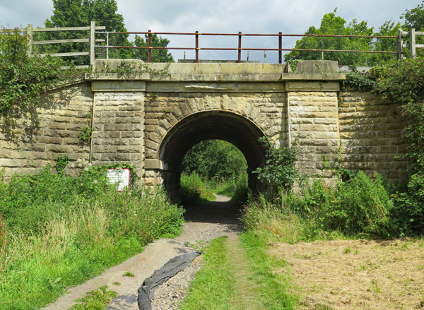 |
| A bridge on the Sheffield to Lincoln railway line |
Joining the canal again at Shireoaks station, after a few hundred metres I turned onto the bridleway and, continuing around the edge of a flat field, I then came to the rock faced Grade II Listed railway bridge, built c.1849 by the eminent railway engineer - Sir John Fowler.
 |
| A panoramic view of the landscape around Brancliffe Grange |
Passing under the bridge, I followed the path parallel to the railway line and I wouldn’t have stopped, if it wasn’t for the piles of bright red soil that were scattered along the edge of the field. Investigating further, I was fascinated to see that a drainage ditch had been freshly cut, which exposed the marl of the Permian Edlington Formation and the soil horizon above.
 |
| A view along the drainage ditch |
I had only encountered this formation before at New Edlington brick pit in Doncaster, where a bed of gypsum was exposed at the edge of a pond that was now used for fishing; however, this calcareous mudstone is barely lithified and, in the British climate, it soon turns back to its original form and is quickly overgrown by vegetation.
 |
| Gypsum at New Edlington |
Standing close to the edge of the ditch and looking as closely as I could at the other side, without falling in, I was particularly interested to see that the red marl passed upwards into a soil horizon that was full of pebbles and cobbles.
 |
| A section through the drainage ditch |
The Edlington Formation was formed approximately 252 to 272 million years ago in an environment dominated by lakes and lagoons and, although the formation contains some coarser grained sandstone and chemically precipitated evaporites, it is not pebbly by nature.
After taking many photographs of the sections exposed here, I collected some fragments of marl and a few pebbles from one of the heaps at the edge of the field, which varied in size from a walnut to a large baking potato.
Noting particularly that the smaller pebbles were smoothly polished, I placed the marl in a sample bag and carefully packed all of the specimens into my rucksack, before continuing my walk to Brancliffe Grange and the mound like landform known as Moses’ Seat beyond.
When undertaking survey work for the Doncaster Geodiversity Assessment, I encountered various exposures of Quaternary glaciofluvial and river terrace deposits, which contained similar pebbles; however, when finally returning home and referring to the British Geological Survey online map viewer, I was interested to see that were none marked here.
 |
| A detail of the section |
After taking many photographs of the sections exposed here, I collected some fragments of marl and a few pebbles from one of the heaps at the edge of the field, which varied in size from a walnut to a large baking potato.
 |
| A cobble of coarse grained sandstone |
Noting particularly that the smaller pebbles were smoothly polished, I placed the marl in a sample bag and carefully packed all of the specimens into my rucksack, before continuing my walk to Brancliffe Grange and the mound like landform known as Moses’ Seat beyond.
 |
| Rock samples in dull and bright light |
When undertaking survey work for the Doncaster Geodiversity Assessment, I encountered various exposures of Quaternary glaciofluvial and river terrace deposits, which contained similar pebbles; however, when finally returning home and referring to the British Geological Survey online map viewer, I was interested to see that were none marked here.
 |
| The geology between Shireoaks and South Anston |
No comments:
Post a Comment