Sunday 31 October 2021

An Exploration of Letwell - Part 2

 
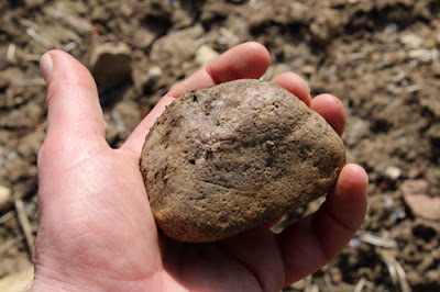
A pebble of coarse grained Carboniferous sandstone

Having spent an hour exploring St. Peter’s church and the historic buildings on Barker Hades Road in Letwell,- one of the most picturesque villages that I had seen in a long time, I was very curious about the red, limonite stained, sandy dolomitic limestone that I had been looking at.
 
A sample of sandy dolomitic limestone from a boundary wall
 
Prising out a small piece of stone from the boundary wall opposite the Old Rectory with my Rodgers stainless steel knife, it felt sandy when I rubbed it with my thumb. When looking at it later with my hand lens, in addition to fine grains of angular quartz, I could see many small black flecks that I couldn't identify.
 
The village pond set on red marl of the Edlington Formation

Continuing along Barker Hades Road to the village pond, where the surrounding red soil reminded me that the underlying bedrock here is the marl of the Edlington Formation, I then took a diversion from my planned route to take a photo of the dovecote, which I wanted to add to the British Listed Buildings website.
 
A distant view of the dovecote

On the path to the dovecote, although not marked on the geological map, I noticed that the surrounding fields were liberally scattered with a wide variety of well rounded pebbles in various sizes, as well as others that were more angular in nature.
 
The geology around Letwell

Many of these looked very similar to those that I had previously encountered around the Chesterfield Canal and Thorpe Salvin and when recently investigating the Quaternary geology around Kiveton Park, including coarse grained Carboniferous sandstone and vein quartz; however, others were not so easy to identify and they need an examination with a petrological microscope.
 
Samples collected from the field (21 mm diameter coin)

Looking down into the stream running alongside the path, although I could see no exposures of the red marl of the underlying Edlington Formation, the stream banks had occasional exposures of red clay full of pebbles and the streambed was covered in red sediment.
 
Exposures of red clay with pebbles in the stream bank

Saturday 30 October 2021

An Exploration of Letwell - Part 1

 
A high quality information board in Letwell

Walking back from St. Peter’s church to the centre of Letwell, Church Lane and then Barker Hades Road are lined with post-war houses, with only a large detached house, dated 2015, being built in Permian dolomitic limestone – although the stone was not locally quarried.
 
A  modern house dating to 2015 on Church Lane

On the corner of Barker Hades Road/Ramper Road, the first vernacular building that I saw in the village is a pair of cottages, now converted to a single house, which wouldn’t look out of place in most of the villages that I have seen on the Magnesian Limestone.
 
The house on the corner of Barker Hades Road/Ramper Road
 
Not being listed, I was more interested in the war memorial on the opposite side of the road, which has a simple shaft with a Celtic cross and is made from ‘Sicilian’ marble – a former name for veined white marble that comes from Carrara in the Apuan Alps.
 
Letwell war memorial
 
Crossing back over the road, I noticed a significant number of distinctly reddened stones in the end wall of the corner building described above, which have a sandy appearance. I had seen plenty of masonry where the stones had a yellow or orange colour, where the Cadeby Formation is underlain by the Yellow Sands Formation, but I hadn't encountered anything like this in Rotherham.
 
A detail of reddened sandy dolomitic limestone
 
The British Geological Survey memoir for the East Retford district states that sandy dolomite with a high proportion of quartz occurs in several places, particularly at the top of the Sprotbrough Member of the Cadeby Formation.
 
The old Post Office
 
A little further down Barker Hades Road, the Grade II Listed old Post Office has similarly reddened masonry, as does North Farmhouse on the opposite side of the road, with the latter selectively using grey/cream coloured limestone for the principal frontage - with red sandstone only used in the end walls.
 
North Farmhouse

In this part of the Letwell, which forms the core of the Conservation Area, there is a cluster of stone built listed buildings that also have a significant amount of reddened stone in their masonry, which will have been locally quarried.
 
Various listed buildings in Letwell Conservation Area

The 1855 Ordnance Survey map marks several old quarries on the Cadeby Formation to the west and south-west of the village. The aptly named Red Quarry Plantation on Red Quarry Lane seems a likely source of the red stone in Letwell and very probably for nearby Gildingwells, where pink and red limestone is predominantly seen in its historic buildings.
 
Old quarries marked on the 1855 Ordnance Survey map

The geological memoir describes Red Quarry as being filled at the time of the 1946 survey, but it also goes on to say that many fragments of fine grained red or pink dolomite were in evidence in the vicinity. The other quarries in the area presumably produced the more typical pale grey/cream limestone, which is best seen in the Grade II Listed 7/9 Barker Hades Road.
 
7/9 Barker Hades Road
 

Friday 29 October 2021

St. Peter's Church in Letwell

 
St. Peter's church in Letwell

At the end of the 54th week since the COVID-19 Pandemic restrictions had been imposed in March 2020, there was still no sign of churches being opened for services or the general public and, as a result, I now needed to give a lot more thought to my trips for the coming year.
 
A map of the area to the south-east of Rotherham
 
As demonstrated with my exploration of the Pennine Upper Coal Measures Formation in the area between the Brecks and Herringthorpe in Rotherham, now that I had my Estwing hammer, I could better investigate the bedrock of the area instead of just looking at its building stones.
 
The route of the No. 20 bus

Using only public transport to explore South Yorkshire and the surrounding counties, I had got used to catching three buses to remote rural areas but, due to the cuts by First Mainline to the X54 bus service from Treeton, it was now more difficult to get to the south-eastern part of Rotherham. For my next day out, I firstly had to travel to Rotherham Interchange to catch the No. 19 bus to Dinnington – where I would then catch the infrequent TM Travel No. 20 bus to Letwell.
 
The TM Travel No. 20 bus timetable

Finally arriving in Letwell without any delays, which otherwise would have completely ruined my day, my plan was to have a quick look at Letwell and then walk to Maltby via Firbeck, Stone, Roche Abbey and Maltby Crags – a route where I knew would encounter some excellent geology and many stone built historic buildings.
 
The geology between Letwell and Maltby

Firstly, I made my way up to the west end of the village to take a quick look at St. Peter’s church, which still has its Perpendicular Gothic tower but with the rest of the building dating to 1869 - replacing an earlier structure of 1810 that had been burnt down.
 
Colour variation at St. Peter's church

Although the village is set on a small area of the Brotherton Formation (formerly known as the Upper Magnesian Limestone), this dolomitic limestone is unsuitable as a building stone and both the mediaeval and Victorian parts of the church are built with massive limestone from the Cadeby Formation; however, even at a distance, it can be seen that there is a very noticeable in colour between the stone of the tower and that used for the rest of the church.
 
The Perpendicular gothic tower

With the Roche Abbey quarries - a known supplier of stone for mediaeval churches in the area - being only a short distance away, it is very probable that stone for the mediaeval church came from one of these, but the provenance of the limestone for the C19 work is unknown.
 
Details of C19 masonry

I didn’t spend much time examining the fabric, but the limestone used for the C19 century elements has many characteristics that are not usually seen in the massive, oolitic and shelly beds that are quarried from the lowest part of the Cadeby Formation – the Wetherby Member.
 
'Shakes' in C19 masonry
 
The upper part, the Sprotbrough Member, is dolomitised to a greater extent, with a resultant obliteration of primary sedimentary structures and fossils. Diagenetic and tectonic features due to the depth of burial can also generate stylolites and fractures are commonly sealed with coarsely crystalline calcite, known to the quarryman as 'shakes'.
 
Textures seen in the C19 masonry

Differential weathering has highlighted these physical features, with some of the softer beds having been severely eroded, and there others for which I can not provide any obvious explanation – including a concentration of circular structures on bedding planes, which is also highlighted quite spectacularly on a gravestone.
 
A detail of a dolomitic limestone grave slab

Having made the effort to get to Letwell, I knocked at the doors of a few keyholders that were listed on the noticeboard inside the porch to see if I could obtain access to the interior, but with no success and, after taking a photo of the dark Shap granite used for a memorial, I left to explore the rest of the village.

A memorial made of dark Shap granite


Tuesday 26 October 2021

A Walk Through Clifton Park

 
Clifton Park Museum

Arriving at the entrance to Clifton Park on Clifton Lane, having already investigated the geology and geomorphology of Listerdale, Herringthorpe Wood and Wickersley Road, I stopped to take a photograph of the Grade II* Listed Clifton Park Museum – the former home of Joshua Walker, which was once known as Clifton House.
 
The Roman column from Templeborough

The museum once had an excellent geology gallery, which included specimens from an extensive collection of minerals that I catalogued, but this fundamental science barely features in its exhibits nowadays. The last time I visited, the displays had been reduced even further but, being closed due to COVID-19, I didn't get an opportunity to see their current state and I just took a few photos of the Roman remains from Templeborough.
 
Roman remains from Templeborough
 
The cafe, however, was still open for takeaways and I took advantage of this by buying a coffee, before heading down to the Rock Garden, where I relaxed in the afternoon sunshine – having had a good long walk over varied topography without stopping.
 
An information panel at the Rock Garden
 
The Rock Garden was constructed in 1951, as an extension to the existing Memorial Garden, with 800 tonnes of Permian dolomitic limestone and 100 tonnes of York stone crazy paving. It originally featured waterfalls that cascaded down the rocks from the top of the garden, which then flowed down two streams into a pond at the bottom.
 
The Rock Garden

When I first visited Rotherham more than 40 years ago, the Rock Garden was in a dilapidated state and it remained this way until 2009, when it was restored with Jurassic Ancaster limestone during the £4.5 million refurbishment of Clifton Park.
 
The Rock Garden

Clifton Park is set on an escarpment of the Rotherham Red variety of the Mexborough Rock and, although there are no exposures in the park itself, the Rock Garden is just one of many stone features that could be used for an interesting geology lesson - including the large glacial erratics that have been used for landscaping around the paddling pool.
 
A geological map of the area around Clifton Park

These features, and the general refurbishment of the park, provided enough subject matter for an article in the German stone trade journal Stone Plus, before its demise shortly after the global recession at this time, which was then reproduced in Down to Earth.
 
An article for Stone Plus
 
Although I have seen Rotherham MBC’s interest in geology wane over the years, which I highlighted after my visit to Boston Park the previous month, I did obtain a small grant to implement a lesson plan with the Art, Design and Technology Faculty at Brinsworth Academy. Unfortunately, however, I could not complete this within the financial year because I was offered a job in Dublin with the Geological Survey of Ireland.
 
The Memorial Gardens

I continued my short walk through Clifton Park by taking the path from the Rock Garden down to the Memorial Garden behind the Grade II Listed Cenotaph, where the latest addition has been the memorial to the WWII casualties in 2015.
 
The monument to the casualties of WWII

Finally, although I have photographed it several times, I took advantage of the late afternoon sunshine to have another look at the Cenotaph. This is made with the renowned Bolton Woods sandstone from near Bradford, with a broad base comprising steps of grey granite quarried from the Cornubian batholith in south-west England and Greenmoor Rock paving from Shepley.
 
The Cenotaph

Leaving Clifton Park, I turned round to photograph the fine set of main entrance gates, also built in Bolton Woods sandstone, before walking down Wharncliffe Street to catch my bus back to Treeton – to end a very productive day.
 
The main gates at Clifton Park
 

Sunday 24 October 2021

A Walk Down Wickersley Road

 
A detail of a sandstone outcrop on Wickersley Road

Leaving Great Bank Quarry, having had a good look at the Pennine Upper Coal Measures Formation sandstone here, I walked up Great Bank Road to Wickersley Road and, with the sun still shining brightly, I decided to walk back to Rotherham instead of catching a bus. 
 
A boundary wall built with sandstone from the Wickersley Rock

Before reaching the Stag Roundabout, I passed several boundary walls to the inter-war houses on the north side of Wickersley Road, which are made of quite large blocks of light brown/yellowish medium grained sandstone. This looks very similar to the sandstone that I have subsequently seen in boundary walls and the historic buildings of Wickersley, where locally quarried Wickersley Rock has mostly been used.
 
A rubble masonry boundary wall on Wickersley Road

Continuing beyond Stag Roundabout, there are further examples of similar walling on both sides of Wickersley Road but, after 200 yards, there is a stretch of rubble walling – now being disrupted by trees – that has quite a different character.
 
A detail of the rubble masonry

This stone has physical properties that are consistent with the sandstone seen in Great Bank Quarry, which was open when the 1855 Ordnance Survey map was published, but is marked as an old quarry onthe 1901 revision. The wall forms the boundary to an inter-war detached house and is presumably a relic of a structure that was built to mark the edge of the open fields, which were here when the quarry was operating.
 
Cubic House
 
A little further down Wickersley Road, I stopped to take a few photos of Cubic House, an Art Deco house designed by an engineer for his own occupation, whose original interior I once had the privilege of seeing – but which has now been modernised, with the removal of Crittall windows and other unique fixtures.
 
The outcrop of sandstone on Wickersley Road

After taking a few photos of the alterations, which I thought quite distasteful, I then crossed the road to take a good look at the small outcrop of Pennine Middle Coal Measures Formation sandstone, which forms the foundations of the boundary walls of more inter-war houses that have been built along this road.
 
The location of the outcrop on Wickersley Road
 
The British Geological Survey map shows that, from Great Bank Road to this point, I had already crossed the Highgate Coal, the Shafton Marine Band and a fault on my walk so far and I was therefore very interested in this outcrop – which I am sure that most people would barely notice.
 
The outcrop of sandstone on Wickersley Road

Obviously, having my Estwing hammer with me, I chipped off a couple of small samples of the flaggy sandstone here, which is similar in colour and texture to the fine sandstone found at Great Bank Quarry – only for a nosey neighbour to confront me when about to continue with my walk.
 
Samples from the outcrop on Wickersley Road

Taking the time to explain my interest in the geology of Rotherham – dating back to the time of my involvement with the South Yorkshire RIGS (Regionally Important Geological Sites) Group – I continued along Wickersley Road for a short distance, where I took a photograph of the Abdy Rock and Kent’s Rock that form the skyline, before dropping down into Herringthorpe playing fields and heading off towards Clifton Park.
 
A view across Herringthorpe playing fields