Sunday 30 October 2022

A Recce in Charnwood Forest

 
The Altar Stones in Markfield

In the first week of March 2019, I went to Charnwood Forest with Paul May of the Sheffield U3A Geology Group, to undertake a recce for the next field trip; however, the onset of the COVID-19 Pandemic and the subsequent lockdown prevented us from meeting up for another 16 months.
 
A geological walk around Cliffe Hill Quarry

We discovered that the British Geological Survey guide that we had used, published in 2004, was in many respects quite out of date and there were parts of our walk that needed revising. Although I thought that we had gathered enough information for our needs, with 19 months having passed since our recce, Paul wanted to go and have another look and so we set off again to Charnwood Forest on the day after my exploration of Fulwood and the Porter Brook. 
 
On Billa Barra Hill

We started again at Billa Barra Hill, where there are examples of volcaniclastic siltstone of the Bradgate Formation that are part of the Charnian Supergroup, which was laid down during the Ediacaran Period. After having another look at these rocks, we moved down to the lower quarry to check on the slickensides that we had uncovered and having noticed a soil horizon, which we hadn’t seen before, we returned to the car park. 
 
A soil horizon above the Bradgate Formation

Having decided to omit both the Old Cliffe Hill and New Cliffe Hill quarries from our walk, we then drove to the Altar Stones Nature Reserve where we considered that, with its ragged steeply dipping rocks and excellent views of the surrounding landscape, it would be a very good place for the group to have their lunch. 
 
The Altar Stones Nature Reserve

After having our own lunch here, we undertook a more detailed investigation of the rocks than we had during our previous recce and, with the sunshine highlighting the textures of the rocks, we were able to distinguish the Bradgate Formation, the Sliding Slump Breccia, the Beacon Hill Formation and the Park Breccia. 
 
The Sliding Slump Breccia
 
With the morning session successfully completed, we had a short drive to the car park on the outskirts of the village of Markfield and went to have a look at the quarry in the Hill Hole Nature Reserve, which extracted the very distinctive pink and green diorite known as markfieldite. 
 
Hill Hole Quarry
 
On our previous visit, due to the fact a few locals were using the quarry has a golf driving range, we didn’t go down into the quarry, but this time we found another entrance and had a quick look at the principal features of the rock, including its uniform colour and texture and the pattern of jointing. 
 
Markfieldite in Hill Hole Quarry

Continuing our walk, the last part of our itinerary was to explore the village of Markfield, where the mediaeval Church of St. Michael and All Angels, much of the vernacular architecture and various boundary walls are built with markfieldite. 
 
Markfieldite
 
While wandering around the churchyard, we noted that the headstones are not made of dense fine grained Carboniferous sandstone, as is seen in South Yorkshire and in many places all around England, but are Swithland slate. Comprising purple to grey meta-mudstones and greywackes from the Cambrian Swithland Formation, this was used mainly in Leicestershire, but was also used for the roof at St. Pancras railway station in London.. 
 
Swithland slate headstones
 
We finished our recce by having a walk around the old centre of the village, where we found several further examples of markfieldite in the houses along Main Street, often with red brick dressings, before returning to the car park.
 
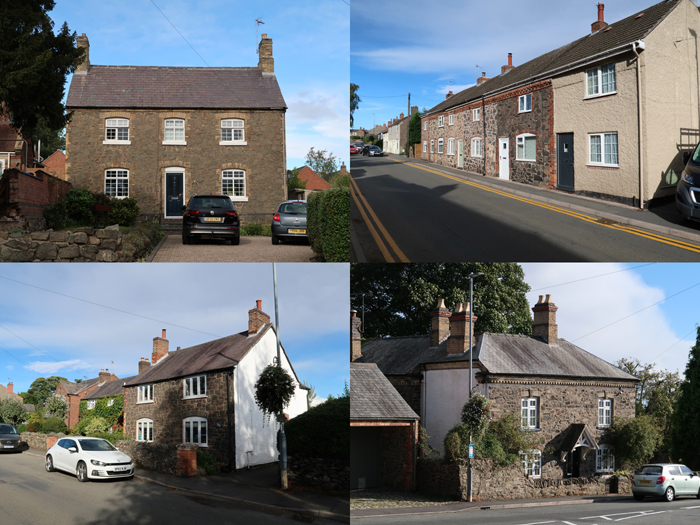
Vernacular architecture in Markfield

Friday 28 October 2022

The Shepherd Wheel to Hunter's Bar

 
An exposure of Greenmoor Rock beneath the roots of a tree

After a quick investigation of the geology along Porter Brook, just downstream of the Hangingwater Road bridge, I continued along the path to the Shepherd Wheel Workshop, to take a few photos of this very important example of Sheffield's industrial history for the British Listed Buildings website. 
 
The dam at the Shepherd Wheel

The two existing grinding hulls and the adjoining dam, goit and weir are dated c.1780 and, until c.1930, table and pocket knives were ground here. It is considered to be an outstanding example of the single process small scale units which characterised the Sheffield cutlery industry after the Industrial Revolution, but there has been a grinding hull on this site since c.1584. 
 
A general view of the Shepherd Wheel

I didn’t inspect the stonework here, but the source of the stone slates is the Rough Rock and for the walling stone it is quite likely to be the Loxley Edge Rock, which forms a substantial outcrop on the south side of the Porter Valley and was quarried at the nearby Greystones. 
 
Steps made from grindstones
 
Quickly making my way down to the end of Whiteley Woods and down through Endcliffe Park, I stopped very briefly to photograph the 'Mi Amigo' monument, which commemorates the crash of a B-17 Flying Fortress with the loss of 10 lives on 22nd February 1944. 
 
The 'Mi Amigo' monument in Endcliffe Park

Wherever the path passed near the Porter Brook, I had a look at the stream banks and although the streambed was covered with blocks of sandstone of various sizes, reflecting the underlying bedrock over which it has passed and eroded, I did not see any rock outcrops. 
 
Stepping stones on the Porter Brook in Endcliffe Park

Continuing along the path on the north side of the brook, I went to investigate the escarpment of Greenmoor Rock, where the soil had been eroded away to reveal small outcrops of flaggy sandstone that are visible beneath the roots of trees or are protruding from the ground. 
 
An outcrop of Greenmoor Rock in Endcliffe Park

The Greenmoor Rock varies considerably along its outcrop and I scrambled up the slope to obtain a sample for comparison with others that I had collected at Mushroom Lane, Graves Park and Parkwood Springs. It is a light brown/grey, very fine grained laminated sandstone, which quite unusually shows cross laminations at an angle to the bedding plane. 
 
A specimen of Greenmoor Rock from Endcliffe Park (21mm coin)
 
Arriving at Hunter's Bar, I went to have a close look at the former Yorkshire Bank building that I had passed many times on the bus, which appears to be an interwar alteration to a very late Victorian development where Junction Road and Ecclesall Road meet. 
 
The former Yorkshire Bank building at Hunter's Bar
 
This steel framed building is not listed, but its curved facade has cladding composed of three different types of granite, with a contrasting ‘black granite’ Art Deco style door surround and plinth and capital like details carved in relief at the top of the pilasters, is very pleasing to the eye. 
 
Granites and 'black granite'
 
Very near to the end of a productive walk, I photographed the last listed building on my itinerary, St. Augustine’s church on Brocco Bank, which was built in 1897 to a Gothic Revival design by JD Webster that uses what looks like Crawshaw Sandstone for the walling and Derbyshire gritstone for the quoins and dressings. 
 
St. Augustine's church

Walking clockwise around the church, I was very surprised to discover very stubby transepts that have been built with coursed and very irregular rubble masonry, which uses both a sandstone that is rusty brown in colour – as often seen during my investigation of historic buildings in Fulwood – and a thinly bedded rock faced sandstone. 
 
Masonry in the north transept
 
Having had a good look at various historic buildings that have used the Rough Rock, the Crawshaw Sandstone and the Loxley Edge Rock in their construction, this provided another stone identification puzzle at the end of a long walk, which I will have to further investigate at another time – along with the very unexpected exposures of Greenmoor Rock that are the remains of a quarry marked on the 1855 Ordnance Survey map.  
 
An old quarry exposure of the Greenmoor Rock

Wednesday 26 October 2022

Geology Along the Porter Brook

 
The Rough Rock downstream of the Hangingwater Road bridge

On the two previous occasions that I had walked along the Porter Brook, from Ringinglow and when exploring the area around Forge Dam with the Sheffield U3A Geology Group, I had seen various rock exposures that have been highlighted in the Porter Valley Geology leaflet by Peter Kennett of the Sheffield Area Geology Trust (SAGT). 
 
Flaggy Rough Rock exposed in the streambed of the Porter Brook
 
Between Hangingwater Road bridge and the Shepherd Wheel, the north-easterly dipping strata of the Rossendale Formation pass upwards from the Rough Rock sandstone to mudstones, a ganister at the level of the intermittent Pot Clay Coal seam and to the black shales of the Subcrenatum Marine Band – the designated boundary between the Upper Carboniferous Millstone Grit Group and the Coal Measures. 
 
Flaggy Rough Rock exposed in the streambed of the Porter Brook

When trying to get a good viewing point to photograph Hangingwater Road bridge, from the north side of the Porter Brook, I noticed that there were outcrops in the streambed and in the south bank that are very flaggy in nature. 
 
An exposure of flaggy Rough Rock

I returned to the bridge to take another record photograph and then just carry on downstream; however, having my Estwing hammer with me and plenty of time left in the day, I decided to go and further investigate the Porter Brook and see if I could obtain access to the exposures that I could see in the stream bank. 
 
A view downstream of Hangingwater Road bridge
 
Taking advantage of the low water level in the brook, I managed to cross over to the south bank – again jumping between the outcrops of flaggy sandstone in the streambed, as I had done only a few days earlier at Charlton Brook. 
 
An exposure of Rough Rock in the south bank of Porter Brook

I very quickly explored a section of the stream bank, where the Rough Rock is exposed. At its western, the lowest beds are highly laminated and very fine grained and pass upwards into more massive sandstone, where individual beds are occasionally more than 200 mm thick. 
 
An exposure of massive and laminated Rough Rock

I obtained three small samples of the Rough Rock from this outcrop. The specimen from the higher, more massive beds is a very fine grained pale grey/brown sandstone, with some orange iron staining in the body of the rock and very fine black iron bearing minerals scattered throughout. Within the body of this sandstone, laminations are clearly visible and, as seen on an exposed bedding plane, these contain a moderate amount of muscovite mica. 
 
A sample from the massive beds of the Rough Rock (21mm coin)

Of the two samples taken from the lower beds, one has a greater degree of lamination and higher silt content than the massive rock, but its colouration and mineralogy are quite similar. The second sample has the same general characteristics, but has internal laminations that are much darker in colour and particles of a much finer grain size. 
 
Samples from the laminated beds of the Rough Rock (21mm coin)
 

Sunday 23 October 2022

A Walk Along the Porter Brook

 
The road bridge at Hangingwater Road

Arriving at the bridge over the Porter Brook on Woodcliffe, less than 100 metres downstream from its confluence with the Mayfield Brook, the first thing that I noticed was the deep orange colour of the river bed – the result of the microbial weathering of iron minerals in the shales between the Redmires Flags and the Rough Rock. 
 
Ochreous deposits on the riverbed of the Porter Brook

Having spent just over two hours exploring and photographing historic buildings in Ranmoor and Fulwood, this reminded me of the geology that I would encounter, when following the course of the Porter Brook down to Hunters Bar – based on my experience of previously walking down from Ringinglow and exploring the area with the Sheffield U3A Geology Group. 
 
The bridge over the Porter Brook at Woodside

Quickly walking down past Forge Dam, I took a diversion past various stone built remains of goits and sluices to find the Grade II Listed monument to Thomas Boulsover, which was built in 1929 on the north side of Wire Mill Dam. 
 
Miscellaneous structures along the Porter Brook

Although a photo had already been contributed to the British Listed Buildings website, I was interested in seeing this monument to the creator of Sheffield Plate. Having passed the sculpture by Richard Perry outside the central library in Sheffield very many times, which I know more for the green staining to the Portland stone plinth than Thomas Boulsover himself, I wanted to learn a bit more about Sheffield’s industrial history. 
 
The Thomas Boulsover monument
 
Stopping briefly to photograph the Grade II Listed No. 8 and Nos 4 and 6 Ivy Cottages, where the overall character of the walling stone looks quite different and contrasts with the bricks used to build No. 2, I continued east along the path that runs beside the brook.
 
Views of Ivy Cottages

The Porter Brook has cut down through the Pennine Lower Coal Measures Formation into the Rough Rock here, which is exposed by the constant flow from a spring on the south side of the valley and where generally flaggy beds are clearly seen. 
 
A small exposure of the Rough Rock
 
Continuing along the path to the Hangingwater Road bridge, built c.1800, I stopped to take a few more photographs for the British Listed Buildings website, before going to investigate the various rock exposures in the river bank downstream. 
 
The east elevation of the Hangingwater Road bridge

I immediately encountered another extremely ochreous small tributary stream – this time probably related to the drainage from shallow coal mine activities, with microbial weathering of the mineral pyrite that is often associated with coal seams.
 
An ochreous tributary of the Porter Brook

Friday 21 October 2022

Historic Buildings in Fulwood - Part 3

 
Fulwood Hall

Continuing my investigation of the historic buildings in Fulwood, to look at their building stones and to take photographs for the British Listed Buildings website, I had by now reached the open countryside – with views across the upper reaches of the Porter Valley to Ringinglow. 
 
A view of the countryside between Fulwood and Ringinglow

The high ground on which I was standing and that on the horizon is underlain by the Rough Rock, with the Porter Valley and Mayfield Valley being cut through this into the underlying mudstones and siltstones of the Rossendale Formation and the sandstone of the Redmires Flags. 
 
The geology around the upper Porter Valley
 
I carried on along School Green Lane to Harrison Lane, where I could only get limited views of the rear elevation of Fulwood Hall (1620) from over the boundary wall adjacent to the roadside, along with its extensive outbuildings. 
 
Views of Fulwood Hall

From the road, I could see enough to determine that the walling stone, comprising relatively thin courses and containing a significant of dark rusty brown blocks, is probably another example of the Rough Rock. The source of the stone is likely to be the Brown Edge Quarries, which are less than 2.5 km away as the crow flies. 
 
A window with mullions and transoms at Fulwood Hall
 
The quoins and dressings, which include windows with mullions and transoms  that are typical of the Jacobean period, are made of massive, very coarse sandstone that is very probably the Chatsworth Grit and which would have been brought from one of the quarries on the south side of the Rivelin Valley a short distance to the north. 
 
Stone slates at Fulwood Hall

The most impressive aspect of Fulwood Hall and its ancillary buildings are the roofs, which which are all covered in very large and thick stone slates that show very little signs of deterioration. The flaggy nature of the Rough Rock around Sheffield made it ideal for this purpose and also for flagstone paving, examples of which I have not yet knowingly seen. 
 
Hole in the Wall Farm

Walking down David Lane, I soon came across one of the barns that forms part of the Hole in the Wall Farm, where the building materials are the same as those used in Fulwood Hall, but I couldn’t see any part of the main building and only got a glimpse of it from a distance later on my walk. 
 
West Carr Cottages

At the bottom of David Lane, the late C18 West Carr Cottages provide a further example of the Rough Rock being exploited for both stone slates and deep coursed walling stone, with the latter being obtained from more massive beds in the quarry but, with little else to see, I quickly carried on to the adjoining former Fulwood Board School. 
 
The former Fulwood Board School
 
Built in 1878, it is the simplest design by CJ innocent of Innocent and Brown, without any of the flourishes seen at Manor Board School, which was built only two years earlier. It includes a teacher’s house and was designed to accommodate 131 children, which is rather surprising when looking at the low density of population in the surrounding area. 
 
A general view of the front elevation and boundary wall
 
As with all of the historic buildings that I had so far seen, since walking from the Ranmoor Council School, I didn’t spend any time closely examining the various sandstones; however, standing back to take a general photograph of the front elevation, I could clearly see differences in the colours and textures of the sandstones used in the school itself and the various original and recently built boundary walls. 
 
The north gable end of the former Fulwood Board School
 
Most of the 39 board schools that I have visited are, I think, built in Crawshaw Sandstone from the Bole Hill quarries in Crookes/Walkley. Its principal characteristics are its uniform pale buff colour, distinctive planar bedding, medium grain size and limited bed height of the coursed stone and, unless the stonework is very dirty, these can be recognised.
 
The teacher's house

Looking at the lowest courses of the teacher’s house, the sandstone is more massive and contains distinct Liesegang rings and the rest of the sandstone, although planar bedded and in many ways similar to the familiar Crawshaw Sandstone, contains several blocks with dark rusty brown concentrations of iron oxides/hydroxides. 
 
A new section of wlling at the former Fulwood Board School

For such a small school in a remote location, perhaps the use of local Rough Rock might have been a prudent measure – especially since the Sheffield School Board had been cutting costs – but the use of Crawshaw Sandstone with Stoke Hall stone seems to be a near constant design feature of the schools. 
 
The Mayfield Wesleyan Reform Chapel

After having a quick look at the Mayfield Wesleyan Reform Church (1896), I made my way along Mayfield Road where I stopped to photograph the Grade II Listed Carr Houses and a converted barn to the north-east of it from a distance, before walking down to the Porter Brook. 
 
Listed buildings seen from Mayfield Road