Sunday 30 June 2019

A Reconnaissance of Monsal Dale


Specimens of tufa collected during the day

When undertaking the reconnaissance of Monsal Dale for the Sheffield U3A Geology Group field trip in April 2019, Hob’s House – with its landslips and spectacular coral bands – was considered to be the most interesting site that we would see during the day. 

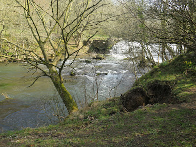
A large weir on the River Wye

With the objective of the Group’s trips to also provide a good walk of 4 to 5 miles, we had to try and find other points of interest that might include some industrial archaeology, which is also a feature of Monsal Dale, like many others in the Peak District

An exposure of tufa revealed by a fallen tree

Just downstream from the large weir on the River Wye, a tree on the river bank has partially fallen, with its roots having pulled away the subsoil to an exposure of tufa with concretionary structures, along with fine carbon rich layers. 

An exposure of alluvium in the river bank

With this unexpected discovery, which would occupy the group for a reasonable amount of time, the small floodplain just downstream on the opposite bank was considered to be a good place for a lunch stop, before investigating the river bank.

Partially cemented coarse sand overlain by silt

The river bank here has been reinforced with gabions in places, to prevent excessive erosion, and a section of the bank also exposes partially cemented coarse sand deposits that are overlain with alluvium that contains a high proportion of silt, with angular fragments of limestone. 

Riffles in the river bed

Continuing further downstream, there is virtually no exposure of limestone, although riffles in the river bed are very common, and several springs emerge from the lower slopes, which are associated with tufa that forms terrace like features. 

An exposure of tufa in the river bank

Approaching Lees Bottom near to the A6 road, the Lees Bottom Lava Member underlies the lower slopes and, although there is no outcrop of the basalt to be seen, its presence is indicated by a large expanse of boggy ground and several streams that flow over the impermeable rock. 

A stream flowing on the Lees Bottom Lava Member

The return journey to Monsal Head was undertaken via the farm at Brushfield Hough and an old lead rake known as the Putfield Hill vein where, in places, waste tips contain various specimens of calcite and barytes. There are no outcrops of limestone to be seen on this leg of the walk, but the dry stone walls contain concentrations of brachiopods and there are good views of Fin Cop, upon which there is an Iron Age hillfort

A view of Fin Cop

On the descent back into Monsal Dale, the slopes upstream of the viaduct are not covered in dense woods and the development of the scree slopes here can be quite clearly seen, together with exposures of Monsal Dale Limestone that are dipping to the south-east. 

An exposure of Monsal Dale Limestone and a well developed scree slope

In the well worn and eroded path, limestone bedrock and loose irregular blocks are exposed in the path and there there are several well rounded boulders of basalt, which are some distance from the nearest outcrop of volcanic rock and must therefore have been deposited here during the Quaternary Period – either by an ice sheet or by fluvioglacial processes. 

Large boulders of basalt

Our reconnaissance of Monsal Dale finished by crossing Headstone Viaduct to briefly look at the entrance of the Headstone Tunnel, where there is an extensive outcrop of Monsal Dale Limestone, and then carrying on up the steep path up to Monsal Head. 

The entrance to the eastern section of the Headstone Tunnel

Often with moderately demanding slopes and, taking the gradients into account, the walk was over 8 km, and have to admit feeling very tired at the end of the day. In an ideal world, I would have taken advantage of the Monsal Head Hotel – relaxing in the late afternoon sunshine with a pint of real ale – but unfortunately my companion for the day had to get back home.

An exploration of Monsal Dale

Saturday 29 June 2019

A Reconnaissance of Hob's House


Solitary corals in the Hob's House Coral Band

During March 2019, I investigated Selby Abbey, mediaeval churches in the villages of Baslow, Stoney Middleton and Silkstone, as well as visiting Poole’s Cavern in Buxton, and I finished off the month by assisting with the reconnaissance of Monsal Dale – in preparation for the next day out with the Sheffield U3A Geology Group

The geology around Monsal Dale

The plan was to firstly investigate Hob’s House, a site that is of interest to geologists for its landslips and the fossils that it contains. Secondly, we would then try and find the basalt that is marked on the British Geological Survey map, as well as identifying other points of interest on a circular walk of more than 8 km. 

A view down down Monsal Dale from Monsal Head

Arriving on a cool Saturday morning, when a mist still hung over the various valleys that we encountered after leaving Sheffield, we easily found a parking space on the road from Little Longstone and started off at the usual time of 10:30 am. 

A view of Hob's House from Monsal Head

So I was told by my colleague, he had been to Hob’s House with the group before but, when walking down the well-trodden path from Monsal Head to the valley bottom, a local explained that a high level path had long become overgrown and that the Duke of Devonshire had been erecting fences to prevent access to Hob’s House, where it was considered unsafe. 

Vegetated scree below Hob's House

Not being able to see any kind of path by the time we had reached the large weir on the River Wye, we attempted to scramble up over a heavily vegetated scree slope, but both of us had potentially injurious slips in the attempt and had to retreat. 

A barbed wire fence below Hob's House

Our next effort, also by an undefined path, took us to a barbed wire fence that had been previously described to us and, by this time, I was beginning to curse my companion who casually slipped under this fence. Whilst I admired his tenacity at the age of 70, a risk assessment for undergraduate geology students would have been rated as high and, for a group that has membership of an average age of 70+, it would have been well off the scale. 

A cleft in the limestone at Hob's House

Finally arriving at Hob’s House landslip, which comprises a series of very large blocks of Monsal Dale Limestone Formation separated by wide clefts, I have to admit that the climb was well worth it, but we agreed that another route to the site would need to be found for the group.

Chert nodules and solitary corals

Although the rough, blocky terrain of the scree need to be carefully traversed, the irregular, nodular beds of chert and the Hob’s House Coral Band are spectacularly exposed here. The latter is about one metre thick, with a lower leaf rich in the small colonial forms Diphyphyllum and Lithostrotion and an upper leaf with large solitary corals, particularly Dibunophyllum.

The Hob's House Coral Band

Unlike those most often seen in the Carboniferous limestone, the fossils here have been silicified and differential weathering between them and the surrounding limestone has left the corals standing proud of the surface, with the fine details exceptionally well preserved. 

A solitary coral

Having had a good exploration of the various rock faces, a large rotated block of limestone, and the scree slope above Hob's House we then set off to find our way back down to the main path from Monsal Head. 

A rotated block and the scree slope above Hob's House

Although not very well defined, it was obvious from disturbed vegetation that the route we followed was used by others and, when later eating lunch in the valley below, we saw a few people in the area where we had been less than half an hour earlier.

The start of the route down to the valley floor

Saturday 22 June 2019

All Saints Silkstone - The Interior


A detail of the monument to Sir Thomas Wentworth

Entering the interior of All Saints church in Silkstone, the first impression is that the arcades are uniform in style, just like the exterior, and there are no changes to the pattern of the masonry to the walling, which would indicate various phases of building.

A view to the east along the nave

Pevsner considers that the current Perpendicular Gothic church replaces one of c.1200, which had a central tower, and that the circular columns to the arcades are reused from the earlier structure – as is also seen at Ecclesfield and High Bradfield in Sheffield.

A view to the west along the nave

Looking closely at these, the sandstone in the uppermost drum of the columns, the octagonal section capitals and the moulded blocks of the arches lacks the slight orange/red colour variation seen in the general walling above them.

A general view of the north arcade

The provenance of the sandstone used in the church is not known but this variation could be attributed to the use of the best beds in the quarry for the columns and arches, with inferior quality stone used for the masonry that would be subsequently plastered.

A detail of an impost to the tower arch

The only elaborate decoration appears on the imposts of the tower arch, which again reminded me of the church of St. Nicholas in High Bradfield and also St. Michael’s church in Hathersage, both of which are strongly Perpendicular Gothic style in character.

A round arch at the entrance to the chapel of St. James

Entering the rebuilt chancel, there is more evidence of the late Norman church with the round arch to the St. James Chapel that, together with the adjacent walling, is the last remnant of the original crossing tower.

The monument to Sir Thomas Wentworth and his wife Grace

The Bretton Chapel contains a spectacular monument to Sir Thomas Wentworth, d.1675, and his wife Grace, d.1698, that is made of lightly veined white Carrara marble for the effigies and veined black marble for the tomb chest. These, and the side panels, depict the clothes, armour, weapons and other accoutrements that are typical of the time of the  English Civil Wars.

A side panel on the monument to Sir Thomas Wentworth

As usually seen in mediaeval churches, several Neoclassical wall memorials provide further examples of black and white Italian marbles, but the Victorian font particularly caught my eye, with its use of various "marbles" from Derbyshire, Ashburton in Devon and Co. Cork in Ireland.

Various "marbles" in the font

Friday 21 June 2019

Grotesques at All Saints Church


An angel

As a photographer, I first developed my skills when taking ‘before and after’ photos when publicising the work of Triton Building Restoration Ltd. and, taking advantage of working high up on a scaffold, I quickly learned that close up shots of architectural details attracted the attention of potential customers.

A grotesque at Nyman's Gardens in West Sussex

For personal reasons, I had to leave this lucrative business, but my next venture into black and white photography led to a brief from the Royal Commission on the Historical Monuments of England (RCHME), to take as many photographs of post-war architectural sculpture that I could find and which led to other work for the National Inventory of War Memorials and membership of the Public Monuments and Sculpture Association (PMSA).

A grotesque at Trinity Church on Ecclesall Road in Sheffield

This temporary project was never going to earn me a living - paid at the rate of £10 per print – but it sharpened my practical skills and opened up my eyes to a range of other possibilities relating to the visual arts. Also, being encouraged to record war memorials and all kinds of public sculpture, I have photographed these subjects ever since and during my investigation of mediaeval churches, I like to see gargoyles and grotesques.

Finials and grotesques on the north aisle

At All Saints church in Silkstone, there is a spectacular set of 23 grotesques that form part of the short flying buttresses, which link tall finials to the aisles. The buttresses serve no obvious structural purpose and are used purely for decoration – as also seen on the porch and parts of the south aisle at St. Mary’s church in Ecclesfield.

A bat

In the poor light, I only took a few quick snaps of these grotesques, which include a bat, a ram, other strange chimera like creatures and various male and female human forms. They include original mediaeval carvings - some of which are that are eroded beyond recognition - Victorian restorations and modern replacements, carved in 2005, which depict a local businessman, a churchwarden and the mayor of Saint-Florent-Des-BoisSilkstone's twin town in France.

Modern grotesques carved in dolomitic limestone

The latter are carved in dolomitic limestone from Cadeby, which reflect the use of similar stone in several original grotesques, which are now so weathered that they have lost all detail and it is not possible to determine their form. The use of dolomitic limestone is quite unusual, given that the nearest outcrop is nearly 20 km to the east, and that sandstones suitable for intricate carving could be found much nearer.

Heavily weathered grotesques

Other grotesques that seem to be original appear to be made of sandstone, although it is not easy to confirm this without close examination with a hand lens; however, those that were renewed during the restoration of 1875 are obviously sandstone, with a blackened appearance that is typical when this stone is very exposed to the weather – especially when there has been atmospheric pollution from local industry.

Various figurative sculptures from the 19th century

At some time, on a sunny day, I will return to All Saints church to take some better photographs of these magnificent stone carvings and to take a closer look at the various building stones that have been used for the grotesques and the church as a whole.

Mythical creatures

Monday 17 June 2019

All Saints Church in Silkstone


The south elevation of All Saints church

Alighting from the No. 20 bus from Barnsley, at the north-east corner of its churchyard, the approach to the east end of the church of All Saints and St. James the Greater is up a hill that is a product partly of a fault with a downthrow to the east-south-east and by a valley formed within the Silkstone Rock by Silkstone Beck.

A general view from the south-east

Getting nearer to the church, my first impression was that the sandstone used to build the entire mediaeval structure is very uniform in both its colour and texture. Even on an overcast day, the walling stone appears quite yellow and the cross-bedding is differentially weathered to give a very distinctive character.

The east elevation of the chancel

The stone for the chancel, rebuilt 1857/58, is similar to that used in the mediaeval work and I assume that it has all been quarried from the same source. Looking very closely at the masonry, especially at the very large blocks used in the plinth, much of the sandstone has a coarse grained character that is typical of sandstone from the Millstone Grit but not the Coal Measures.

A detail of the yellow colouration and cross-bedding

When later looking at buildings in the village, I came to the conclusion that the bulk of the material used in the church was not quarried locally. Although I don’t know its source, during previous investigations of historic buildings in West Yorkshire, I have encountered sandstones with a similar texture that I thought might have been Woolley Edge Rock, but this needs further investigation.

The porch

Walking quickly around the church to take some general photos, the description by Pevsner as "appearing all Perpendicular" is reflected in the style of the windows on both sides of the church – in the aisles and clerestory.

A general view from the north-west

The aisles, and the St. James and Brampton chapels, have four centred arches with simple foils, which are considered to be typical of the late mediaeval period – up to c.1500 – and the flat headed windows to the clerestory are in the same style.

The chapel of St. James on the north elevation

The official guide to the church states that the last phase of mediaeval building ended with the completion of the tower in 1495, with which the Historic England listing agrees, and the castellated parapets and crocketted finials provide further indication of the late mediaeval date.

A general view from the north-east