Sunday 31 January 2021

An Investigation of the Shire Brook


The Shire Brook in Wickfield Plantation

Having encountered various historic buildings in Intake, while walking down Mansfield Road, I continued up Hollinsend Road to Jaunty Park, where I started out on the main purpose of my walk – to try and find some geology along the section of the Shire Brook that runs from Hollinsend down to Normanton Spring.
 
A panoramic view of Jaunty Park

Walking across some often wild grassland into the valley formed in the Pennines Lower Coal Measures Formation, I turned round to look at the escarpment of Parkgate Rock, which here is cut by a fault with a downthrow to the north side.
 
Arriving at the Shire Brook, the banks were largely overgrown with thick undergrowth and I couldn’t see anywhere likely to have rock exposures. As with the upper parts of Shirtcliffe Valley, where I found a coal seam, the streambed was littered with blocks of stone, bricks and other materials from the Birley Vale Colliery, which was once located on the east side of the brook.
 
The streambed of the Shire Brook

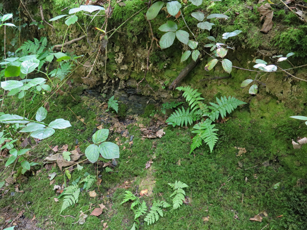
I quickly walked down the path to Mansfield Road/Birley Moor Road where, just before it passes under the road, there is a large area of red ochre stained boggy ground, which had by now become a familiar sight during my investigations of various woods around Sheffield.
 
Ochreous staining in the Shire Brook

On the other side of the road, the path runs alongside a secure fence and, as I again later discovered, the brook is culverted here and the fenced off area is part of the former Birley West Colliery and the subsequent Normanton Spring landfill site - both of which are now restored.
 
Industry around the Shire Brook in 1906

Crossing Linley Lane and entering Wickfield Plantation, I finally found some rock outcrops in the streambed and banks of the Shire Brook, which once formed the boundary of the ancient kingdoms of Mercia and Northumbria and later between Derbyshire and Yorkshire.
 
A view down to the streambed of the Shire Brook

The thinly bedded sandstone here is the same one that I encountered at the roadside cutting at the bottom of Normanton Hill, with the bedding planes and an irregular pattern of oblique jointing being exposed along the streambed.
 
The streambed of the Shire Brook

Old maps show a disused quarry to the south side of the brook, but I kept to the footpath and didn’t see any evidence of this. The stone would have been used mainly for basic walling and, although flaggy, paving stones or stone roof tiles could probably not be produced commercially from this sandstone quarry.
 
Iron stained sandstone with irregular jointing

In places, the sandstone is fine grained with a rusty brown iron staining and is similar to that seen in the outcrop on Richmond Road and, although not developed here, the strata between this and the Vanderbeckei
(Clay Cross) Marine Band in the Barnsley District contain once economically important ironstones.
 
Various building materials in the streambed

Following the course of the brook further downstream, large tracts of the streambed are dominated by old building stones and bricks – reflecting the industrial history of the area – but dark grey siltstone and weathered mudstone can occasionally seen in the banks.
 
Mudstone in the stream bank

Leaving the woods, I then quickly made my way back up through Richmond Park, where the position of the Vanderbeckei Marine Band - the boundary between the Lower and Middle Coal Measures - approximately coincides with a small diverted stream that cuts into the relatively soft underlying rocks here.
 
A panoramic view towards Normanton Spring

Walking up the path, to the left is the long dip slope that forms the part of Richmond Park to the north side of Normanton Hill and, to the right, an escarpment rises up to the blocks of flats on Stradbrook Road.
 
A view across the Vanderbeckei Marine Band

Finally arriving back on Richmond Road, I had half an hour before the No.73 bus arrived to take me back to Treeton. Having been shut during COVID-19 Pandemic lockdown, the Richmond Road public house was now open but, not wishing to spend time amongst the crowd that was gathered outside, I bought a cold beer from the Co-op and quenched my thirst at Woodthorpe Fishond.

A cold beer at Woodthorpe Fishpond

Saturday 30 January 2021

Historic Architecture in Intake - Part 2


A gable end at Intake Primary School

In 1855, the Ordnance Survey map of Intake shows that it is a small hamlet at the junction of the roads to Mansfield and Handsworth, with various small coal pits, sandstone quarries, coke ovens and Woodthorpe Colliery appearing in a predominantly rural area.

The 1855 Ordnance Survey map of Intake

From c.1800 to the beginning of World War I, the population of Sheffield grew exponentially to accommodate the growth of the production of steel and associated manufacturing and engineering industries and the 1894 map shows that Intake had grown considerably, with the Birley Collieries now requiring houses for their workers.

The 1894 Ordnance Survey map of Intake

Continuing with my investigation of the historic architecture in Intake, I arrived at the entrance to Intake Cemetery, where the Grade II Listed lodge, dated 1879, has an unusual square wooden bell turret and a pyramidal roof with a finial.

The lodge at Intake Cemetery

The lodge, which reminds me of the Kiveton Park colliery offices that I had seen a few weeks earlier during my walk from Harthill to Todwick, and the nearby chapel were built by Innocent and Brown - an architectural practice that I had never heard of before.

The chapel at Intake Cemetery

Undertaking further research into this practice, I have discovered that they also designed the nearby Woodhouse Cemetery chapel, in a similar style, a year earlier and that they were also responsible for the design of many schools for the Sheffield School Board, following the 1870 Education Act.

The terrace of houses adjacent to Intake Cemetery

Immediately to the south of Intake Cemetery, a terrace of six houses is first shown on the 1924 map, with the Fidler Bros memorial masons at No. 89 being established in 1908. This and No. 91 have a different design to the other houses in the terrace and, as also evidenced by the lack of bonding between No. 91 and No. 93, it would seem that the standard design terraced houses were added to the pre-existing semi-detached house at a later date.

89 and 91 Mansfield Road

I didn’t closely examine the stonework of any of these with a hand lens, but subtle differences can be seen in the colouration of the sandstone used in these houses. Some have been cleaned or repointed with different styles and compositions of mortar, which affects the general appearance of the masonry as a whole, but to my eye there are noticeable variations in the individual stones.

'Ginger nut' hued sandstone at Rheidol Cottage

For most vernacular buildings, local stone is almost invariably used and these usually give a good indication of the characteristics of the underlying sandstone and most of the stone that I saw in Intake was generally similar; however, Rheidol Cottage stands out because it is built in thin courses of ‘ginger nut’ hued sandstone, which is typical of Handsworth, and looks very different to the one used at No. 89.

Intake Primary School

Across the road from the cemetery, Intake Primary School was built in 1888 for the Handsworth School Board, by an unknown architect, and uses a grey/light brown laminated sandstone for the general walling, with massive medium grained sandstone used for the dressings.

Rotherham Red sandstone in a window jamb

Again I didn’t stop to closely examine the various sandstones used here but, at one point, I couldn’t help but notice that the distinctive pink/mauve Rotherham Red sandstone has been used for some of the window dressings and the plinth course. It looks very much like the stone seen at the old vicarage and St. Joseph’s Catholic church in Handsworth, where the latter is recorded as having used Treeton stone from Bole Hill.

Rotherham Red sandstone window dressings

Carrying on down Mansfield Road, I then crossed back over to the junction with Hollybank Road, from where I could get a good a view of the vale in the middle. This is formed in the prefominantly soft mudstones of the Pennine Lower Coal Measures Formation, which then rises to the sandstone escarpment that I had followed down Normanton Hill.

A view along Hollybank Road to Normanton Hill

Crossing back over Mansfield Road and then heading up Hollinsend Road to find the path to the Shire Brook, I came across the Wesleyan church, dated 1858, which provides another example of what I presume to be locally quarried Parkgate Rock.

Hollinsend Wesleyan chapel

Friday 29 January 2021

Historic Architecture in Intake - Part 1


A detail of Intake Primitive Methodist Church

At the end of week 18 of the COVID-19 Pandemic travel restrictions, in the third week of July 2020, I had fallen into a pattern of doing essential shopping in midweek or on a Saturday and then taking some essential exercise on a Sunday.
 
The route of the walk

For my next trip to investigate the geology, historic buildings and industrial history of the area within a ‘safe’ distance from Treeton, I identified on Google Map another part of the Shire Brook that I had not yet explored.
 
Taking the No.73 bus to Manor Top, I started by walking down Mansfield Road with the Parkgate Rock forming the high ground to my right, which I could see from the top of Hollybank Road during my previous investigation of Normanton Hill.
 
A view down Mansfield Road

Manor Top forms one of the highest points on the Sheffield ring road, with good views, and in the distance can be seen the high ground beyond the M1 motorway to the south-east, which is formed by the Pennines Middle Coal Measures Formation strata – in particular the Mexborough Rock.
 
Intake Primitive Methodist Church

At the junction with Foxwood Road in Intake, the former Primitive Methodist Church here - originally built in 1874 - was enlarged in 1886, with pitch-faced laminated sandstone used for the walling and a more massive sandstone used for the dressings. It is not a listed building or mentioned by Pevsner, but it nonetheless has some interesting architectural features.
 
A detail of the stonework to the left gable

The masonry has been partially blackened but its greyish colour, with rusty coloured Liesegang rings and dense brown accumulations that formed along joints, can be clearly seen. These characteristics are apparent in both the walling and dressings and it is very probable that they came from different beds within the same quarry.
 
The 1855 map of Intake

As with most building stones, unless they possess very distinctive physical characteristics that make them easily recognisable, without documentary evidence it is extremely difficult to pinpoint a quarry source. Also, as I had recently discovered at St. James' church in Woodhouse, with the coming of the railways, stone could brought be brought in from a considerable distance.
 
Various Victorian houses on Mansfield Road

On the 1855 map, a sandstone quarry is marked just to the south of the site of the future church. It is included in the national Directory of Mines and Quarries of 1897 and recorded in the Whites Directory of Sheffield & Rotherham, which suggests that it was a well established business.
 
Intake Villa

Between 1855 and 1894, various terraced, semi-detached and detached houses were built along Mansfield Road, including Intake Villa in 1878. The latter has laminated sandstone walling stone, which is very probably local, but the pinkish massive sandstone used for the quoins is not typical of those found in the area.
 
An inscription at Intake Villa
 

Wednesday 27 January 2021

A Coal Seam in Smelter Wood


An exposure of coal

When I first visited the Shitcliffe Valley at the beginning of June 2020, I was informed by Pat Howells of the Friends of Shirtcliffe that the valley was once mined for coal and a small outcrop could still be seen in Smelter Wood.
 
Sites of collieries in the Shirtcliffe Valley

Drift mines at Smelter Wood, Bramley Hall, Bramley Hall No.2 and the Vicar Lane colliery exploited the Swallow Wood coal seam, a bituminous coal, which was economically important in the region and, at Bramley Hall, the underlying fireclay was also worked for refractory ware.
 
The Swallow Wood (SW) coal seam in the Shirtcliffe Valley

Having had a good look at the sandstone in the area of the valley known as The Edge, I carried on along the escarpment and, not referring to the map with me, I didn’t notice the site of the old sandstone quarry marked on the 1855 map, which is shown as a plantation on later editions.
 
A view of Smelter Wood from The Edge

Descending from The Edge and following the main path into Smelter Wood, I eventually came to Shirtcliff Brook, where the sewage pipe forms a recognisable landmark that I had encoutered during my previous visit.
 
The sewage pipe in Smelter Wood

The map that I had been given showed the position of the coal to be just to the north of the stream crossing here but, before I went to find it, I investigated the rock exposures that I could see in the streambed and banks.
 
Siltstone in the stream bed of Shirtcliff Brook

In places, the streambed is formed of exposed bedding planes of grey siltstone, with iron staining, and this can also be seen projecting from the banks at water level. The grey colour is similar to the siltstone seen earlier in the walk and in some of the poor quality walling stone at St. Mary’s church and in various boundary walls in Handsworth.
 
A view along the streambed
 
The streambed is also littered with various fragments of various shapes, sizes and colours and, in addition to examples of the underlying bedrock, this includes brick, concrete and miscellaneous building materials that are probably associated with the former drift mines here.
 
A mossy bank alongside the main path

Returning to the main path and following the brook upstream, if I hadn’t been given information on where to find the coal seam, it is quite likely that I would never have found it; however, the bank alongside the path had a covering of moss that caught my eye and, looking very closely at this, I found a very small exposure.
 
A small exposure of coal

At first, examining a few loose fragments that were lying below this exposure, which made me wonder if someone else had recently uncovered this, I thought that it might be a dark mudstone or shale of the type that I had encountered in the banks of the River Rother during my investigation of the Waverley Estate.
 
A detail of the coal exposure

Using my stainless steel knife to collect some small samples and my hand lens to examine them, I could confirm that it was in fact coal, albeit a poor quality coal that the miners used to call dirt and which is recorded as alternating with the coal seams in both of the Bramley Hall collieries on pp. 97-98 of the Sheffield memoir.
 
The coal mining industry was once the backbone of the UK economy and, as I have discovered during my local walks during the COVID-19 Pandemic lockdowns, the landscapes of South Yorkshire have been greatly affected by this.
 
Samples of coal from Smelter Wood

During the very many site surveys that I have undertaken over the years in South Yorkshire, I had previously encountered coal seams only at Bradgate Brickworks and Loadfield Quarry, with others along the Clowne Greenway in Derbyshire and underground at the National Coal Mining Museum in West Yorkshire.
 
Specimens of coal from my rock collection

The outcrop in Smelter Wood might not be very spectacular but, as a very rare example of a readily accessible coal seam that is very likely to be soon enveloped by the surrounding undergrowth, it has great conservation and educational value and I was glad that I made an effort to go and find it.