 |
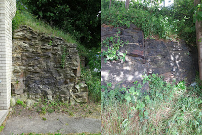
| Coal Measures sandstone at Sea Breeze Terrace |
The Carboniferous limestone retaining wall at the top of Normanton Hill provided a good start to my COVID-19 walk from Richmond back to Treeton and, although now largely overgrown, there is a small exposure of Pennine Lower Coal Measures Formation sandstone on the opposite side of Richmond Road.
Except for the spectacular scenery in the Peak District National Park and various limestone gorges in the east, there are very few extensive rocky landscapes in South Yorkshire. The bedrock geology is generally only well exposed in stone quarries, brick pits and in various road and railway cuttings and, as such, accessible outcrops such as this possess considerable scientific and educational value.
Local authorities have statutory obligations in respect of geological conservation but, in practice, funding is not even available to maintain RIGS or similar sites - except if funded by a developer as at Green Moor – and unrecorded exposures like this will just disappear.
Noting the wedge bedding, spheroidal weathering and its high iron content, which is very evident on the exposed joint planes, I then carried on down Richmond Road to the modern church of St. Catherine of Siena – designed by Sir Basil Spence.
This is set on one of the mudstones that separate the sandstones marked on the geological map between Normanton Hill and Handsworth and, looking back, the 9 degree angle of the dip slope marked on the map is clearly discernable here.
Continuing along Richmond Road, the scarp and vale topography of the Pennine Middle Coal Measures Formation strata is again quite obvious, but the surrounding landscape is obscured by the predominantly inter-war housing estates that have been built alongside this road.
I am a great advocate of urban geology and, keeping my eyes on the various stone walls and old houses that I could see along the way, the highlight of my walk to date must be the pair of gate piers at the entrance to a small block of modern flats.
Marking the entrance to the former Gray's Farm, they have been dated by English Heritage to c.1700 and are described as being “Ashlar, Round piers with vermiculated rustication, with ball finials on long necks”.
Apart from the intricate stone carving, which is normally reserved for buildings of high status, the sandstone itself contains very many weathered iron nodules – from pebble to small cobble size – that are characteristic of the Coal Measures strata of this age in South Yorkshire and there is a good example of honeycomb weathering too.
Looking at old maps, a few old quarries are marked in the area, with the largest being to the north of the old village of Handsworth but, without any supporting documentation, I can only make a guess at the provenance of these various sandstones.
Although, as a geologist, I am writing this Language of Stone Blog to appeal to anyone who shares my interests in stone in its may forms, much of my professional work has been concerned with the surveying and restoration of historic buildings – and I particularly liked the brick built Wesleyan Reform Chapel.
Passing the delightfully named Sea Breeze Terrace, which is built in a sandstone where the finely laminated beds are clearly seen and has in places what I would call a “ginger nut” hue, I walked up and down a few more slopes before arriving at the bottom of the escarpment upon which St. Mary’s church in Handsworth is situated.
I didn’t stop to look closely at any of the mainly terraced houses around here, all of which are built in a similarly coloured sandstone, and quickly made my way up the escarpment and passed by the water trough and the war memorial, which I had already photographed a few times, before continuing towards St. Joseph’s Catholic church.
 |
| A view up the escarpment to Handsworth |


No comments:
Post a Comment