Thursday 22 October 2020

The COVID-19 Pandemic


A COVID-19 slogan

The spring of 2020, after an extremely wet winter, had started very well with a good walk in the Peak District National Park and trips to Charnwood Forest and Clowne, with Paul May, to prepare for the Sheffield U3A Geology Group field trips for March and April.

An illustrated talk

In the last week of March, I had an illustrated talk at St. Peter’s church in Edensor and a guided tour of St. Helen’s church in Treeton to look forward to and, although not until September, Sheffield Libraries had asked me to give another talk on the theme of Exploration – after seeing some of my photos of gargoyles on Twitter.

Places visited in 2019

Having managed to organise more than 50 days out in 2020, travelling to places no further than 55 km from Treeton as the crow flies, using buses and trains, I had become accustomed to undertaking journeys that would entail at least 2 changes in transport – each way.

A list of places to visit in 2020

Continuing with my investigation of the mediaeval churches that are accessible by public transport from Treeton, I drew up a list of nearly 50 new places to explore; however, sometimes the best laid plans go astray and - as on many previous occasions - I consider that the mismanagement of the COVID-19 Pandemic by the Conservative Government in the UK is to blame.

Tuesday 13 October 2020

St. John the Baptist's Church Clowne


A general view

The final leg of the reconnaisance of Clowne, having looked at the war memorial and had a coffee, was to drive to the Grade II* Listed church of St. John the Baptist, which lies some distance to the south- east of Clowne town centre.

A detail of a a buttress

Seen from a distance, the structure is essentially dolomitic limestone from the Cadeby Formation but, looking closer, the dressings to the west door of the tower are actually made from a mottled yellow/red medium grained, cross-bedded sandstone, as are the diagonal buttresses to the tower.

The west window of the tower

A similarly mottled variety of the ‘Rotherham Red’ sandstone has been used extensively in mediaeval churches in Todwick, Wales, Killamarsh and Harthill but I have not yet discovered a quarry source of this.

Cross-bedded sandstone 

Looking at the west elevation of the tower, which Pevsner describes as Perpendicular and contains windows of this period, there are various styles of masonry, with the lowest part being built principally in limestone but incorporating blocks of sandstone.

The west door

This is obviously the oldest part of the tower, following stratigraphic principles, and set within it is a doorway that has an arch that is formed by two large 
irregular face bedded slabs, which have been crudely shaped on their outer edges but which have been carefully tooled to a near round form in the interior.

The west elevation of the tower

At a higher level, the masonry comprises only ashlar blocks of limestone, with varied course heights and this marks a phase of rebuilding in the Perpendicular Gothic style. The Historic England listing describes the mediaeval part of St. John’s church as dating to the C12 and C14 and it is therefore possible that the lower section of the tower is part of the Norman church.

A general view of the north elevation

The most interesting feature of the north elevation of St. John’s church is the pair of enormous buttresses, with multiple set-offs, which are completely out of proportion to the size and height of the north aisle wall that they are supporting and which contain two high level windows – in a similar position to those usually seen in a clerestory.

Buttresses to the north aisle

Apart from these, the mediaeval fabric of the north aisle has largely been obscured by pebbledash and various C20 additions have covered up other parts that would be of interest to a standing buildings archaeologist.

The White Mansfield stone chancel

Moving on to the chancel, which was rebuilt in 1955, the only point of interest here is the use of White Mansfield stone, a sandy variety of the Cadeby Formation that was once widely used in the Midlands and further afield, but is no longer available – just like the Red Mansfield stone.

The CWGC headstone

Stopping briefly to take a couple of photos of a Commonwealth War Graves Commission headstone, carved in Portland limestone, I then only had time to take a couple of photos of the C12 south door through the iron gates on the C18 gabled south porch.

The Norman south door

Saturday 10 October 2020

Clowne War Memorial


Clowne war memorial

Arriving back in Clowne after an exploration of Greenway West, the Linear Park and Markland Grips, the first thing that Paul May and I did was to head into Clowne town centre to find a cup of coffee and something to eat, having not stopped since we had arrived at 10:30 am.

The Garden of Remembrance

Stopping briefly to look at Clowne war memorial, with its figurative sculpture, pedestal and plinth made of white Italian marble from the Apuan Alps, I was more interested in the adjoining Garden of Remembrance, which was built in 2015.

Inside the Garden of Remembrance

The centre piece is a large sculpture by the artist Andrew Tebbs, where large blocks of red Permo-Triassic sandstone have been carved with poppy inspired designs, although I have not been able to pinpoint its provenance.

The red sandstone sculpture

The garden is surprisingly paved in concrete paving slabs, rather than with Carboniferous sandstone, which is more aesthetically pleasing, although more expensive, and would probably be expected to be used in such a prominent public space such as this.

A relief sculpture

To the north end, a Carboniferous sandstone wall, with a rock faced finish to the mixed colour blocks, has several carved relief panels set into it, which depict various wartime scenes. I didn’t inspect any of the panels closely but, from the pale cream colour, they look like that they are dolomitic limestone from the Permian Cadeby Formation

A relief sculpture

Friday 9 October 2020

Markland Grips


A view down Markland Grips

Having had a good 2 km walk from Clowne town centre, along the Linear Park, during which we had a good look at the uppermost beds of the Wetherby Member - the lower part of the Cadeby Formation – our guide Jim then took us up a steep undefined path that took us up to the road bridge that led us down to the confluence of the watercourses that run through Hollinhill Grips and Markland Grips.

The water course flowing from Markland Grips

Both Paul May and I were satisfied that this rough path could be managed by all of the Sheffield U3A Geology Group members and we continued along the path past Upper Field Farm, where a rock face of thinly bedded dolomitic limestone from the Cadeby Formation is stained red.

Red stained limestone

I have seen a few places where similar staining occurs, including the nearby Creswell Crags and Lindrick Dale quarry further to the north, and I have often wondered if they are derived from beds of ochre in the limestone called ruddle, which once formed the raw material for a small industry in the village of Braithwell on the Rotherham/Doncaster boundary.

According to the geological memoir, the strata exposed at the surface around Hollinhill Grips and Markland Grips are the upper subdivision of he Cadeby Formation – the Sprotbrough Formation – a wedge bedded example of which I had seen just before we left the Linear Park.

An extract from the Ordnance Survey map

On a geological map, the position of Markland Grips, which splits into two upstream, and Hollinhill Grips are clearly demarcated by the presence of head, composed of blocks of rock and soil that formed by the process of solifluction during the Quaternary Period, and an Ordnance Survey map shows plenty of rock outcrops alongside either side of these.

A general view of the crags

Walking along the path to the east side of Markland Grips, many of the rock faces are obscured by ivy and other vegetation and views to the other side are obscured by trees. Furthermore, much of the valley floor is occupied by wet and often boggy ground that prevents the easy exploration of its west side.

A view across boggy ground

There are several places where the limestone can be examined close up, however, and in places joints have been widened to the extent that they have been used as rock shelters during the Neolithic period.

A rock shelter

Although very little can been from the valley, added archaeological interest to the field trip is provided by an Iron Age promontory fort, which was strategically placed at the confluence of the principal watercourse, but we again couldn’t see much because of the trees.

Wedge bedded limestone

Continuing towards Markland Grips Viaduct, another outcrop of limestone displays further examples of wedge bedding, which are considered to be characteristic of the Sprotbrough Member, and there is a large isolated block of limestone.

A large isolated block of limestone

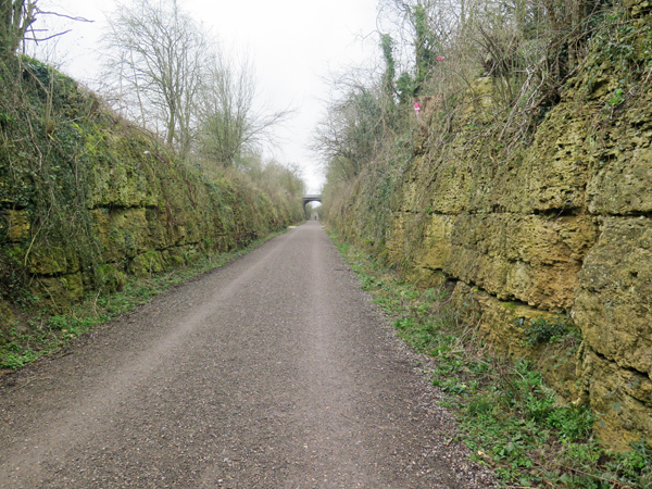
At this point, our guide Jim took us up onto the old railway that leads back to the Linear Park and Clowne town centre, where we finished our walk and thanked him for his input – especially since he had offered to accompany us on our planned field trip a few days later.
Crags on the west side of Markland Grips

Sunday 4 October 2020

Clowne Crags and the Linear Park


Clowne Crags

The reconnaissance of the section of the Clowne Branch Line Greenway, from Clowne town centre to the coal seam and back, took 1¾ hours and, with plenty of discussion having taken place amongst our group of six, the timing fitted in well with my idea for the Sheffield U3A Geology Group to stop in Clowne for lunch.

The Greenway in Clowne town centre

It might not be the most scenic place for the group to take lunch, on the old railway platform, but there is the option to grab a sandwich and a drink in the town centre; however, with our small group breaking up there, Paul and I decided to carry on with the second leg of the walk – to explore the Linear Park and Markland Grips.

An extract from the geological memoir

From this point onward, Paul May and I were in the hands of Jim Russell, who leads various walks around the area and or first stop was to see Clowne Crags, a relatively small outcrop of partially slipped limestone blocks at the head of a shallow valley that is occupied by a brook that runs eastward to Holinhill Grips.

Clowne Crags

The blocks are similar to those that I had seen at Anston Stones Wood, which have slid down a much deeper and steep sided valley by the process of cambering during the Quaternary Period. The distinct ‘honeycomb’ texture, as described in the geological memoir, is also seen at Anston Stones Wood and at Roche Abbey, and I have always assumed that these are formed by dissolution of the limestone.

A slumped block at Clowne Crags

Continuing along the Linear Park along the old Midland Railway cutting towards Creswell, further examples of the Cadeby Formation can be seen, which are generally thin bedded like those seen along Greenway West.

A channel of sand

We only stopped in a few places to take a good look at a large channel of sand that cuts through the thinly bedded limestone, a very large ivy stem and an orange organic growth on the limestone, which none of us had seen before.

Views along the Linear Park

At one place, I noticed that the limestone appeared to be wedge bedded, which is typical of the upper part of the Cadeby Formation - the Sprotbrough Member – but this was the only time that I saw this along the Linear Park.

Wedge bedded limestone

Greenway West - Part 2


A coal seam

Continuing along Greenway West, the characteristics of the limestone remain essentially unchanged, with thinner beds predominating, but with occasional massive beds that are weathered to a ‘honeycomb’ texture.

A general view

Apart from the rippled surfaces on some of beds of thin limestone, there are no obvious sedimentary structures, but vertical joints appear regularly along the section, which are frequently exploited by tree roots. I can't recall seeing any faults, although there is one place near the escarpment that is downwarped slightly.

A joint filled by a root

In a few places where thin beds of marl appear in the limestone, small springs form with boggy areas at the base of the cutting, around which sphagnum moss and various other water loving plants are flourishing. 

A spring with bog loving plants

One very interesting feature of the Cadeby Formation here, is the complete absence of bryozoan reefs, which I have seen at several places further to the north in South Yorkshire, such as Maltby Crags, North Cliff Quarry and Anston Stones Wood.

A downwarped section of limestone

Before we knew it, the old railway line had passed from solid rock to a railway embankment and, partially hidden by undergrowth and trees, there was an old quarry on the north of the track, where a large block of sandstone from the Yellow Sands Formation outcrops at its entrance.

An outcrop of the Yellow Sands Formation

A thickness of nearly 7 metres was recorded here, in the geological memoir, with the top metre being described as well cemented and quite hard. The large sample that I collected, although quite friable, remained intact in my rucksack for the rest of our walk.

A specimen of the Yellow Sands Formation

At this point, we could have easily stopped and turned back to Clowne; however, although appearing as a small isolated outcrop a few hundred metres further to the west, I had been informed by Chris Darmon that it was well worth making the effort to go look at a coal seam.

The limestone escarpment

The trees alongside the old railway largely obscure the surrounding landscape but, taking advantage of an occasional viewpoint, I was interested to see that a quick walk had taken us some distance from the escarpment.

The coal seam

Finally arriving at the coal seam, which is one of a handful that I can recall seeing – despite having lived in the middle of a coal mining district for 25 years and surveyed very many geological sites in South Yorkshire. We all thought that the site could benefit from sensitive clearance of vegetation and an interpretation board, given its rarity value.

Inspecting the coal seam