Wednesday 31 August 2022

St. Leonard's Church Scarcliffe - Part 2

 
A detail of the west window to the tower

My investigation of the exterior of St. Leonard’s church in Scarcliffe, during the Heritage Open Days festival, had revealed some interesting archaeological features relating to the construction history of the chancel and I next stopped to have a good look at the tower. 
 
The tower
 
Originally built in the C13, the tower was completely rebuilt in 1842 with buff to slightly pink coloured dolomitic limestone ashlar from the Permian Cadeby Formation, but a pink/red sandy limestone has been used for the dressings and for occasional blocks in the walling. 
 
The north door of the vestry

I had already encountered very poor quality pink/red sandy dolomitic limestone in various vernacular buildings in Palterton and Scarcliffe, which I assumed had been quarried locally from an unknown source, but my first thought was that this is Red Mansfield stone – a very sandy variety of the Cadeby Formation that, together with White Mansfield stone, developed a good reputation as a building stone and was once used widely throughout England but is now unavailable.
 
Weathered Red Mansfield stone in a buttress to the vestry
 
Looking at the vestry at the west end of the north aisle, which was built at the same time as the tower, clay partings in the stone used for the buttresses to the north-west corner have been differentially weathered to produce a very distinctive texture. 
 
Lancet windows in the west vestry wall

Moving round to the west elevation of the vestry, the window surrounds to the double lancet window are quite eroded and the window heads and mullions have been restored quite recently with cream coloured dolomitic limestone from the Cadeby Formation – a stone that is now only quarried in very few places in England and has limited colour variation.
 
The west window of the tower
 
The west window on the second stage of the tower has also had its very simple tracery and mullion restored, with what looks like two different kinds of stone. The original window jambs are made of a similar red dolomitic limestone to that seen elsewhere in the tower, but the differential weathering is of an extent that I had never seen before. 
 
A weathered jamb in the west window
 
I finished my brief examination of the tower at the west door, where the dressings look similar, at a distance, to the buff coloured limestone used for the bulk of the ashlar walling but, looking closely at weathered surfaces, some of these have a slight pinkish tinge. 
 
The west door of the tower

The dressings are all in quite good condition, compared to those that have used red sandy limestone, but the incongruous distinctly yellow blocks forming the lower part of the left jamb are weathered to a greater degree. 
 
Yellow limestone used in the west door to the tower
 

Friday 26 August 2022

St. Leonard's Church Scarcliffe - Part 1

 
The C12 priest's door in the south wall of the chancel

Having had a good look at the rock outcrops and the various building stones in the vernacular architecture of Palterton and Scarcliffe, I then proceeded to St. Leonard’s church, which was being opened to the general public as part of the Heritage Open Days festival. 
 
A general view of the south elevation of St. Leonard's church

The Grade II* Listed church was founded c.1150 by Ralph de Aincourt, along with daughter chapels in Palterton and at Scarcliffe Lanes, but was extended c.1250 with the building of the west tower, enlargement of the chancel and addition of the north aisle. Further alterations were made in the late C16 and the tower was rebuilt in 1842, with restoration work being undertaken later in the C19.
 
Rubble masonry surrounding the priest's door in the chancel

I was immediately attracted to the Norman priest’s door and the surrounding lower level stonework in the chancel, which consists of irregular rubble masonry that has extreme variation in the shape, size and colour of the individual building stones and contrasts with the surrounding walling. 
 
The priest's door

Pevsner asserts that the obviously Norman style detailing is renewed but the crude headstops look original and, according to the church guide, Dr. John Charles Cox in his Notes on the Churches of Derbyshire (1875) states that the chevron pattern had only recently been revealed, after lime plaster was removed during recent work to the church. 
 
The south elevation of the chancel

Looking at the window surrounds, the colour of the stone to the dressings of the Early English lancet window are very similar to those of the Norman rubble masonry, but the dressings of the large late Perpendicular Gothic windows either side of it have weathered to a greyish colour, which is more typical of limestone from the Cadeby Formation. 
 
The Early English lancet window

I didn’t have time to study the masonry in any detail but, from my photographs, I can see that there are changes in the regularity in the heights of courses and the degree of squaring, which provide evidence of phases of alteration and the raising of the chancel over the years. 
 
The north elevation of the chancel
 
Moving anti-clockwise round the east end of the church, the north wall of the chancel also has several points of archaeological interest. The irregular rubble walling forming the oldest masonry, which has a limewashed/plastered upper section, clearly stands out against the surrounding roughly coursed and squared stonework. 
 
The north elevation of the chancel

To the east, the chancel was extended in the C13 and a close examination reveals an infilled tall lancet window, with its dressings still being visible. Above the limewashed walling, three courses of ashlar blocks rise to the level of the hopper heads and extend to the east end, with a further four thinner courses of squared and rock faced stone forming the parapet. 
A detail of the north elevation of the chancel
 
A small Early English lancet window provides further evidence of alteration of the Norman chancel in the C13 and a Decorated Gothic (1250-1350) window, which interrupts the original stringcourse, has been added at a later date. Also, a downpipe partially obscures a blocked square headed door, which again cuts through the stringcourse but is of uncertain date. 
 
A blocked door in the north wall of the chancel

Continuing along to the lean-to north aisle, the pattern of the roughly squared and coursed rubble masonry seen in its east end doesn’t look different to that of the adjoining nave; however, a closer look reveals that the masonry of the aisle has been simply butted onto the existing masonry of the nave, where the quoins at its east end can clearly be seen. 
 
The east wall of the north aisle

Quite an unusual feature, which I have not seen before and is presumably the result of the raising of the adjoining churchyard by the large number of burials, is a trench that has been cut along the length of the north elevation to improve the drainage. 
 
A drainage trench on the north elevation
 
This prevented me from having a very close look at the masonry along the north aisle, which has three very simple square headed windows. None of these have any tracery, but the large central window has two lights separated by a mullion – suggesting that they are part of the late C16 alterations very briefly referred to in the Historic England listing description. 
 
A view of the north aisle
 

Building Stones in Scarcliffe

 
Colour variations in the limestone in a cottage on Station Road

Walking along Main Street from Palterton to St. Leonard’s church in Scarcliffe, I encountered several exposures of Permian dolomitic limestone from the upper Wetherby Member of the Cadeby Formation, which is typically cream coloured. 
 
Palterton and Scarcliffe

Having a particular interest in building stones, at the junction with the Rotherham to Mansfield road, I stopped to photograph the Horse and Groom public house and a house with converted agricultural buildings attached, both of which are shown on the 1884 Ordnance Survey map as being isolated from the rest of the village. 
 
The Horse and Groom public house

Looking at a distance, the masonry of the Horse and Groom appeared very similar to the cream coloured limestone that I encountered in the majority of historic buildings in Palterton, although I could see some isolated pink and yellow tinged blocks. 
 
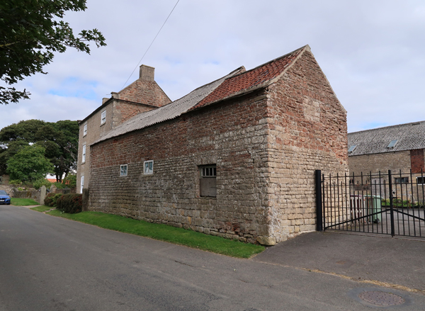
Former agricultural buildings on Main Street
 
The lower section of the group of agricultural buildings, however, are built in limestone that is distinctly yellow, which is best seen on the Main Street elevation. Although a yellow variation is very often seen when the Cadeby Formation is underlain by the Yellow Sands Formation, this is not found in the area. 
 
A terrace of late C19 houses on Main Street

Crossing Mansfield Road, I continued down Main Street for a couple of hundred metres until I reached a terrace of six late C19 houses, which have been built opposite Budget Lane. In passing, I could see that both the walling of the houses and the boundary walls are built out of cream coloured limestone, with no colour variation being obvious. 
 
Manor Farmhouse
 
A little further down Main Street, the early C19 Manor Farmhouse provides a further example of yellow and pink limestone blocks sporadically appearing amongst cream coloured limestone. This colour variation is most obvious where the greyish patina has weathered away and a similar pattern is also seen in the various farm buildings associated with it. 
 
An agricultural building at Manor Farm

Interestingly, both this and the nearby early C19 Hall Farmhouse are described in their Historic England listing entries as being built in coursed square sandstone, with sandstone dressings, which shows how variations in the Cadeby Formation can be misidentified by an untrained eye. 
 
Hall Farmhouse

Although I didn’t closely examine any of the masonry in the buildings that I saw, however, the British Geological Survey memoir for the district describes the limestone at the former Scarcliffe Station, 700 metres south-southeast, as being pink over a considerable thickness and red and sandy in places and stone of this description appears in the boundary wall to Hall Farm. 
 
Red sandy limestone in the boundary wall of Hall Farm

On the opposite side of the road to the red limestone wall at Hall Farm, what I presume to be the oldest part of the cottage is built with very large blocks of a very yellow sandstone, with much of the thinner bedded masonry surrounding it also being yellow. 
 
Large blocks of yellow limestone

Carrying on past St. Leonard’s church, which had not yet opened for its Heritage Open Days, I went to have a quick look at the cluster of historic buildings along Station Road, which appear on the 1884 Ordnance Survey map before the railway was built. 
 
A house on Station Road
 
Whereas the yellow and pink limestone had constituted only a minor proportion of the various buildings that I had so far seen in Scarcliffe, here it is now a major component of the masonry and in places is as common as the typical cream coloured limestone. 
 
Vernacular architecture with variations in the colour of the limestone
 
Except for the church, all the historic buildings in Scarcliffe are simple houses and agricultural buildings and it is therefore very probable that a local quarry supplied the stone. Two small quarries are recorded less than a kilometre to the south of the village on the 1884 map; however, without documentary evidence, the provenance of the various stones will probably  never be known.
 
Yellow limestone in an outhouse

Thursday 25 August 2022

The Cadeby Formation in Scarcliffe

 
A detail of the Sprotbrough Member to the west of Scarcliffe

Once I had left Palterton and reached the highest point of the Magnesian Limestone plateau, which has an elevation of about 180 metres, I crossed the Mansfield Road and, discovering that the stretch of Main Street leading to Scarcliffe does not have any footpaths, I proceeded along this hedge lined lane with great caution. 
 
Approaching Scarcliffe, sporadic exposures of a soft sandy rock appeared in the verges, with its reddish brown weathering products being washed down and deposited on the roadside. It was not safe to stop and investigate, but I am assuming that the lowest calcareous mudstones of the Cadeby Formation are exposed here. 

An exposure of calcareous mudstone

This exposure continued for several metres, but it was soon succeeded by an exposure of thinly bedded cream coloured dolomitic limestone. In South Yorkshire, the lower part of the Cadeby Formation - the Wetherby Member - is generally massive, with oolitic and shelly beds and it often contains bryozoan reefs but, further south in north--east Derbyshire, the reefs disappear and the beds become progressively thinner. 
 
Thin flat bedded limestone
 
There is a distinct rise in the land just before entering the village, which coincides with quite a long exposure of the same coloured dolomitic limestone in the road cutting. Examining the sedimentary structures, in addition to flat bedding, there is shallow trough cross-bedding, which is similar to that seen in the eastern end of the Clowne Greenway. 
 
 An exposure of the Sprotbrough Member with trough cross-bedding
 
The British Geological Survey memoir for the Chesterfield district states that the bulk of the Cadeby Formation and almost the whole of the outcrop of limestone in the region is formed by the upper division, the Sprotbrough Member. 
 
Easterly dipping beds exposed in a road cutting

Arriving at the Rotherham/Mansfield Road, I checked out the various locations of the bus stops for my return journey and then continued down Main Street, where there is noticeable slope down towards St. Leonard’s church, which is set at the east end of the village. 
 
Massive limestone in the Sprotbrough Member

The road here again does not have footpaths and, continuing down the hill, I encountered another small exposure of massive limestone of the Sprotbrough Member poking out of the grass verge, but the pattern of bedding could not be clearly seen. 
 
Gently dipping thinly bedded limestone

Further along, a more extensive outcrop of thinly bedded limestone can be seen, with the beds dipping gently to the east. At the corner of Main Street in Palterton, the dip is measured at 6 degrees and at the beginning of the Bolsover Tunnel, it is measured at 2 degrees and over the 2 km distance between these points, the elevation drops from 179 metres to 146 metres. 
 
A boundary wall built on thinly bedded limestone

Nowhere does the limestone form sections greater than 1 metre in height, with it often only occurring as a few thin beds that form the foundations of a boundary wall; however, despite yellow/pink/orange varieties of limestone being seen in various buildings and walls, there is no sign of pink/red colouration and the sample that I obtained is yellow in colour and granular. 
 
A sample of granular limestone (21mm diameter coin)
 

Wednesday 24 August 2022

Building Stones in Palterton

 
A boundary wall at the south end of Main Street

My main reason for visiting Palterton was to have a good look at the exposure of reddened dolomitic limestone of the Cadeby Formation at the south end of Main Street, before walking to Scarcliffe for the Heritage Open Day at St. Leonard’s church.
 
Palterton Hall

As had become usual for my walks, I had also looked at the British Listed Buildings website to see if there were any buildings in need of a photograph and, after alighting from the bus on Back Lane, I had a quick look at some converted farm buildings at Castle View – built in cream coloured limestone with a red pantile roof - before cutting through a modern housing estate to Main Street, where I soon found the Grade II Listed early C18 Palterton Hall. 
 
Lilac Farmhouse
 
It is built with yellowish dolomitic limestone from the Permian Cadeby Formation but, unlike the uniformly weathered massive limestone used for the late C18 Lilac Farmhouse, 50 metres further down the road, the walling stone contains softer beds that are differentially weathered. 
 
A outbuilding to Lilac Farmhouse

The south elevation of Lilac Farmhouse, as well as the upper section of the agricultural building attached to it, the upper part, is built in a well bedded red limestone similar to that I had previously seen in the outcrop further down Main Street. 
 
A detail of the red limestone

Zooming in to a section of the wall where the stones are not bonded, I could see that the limestone has proved not be particularly durable, with the weathered surface of the very exposed stone being exfoliated in very many places. 
 
A large barn

There is a large barn in the farmyard to the rear of Lilac Farmhouse, which is built entirely in cream/yellow limestone, but continuing along Main Street, the red limestone forms a considerable proportion of the masonry in the west wall of the neighbouring cottage. 
 
The west end of a cottage

Continuing along Main Street, various boundary walls are built in limestone typically seen in the Cadeby Formation, as is the former Mission Chapel and School House on the opposite side of the road, which was built c.1875 and has a simple grey granite war memorial in the plot next to it. 
 
The old Mission Chapel and School House

Opposite the chapel, the drive between two modern houses cuts through the well bedded red limestone, where the exposed rock forms the core of a roughly built boundary wall. It is a man made cutting, which improves access to the long strips of enclosed land and farm buildings between Main Street and Back Lane. 
 
A cutting in the Cadeby Formation
 
On Main Street, the modern garden wall obscures any rock that may have been visible, but it then reappears as a small vertical section that continues for several metres, before being interrupted by another cutting. This forms the north side of a roughly square piece of land, which has been described in Richards Bygone Times as “rock corner” and is the site of an ancient chapel dating back to the time of King Henry I. 
 
The site of the ancient chapel in Palterton

When I first visited Palterton very briefly, back in 1993, when undertaking stone identification and matching for English Heritage at Bolsover Castle, I just slowly passed by in the car and didn’t stop to take any photographs; however, I do recall that the rock face on Main Street was largely bare and I have always assumed that it is a natural feature. 
 
An ivy covered rock exposure on Main Street

Ivy now covers most of the rock exposure but, seeing glimpses of red limestone that looks so similar to that found in the buildings described above, as well as noting the various cuttings for tracks and the right angle turn on Main Street, it did make me wonder if there had been some planned landscaping of Main Street or very small scale quarrying in the past and that this stone has been used in local buildings. 
 
An outcrop of red limestone in the Cadeby Formation

Looking at the 1883 Ordnance Survey map, the nearest quarry that I could see was located a few hundred metres to the south-east at the junction of Losk Lane and Ling Lane. I don’t know this quarry, but Google Street View clearly shows that the road cutting here exposes a thinly bedded cream/yellow coloured limestone, which does not look particularly suitable for building. 
 
A Google Street View on Losk Lane

It is not unusual for stone for the better quality houses to have been brought from quarries up to 5 km away, which means that the quarries around Bolsover could be easily reached, but I have never seen any of them or know if any are still accessible. 
 
Vernacular architecture on uphill Main Street

Having achieved my objective of having another look at the Cadeby Formation and photographing the historic buildings on Main Street, I set off up towards Back Lane and immediately encountered another group of houses that are not listed, but are good examples of the local vernacular architecture. Unsurprisingly, cream/yellow limestone is mostly used, but I could also see the mysterious red limestone in the oldest part of one of them. 
 
Red limestone in the lower part of an unlisted house