Sunday 23 August 2020

A Stone Matching Exercise - Part 1


The field trip to Wharncliffe Crags and Wortley Top Forge with the Sheffield U3A Geology Group, on 16th October 2019, proved to be the conclusion of 8 months of extensive travel around South Yorkshire and the surrounding counties, during which I had visited 50 places.


A map of South Yorkshire and the surrounding counties

Before I had time to think about what to do next, I was contacted by my brother at Triton Building Restoration Ltd. with an enquiry about a stone used in the Grade II Listed Aldershot Town HallAs the contract wasn’t secured, I didn’t hold out hopes for getting paid work but, as a matter of professional curiosity, I was happy to undertake some desk top research.


Aldershot Town Hall

Looking at the BGS online Geology of Britain viewer, Aldershot is set on the unconsolidated sands of the Tertiary Bagshot Formation, a few kilometres to the north of the Chalk escarpment at the west end of the North Downs.

The Cretaceous rocks of the Wealden District are generally quite soft and suitable for local vernacular architecture, with only Kentish Ragstone from Maidstone and Reigate Stone developing a reputation as a building stone for places like the Tower of London, Rochester Castle and Westminster Abbey.


The front entrance to Aldershot Town Hall

Google Street View shows that the plinth is a dark grey, uniform cross-bedded sandstone, without obvious iron banding but with a light brown patina, which indicates the presence of iron bearing minerals. At low level, where in contact with rising groundwater, the ashlar masonry is delaminating and the arisses are rounded.


The plinth at Aldershot Town Hall

It certainly doesn’t look like any of the Carboniferous sandstones that I have encountered, or was included in my own substantial collection of building stones or the Triton Stone Library but I had to wait until I received a sample of stone through the post before I could say any more.


The Triton Stone Library

Sunday 16 August 2020

Wortley Top Forge


A general view inside the main forge

My day out with the Sheffield U3A Geology Group to explore Wharncliffe Crags finished with a guided tour of Wortley Top Forge, the only surviving water-powered heavy wrought iron forge with its water wheels and hammers in situ.

A general view of Wortley Top Forge

Dating back to 1640, with various additions over the years, it is a site of national importance and is protected as a Scheduled Monument and the main forge is a Grade I Listed building. There buildings themselves aren't of great architectural merit, but they provide a good example of the vernacular use of local sandstone - probably Greenmoor Rock from one of the quarries nearby.

An introduction to wrought iron

As soon as we arrived, we all found a place to eat out packed lunches and after an introduction to the processes and materials involved in the production of wrought iron, we proceeded on an hour and half tour provided by a very entertaining tour guide.

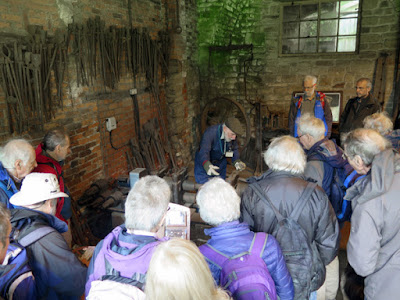
A demonstration in the main forge

We were first shown the workings of the main forge and then taken to former workshops, which are now full of a wide variety of fully operative machines that have been donated from all over the world and are maintained by volunteers.

A general view in the main forge

I was too preoccupied trying to take a set of reasonable photographs in often dim lighting conditions to hear everything that our guide was saying, but I saw enough to get a reasonable understanding of the operation of the forge.

A general view in the main forge

Like other parts of Sheffield, the Upper Don Valley had access to ironstone, coppiced timber for charcoal and water for power and iron has been worked in the valley on a small scale since the 1300’s - long before the Industrial Revolution.

Various workshops

When our formal tour had ended, everyone seemed in a hurry to get in the their cars and get back home and I didn’t have time to have a good wander around the site. The forge forms the centre of an Industrial Museum, with a large collection of steam engines and large items of plant that have been salvaged from now demolished works.

Miscellaneous plant and machinery

Friday 14 August 2020

Wharncliffe Crags


A view across the Don Valley from Wharncliffe Crags

My day out to Chatsworth House, in October 2019, concluded 8 months of extensive travel by bus and train from Treeton to more than 40 places in the counties that surround South Yorkshire - very many of which involved 2 changes in transport each way.

At the Lowood Club

This memorable year of exploration ended with a geology field trip with the U3A to Wharncliffe Crags, followed by a visit to Wortley Top Forge in the afternoon - places that I had passed by many times since living in South Yorkshire but had never visited.

A map of Deepcar and Wharncliffe Crags

Gathering at the Lowood Club on Station Road in Deepcar for our usual 10:30 start, we began with an introduction by our leader of the day, Dr. Gareth Martin of the West Yorkshire Geology Trust, and a short talk about the mining of ganister in the area.

A bat sleeping beneath a railway bridge

We then made our way up the lower slopes by a track that passed under two railway lines, one of which housed a bat, and carried on until we reached Wharncliffe Crags, a prominent rocky outcrop of the Wharncliff Rock - a medium grained massive sandstone in the Lower Pennine Coal Measures Formation.

Wharncliffe Crags

The rocks at the north-western end of Wharncliffe Crags have been quarried to produce quern-stones as long ago as the Iron Age, continuing into the period of the Roman occupation of Britain, and it is protected as a Scheduled Monument.

Blocks of Wharncliff Rock

Along the crags, two principal sandstone beds are exposed. The lower one, around 10 m thick, has well developed cross-bedding, typical of river point-bar sediments and is interpreted as the remains of a meandering river channel. The upper bed is thinner, up to 2 m, but shows interesting soft-sediment deformation structures.

Deformation structures in the Wharncliff Rock

These sections afford one of the best preserved examples of a fluvial meander belt in the  Pennines, of considerable importance for sedimentological investigations of the Coal Measures of this region and was designated as a SSSI in 1988.

Deformation structures in the Wharncliff Rock

We stopped off at several places to examine various sedimentary structures, including examples of deformation structures and sand volcanoes, which are considered to be a good indication that earthquakes occurred in the area.

An exposure of Loxley Edge Rock in an old quarry

Having looked at these unusual structures, we then retraced our steps back to the River Don, where there is an exposure of the Loxley Edge Rock in a disused quarry. Positioned at the rear of the group and some way from our leader, I just took a few photos before we returned to our cars and headed off to Wortley Top Forge.

A detail of weathering in the Loxley Edge Rock

Sunday 9 August 2020

A Tour of Chatsworth House - XVI


The Rock Garden

As a geologist, my tour of Chatsworth House proved very productive, having seen many examples of decorative stone that were quarried from its estate, a wide variety of marbles and granites from around the Mediterranean and extensive use of local gritstone.

Entering the Rock garden from the Maze

Over the years, I have seen many large outcrops of Chatsworth Grit along the famous gritstone edges that rise up to the east of the River Derwent in the Peak District National Park and I know its physical characteristics very well. 

A general view

Walking from the Grotto down the hill towards the house, on the last leg of my exploration of Chatsworth House, I walked through the Maze and was completely taken aback by the scale of the Rock Garden. The largest construction, the Wellington Rock, is nearly 14m high and has a waterfall running down it. 

The fountain on the Wellington Rock

The Rock Garden was built as a reminder of a visit to the Alps, which formed just one part of a Grand Tour of Europe that the 6th Duke of Devonshire undertook with Joseph Paxton. These were becoming increasingly fashionable in the mid-19th century, but few were conceived on such a massive scale as this. 

A geological map of the area around Chatsworth House

The work began in 1842, with stone being brought down from Dobb Edge, north of Stand Wood and perfectly positioned around the garden using large steam-powered apparatus designed by Paxton himself. Given that the large blocks were also brought from nearly 2 km away, across rough and steeply sloping terrain, this is quite a feat. 

A rock stack made of shaped blocks

Sometimes, the stacks are built in roughly squared blocks of rock, with beds of mortar being clearly evident, but others have been carefully built to look like the original natural rock feature as closely as possible. 

Reproduced bedding planes

To this effect, ‘bedding planes’ have been cut into massive sandstone with hand tools, to reproduce the appearance of graded bedding and large scale cross-bedding, which are characteristic features of the Chatsworth Grit. 

The Strid

The garden also contains a large water feature called the Strid, based on a chasm of the same name, which is cut by the River Wharfe on the Duke’s Bolton Abbey estate in Yorkshire. Although the garden has been redesigned in recent years, the surrounding rocks were planted with wild currants, bilberries and other plants brought from Bolton Abbey. 

The Rock Garden

It was now 16:30 and I had less than a half hour left before I caught my bus back to Sheffield. I could easily have stopped to have another coffee but, with spells of sunshine to take advantage of, I had a quick walk around the Canal Pond to take photos of the south elevation of the house.

The south elevation of Chatsworth House

Friday 7 August 2020

A Tour of Chatsworth House - XV


The Grotto

From the Trout Stream, I continued with the exploration of the gardens of Chatsworth House by heading south along the main path, which runs parallel to the escarpment of Chatsworth Grit that rises above it. 

The Grotto

The Grotto is essentially a very large rock arch made of rough rectangular blocks of gritstone, with a cylindrical summer house with a conical roof rising up behind it, and was originally built by White Watson for the Duchess Georgiana in 1798. 

The Grotto

A first impression is that it is of very crude dry stone construction, given the very irregular nature of the flanks to the structure but, when viewing the entrance to the Grotto from the west, it can be seen that the arch and its surrounds are made with alternate rough blocks of gritstone and large sections of flowstone and tufa that have been shaped to fit tightly together. 

Flowstone and tufa alternating with gritstone

I have seen tufa used locally in vernacular architecture in Matlock Bath and Alport, but I had never seen flowstone used as a building stone. The Grotto was much altered by the 6th Duke in the 1820s and its use might reflect his love of stone in many forms, with Poole’s Cavern being a possible source. 

Flowstone and tufa alternating with tufa

Just beyond the Grotto, several large blocks of Chatsworth Grit litter the lower slopes, which are one of the constituents of a loose geologically recent sedimentary deposit known as head, which usually forms beneath the gritstone edges.

Boulders of Chatsworth Grit

Although I have never seen crags at Chatsworth like in other places further north along the Derwent Valley, like Curbar Edge, these large blocks will have detached themselves from the escarpment by the process of cambering and then slipped with other rock debris down the slope.

A general view of the Grotto and Chatsworth Grit boulders

Wednesday 5 August 2020

A Tour of Chatsworth House - XIV


The Cascade House

William Cavendish, the 1st Duke of Devonshire, was one of the first Englishmen to embrace the creation of formal gardens already fashionable in France, Italy, and Holland and, having briefly explored the greenhouses and Rose Garden at Chatsworth House, I set off towards the Cascade.

A view down the Cascade

These were originally completed in 1696 to a design by Monsieur Grillet, a French hydraulics engineer who was a pupil of André Le Nôtre - the landscape architect responsible for the gardens at the Palace of Versailles

The Cascade House

The cascade was then remodelled, with the Cascade House built in 1702 by Thomas Archer and largely completed by 1708. Work continued on the Cascade Pond, which lies a little higher up the hill, until 1712 and Joseph Paxton later made modifications when he drove a tunnel beneath it.

A dolphin and frostwork rustication

With plenty more of the gardens still to see, I didn’t explore the lower parts of the Cascade and only took a few photographs of the views and the Cascade House, where there are carvings by Samuel Watson and Henri Nadauld - a descent of a Huguenot family that settled in Ashford-in-the-Water. These include dolphins, reclining figures and frostwork rustication, a finish in the form of stalactites that I had never seen before. 

A view west towards Edensor

I made my way back to the path and then carried on to the Trout Stream, designed by Paxton in 1835 when he started work on the new Arboretum. It was a huge task involving the diversion of a local stream more than two miles from its natural course on East Moor. 

The Trout Stream

The garden also incorporated elements of Paxton's rockery, including a rock wall and rock stacks made from gritstone transported from Chatsworth. A series of new semi-wild planting schemes along its entire length, designed by Dan Pearson, have been installed since 2016. 

Rock stacks at the Trout Stream

As with the rest of the gardens at Chatsworth House, various modern sculptures are scattered around the Trout Stream and, like at the Yorkshire Sculpture Park, they are a great addition to the surrounding landscape.

Modern sculpture around the Trout Stream