Saturday 24 October 2015

Anston Stones Wood


The "Little Stones" at Anston Stones Wood

Having previously described several places in West Yorkshire, where I assessed their value for some new field trip locations for Geotourists, I now return to the part of England that I know best.

Differential weathering in the south cliff
As the principal surveyor for the South Yorkshire RIGS Group, and consultant geologist to the Peak District National Park Authority and Natural England,  I have visited a few hundred sites in and around South Yorkshire.

Anston Stones Wood is just one of a handful of RIGS that were selected as “showcase sites” and is set in one of several gorges that have been cut through the escarpment of Magnesian Limestone in this part of England.


The Geological Trail
Here, the Permian dolostone of the Cadeby Formation has been cut through by glacial meltwater flowing from the Pennines to the west – during the Quaternary Period - leaving cliffs and a valley that is now full of slumped blocks of rock and loose material, through which Anston Brook meanders. The limestone is further exposed in railway cuttings, which accommodate the freight line that still passes along the gorge.

Along its length, there are exposures of massive, horizontally bedded dolostone, with small caves and examples of flowstone and, although heavily overgrown and sometimes not easily accessible, there are also bryozoan reefs. Occasionally, outcrops of the underlying Mexborough Rock can be seen in the banks of Anston Brook.

The Anston Stones Wood Geological Trail, which flew off the shelves wherever it was stocked, highlights some of the points of interest that can be seen from the numerous public paths that traverse this biological Site of Special Scientific Interest and, if great care is taken not to disturb the flora and fauna, there is still a lot more to be seen.

The Cut

I have accompanied various local natural history groups to look at the geology, botany and other wildlife – there are green woodpeckers, but I have not seen the kingfishers yet - and very many other societies visit this very special place for their field trips. 
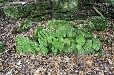
Weathering of a fallen block of stone in The Cut

Once you have had a good long walk around Anston Stones Wood, there is another story to be told in Anston - the quarrying of the stone used to build the Palace of Westminster.

The Palace of Westminster

Thursday 22 October 2015

The Roundhay Park Fault


A view across the Roundhay Park Fault to the Rough Rock

Arriving in Leeds from the south, the gentle dip and scarp topography formed by the Coal Measures strata fades away into the Aire Valley, with much of the city being quite low lying; however, the topography changes quite dramatically to the north, with a thick slab of the Elland Flags rising above the city to form higher ground around Oakwood and Roundhay.

Roundhay Park Gorge

Wandering around Roundhay Park to take in the landscape, the original water courses have obviously been obscured by the artificial lakes; however, the topography records the erosion of the Elland Flags – and the Rough Rock – along with their associated softer siltstone and shale, to form various gentle escarpments and vales.

A view across the Roundhay Park Fault to the Elland Flags

The meandering brook, now gently flowing through Roundhay Park Gorge, doesn't have the erosional power to have created the steep sided valley that now exists and this provides evidence that fast flowing glacial meltwater - in Quaternary times - once cut through the hard rock.

A Geological Map of the British Islands

Looking at a Geological Map of the British Islands that hangs on my office wall – the 1969 edition, at the scale of 25 miles to the inch – there is a very distinct break between the Coal Measures and the Millstone Grit, which I have often wondered about.

Folded Carboniferous siltstone and shale

In South Yorkshire, and the parts of West Yorkshire that I had previously visited, the Coal Measures strata generally dip in a north-easterly direction – at Roundhay Park, the sharp change in the landscape to the north of Victoria Park can be partially explained by the appearance of the Roundhay Park Fault.

The geology around Roundhay Park

The Castle at Roundhay Park provides yet another unexpected insight into the variety of geology that can be found around this part of West Yorkshire - to the east, there is a deposit of Quaternary glacial till, which is the source of cobbles of Carboniferous sandstone used in its construction.

The Castle at Roundhay Park

Monday 19 October 2015

A Walk in Roundhay Park


Roundhay Park Gorge

When exploring the geology, ancient monuments and architecture of West Yorkshire by public transport, my travel pass limits me to stops on the railway lines that run directly from South Yorkshire and, although ongoing travel by bus is unrestricted, this sets a practical limit to the places that I can realistically visit in a day.

The geology around South Yorkshire

Having been able to get from Treeton to Kirkstall Abbey and back, in December, my last trip to West Yorkshire was undertaken 6 months later on a sunny day in May, when I took a good long walk around Roundhay Park.

The Mansion at Roundhay Park


Roundhay Park is one of the largest city parks in Europe, with its history going back to the time of the Norman Conquest of England. The land was originally granted to Ilbert de Lacy, for his part in the “Harrying of the North” and has changed hands many times since.

The Barrans Fountain

Now, a fine country house overlooks an estate that has been quarried for stone, mined for coal and subsequently reworked by landscape architects on a grand scale - with lakes and formal gardens. 

The geology display at the Visitor Centre

At the visitor centre, an interactive display provides a brief introduction to the geology of the area - and guided tours of Roundhay Park Gorge are available - but there is much more to be discovered when you take a good look around.

Saturday 17 October 2015

Building Stone in Leeds & Huddersfield


Leeds Town Hall

When visiting Kirkstall Abbey and Beaumont Park, to see the Rough Rock, I spent some time wandering around the centres of Leeds and Huddersfield - to visit the museums and art galleries and to look at some of the stone built architecture.

Leeds City Museum and the Corn Exchange

Like Sheffield, Leeds expanded rapidly during the industrial revolution and is largely brick built; however, there are several fine public buildings constructed in local Carboniferous sandstone – from the Millstone Grit and the Elland Flags - including the Town Hall, Leeds City Museum and the Corn Exchange. Sandstone details also adorn many of the Victorian buildings but it is Portland limestone, from the south coast of England, that is used in very many of the later developments.

The Romans - a temporary exhibition at Leeds City Museum

Huddersfield possesses a very different character and the majority of the old buildings – civic, ecclesiastical, commercial, industrial and residential – are built from the local sandstone, predominantly the Rough Rock. Whilst most of the industrial buildings – and some 20th century civic buildings - are very functional and austere, there are very many Neoclassical buildings - including Huddersfield Railway Station - with fine examples of elaborate stone carving.

Stone built architecture in Huddersfield

The old industrial cities of northern England aren’t obvious tourist attractions and, like me, you would probably only visit these places when on business but, combined with a visit to one or two of the many sites in the region - which have been identified as having geological interest – they can make a very interesting day out for the Geotourist.