Friday 31 December 2021

Rawmarsh and Swinton - Part 4

 
The monument to the Rockingham Pottery

During our exploration of the area between Rawmarsh and Swinton to date, my next door neighbour Dan and I had encountered some interesting geology and archaeology, as well as the fine sculpture in Birch Wood.
 
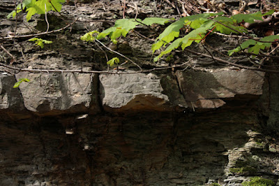
Now on the Oaks Rock, which forms a significant local landform, it is the underlying Swinton Pottery Coal and its seatearth – composed of fireclay and pot-clay – which were essential to the Swinton pottery industry, established c.1740
 
A lodge at the Rockingham Pottery
 
Arriving at the remains of the Rockingham Pottery, which had an international reputation and is now a Scheduled Monument, we only had a very brief look at the lodge and various ponds, which are considered to be former brick pits.
 
An old brick pit at the Rockingham Pottery
 
Much to my great dismay, I noted that the brickwork on the upper part of the Rockingham Kiln was full of saplings, which just reinforced my opinion that Rotherham MBC just don’t seem to care about the heritage assets that fall within the borough.
 
The Rockingham kiln

The Historic England listing, the 1855 Ordnance Survey map and the British Geological Survey memoir for the Barnsley district all refer to coal, clay and sand pits in the immediate locality; however, there is no indication where these may be and LIDAR coverage is not available here.
 
An extract from the memoir for the Barnsley district

Leaving the Rockingham Pottery, we headed up to the Woodman Roundabout to buy a drink but, before doing so, I went to have a close look at the monument to the Rockingham Pottery, made in Cadeby limestone and charred recycled oak by Lewis Morgan and Dan Jones.
 
The monument to the Rockingham Pottery

On this occasion, we didn’t investigate Three Corned Plantation - the triangle of land between Blackamoor Road and Warren Vale - which was one of the sources of clay that was found on Swinton Common, or the sites of the old coal pits in Creighton Woods.
 
An 1855 map of Swinton Common

Making our way along the path that runs parallel to the course of the stream, we then headed towards Wentworth Road and, after eventually finding the path, encountered another section of the Roman Rig in Chain Bar Plantation, where we also found many lumps of crozzle.

A section of the Roman Rig in Chain Bar Plantation

Rawmarsh and Swinton - Part 3

 
Hoober Stand on the escarpment of Abdy Rock

Having had an excellent start to our investigation of the area around Rawmarsh and Swinton, with the discovery of the Abdy Coal and associated strata, Dan and I set off to find the public footpath that would takes us to the first “Roman Ridge” marked on the 1:25,000 Ordnance Survey map.
 
A map of the area between Rawmarsh and Swinton
 
After a short walk on the path that runs north between a housing development and Warren Vale, we arrived at Birch Wood, where the Collier Brook, a tributary of the River Don, occupies a valley that has been cut through the Abdy Rock into the underlying softer rocks.
 
Birch Wood
 
The main intention was to find the best path that would lead us to Wentworth Road, on the north side of the valley and hopefully discover a “Roman Ridge”, but after seeing the magnificent “The Monster of Birch Wood” by Jason Turpin-Thomson – in the form of a Viking longship – I forgot all about it when walking up the other side of the valley back onto the Abdy Rock.
 
The Monster of Birch Wood

Arriving at Wentworth Road, we headed west until we reached the public footpath at Warren House Farm and followed this to the north, down the dip slope of the Abdy Rock, where I immediately noticed an old waste tip, which I later discovered was from the Warren House b Colliery – one of many collieries that once operated in the area.
 
The sites of former collieries in the area

On this part of the walk, I hadn’t expected to find any rock outcrops but, as with my recent exploration of the area around Kimberworth, the panoramic views of the landforms in front of me gave me a much better appreciation of the Oaks Rock – a sandstone that forms a considerable escarpment throughout its outcrop.
 
A panoramic view of the escarpment formed by the Oaks Rock

Continuing down the path towards Abdy, I was surprised to see a large expanse of relatively flat ploughed land. I thought that this must be underlain by the soft mudstones on the Pennine Middle Coal Measures Formation, but it is actually mapped as the Abdy Rock.
 
Agricultural land on the Abdy Rock
 
A little further down the path, a field boundary dotted with a few small trees marks the position of a section of the northern branch of the Roman Rig, which on closer inspection comprises a raised dyke only a couple of metres heigh, with a ditch on its south side.
 
The Roman Rig at Abdy

Walking along the path through Wath Golf Club, the path is packed full of lumps of a dense blueish slag like material with a glassy appearance, which is one of the waste materials from the nearby Rockingham Works that was set aside and sold for use in road repairs.
 
Waste material from the Rockingham Works

Carrying up through Wath Wood, the Roman Rig reappears, this time with a larger bank and ditch but, as with the previous section at Abdy, it doesn’t follow any topographical feature and at the top end of the wood, it has been obliterated by housing.
 
The Roman Rig in Wath Wood

Tuesday 28 December 2021

Rawmarsh and Swinton - Part 2

 
An ochreous deposit below the Abdy Coal

Having parked near to the north-east corner of Victoria Park on Old Warren Vale, we made our way through the plantation towards the northern end of the 200 metre long outcrop of the Abdy Rock, which forms a west-east running ridge through which the cutting was made. 
 
An outcrop of Abdy Rock on Warren Vale
 
Although spring was now well advanced, several outcrops of the northward dipping sandstones could be clearly be seen through the undergrowth, as occasional large projecting blocks of massive sandstone and thinner beds that are sandwiched with siltstone and mudstone – interpreted as crevasse splay deposits, when an ancient river channel overflowed its banks onto the surrounding floodplain. 
 
An exposure of sandstone and siltstone

With my Estwing hammer, I collected a sample of one the more massive sandstone beds, which has been described in the Geological Survey of Great Britain 1947 memoir as a current bedded, often fine grained sandstone that varies greatly in thickness from place to place. My sample is greyish in colour, with pronounced iron banding and also contains flattened ironstone nodules, as seen at Grange Moor Quarry. 
 
A specimen of Abdy Rock

Continuing south along Warren Vale, we encountered progressively older rocks, including black carbonaceous shale, containing what appear to be traces of finely striated fossil plant material, which then pass down into increasingly coaly beds. 
 
A specimen of coaly shale

A little further along Warren Vale, we were both quite taken aback by an exposure of quite massive sandstone, immediately beneath which is what looks like to be a highly fractured seam of bright coal – at the base of which is a flowstone like ochreous deposit, which itself passes down into a weathered grey mudstone. 
 
An exposure of coal and an underlying ochreous deposit

On the geological map, the Abdy Coal is marked as appearing immediately beneath the Abdy Rock and p. 68 of the 1947 memoir further describes the coal seam here as being very poor and split up with dirt partings. 
 
A section at the exposure of the Abdy Coal
 
With no obvious easy access to this very unusual exposure, I didn’t try to obtain a specimen on this occasion and had to settle for a few photographs taken at a distance from the roadside and the nearest vantage point, which Dan and I had scrambled up to.
 
A detail of the Abdy Coal and ochreous deposit

Rawmarsh and Swinton - Part 1

 
An outcrop of the Abdy Rock on Warren Vale

During my investigation of the geology around Ockley Bottom, Kimberworth and Bradgate in the north-west part of Rotherham, I traversed a sequence of rocks that comprises the upper part of the Pennine Lower Coal Measures Formation (PLCMF) – from the Whinmoor Coal to the Vanderbeckei Marine Band – as seen on the British Geological Survey Sheet 87 map for the Barnsley district.
 
A section through the upper part of the PLCMF

It consists of several sandstone members, including the Whinmoor Rock, the Silkstone Rock and the Parkgate Rock, which form distinct topographic features, along with intervening mudstones, bands of ironstone and coal seams - all of which were once widely exploited by the local iron and steel industry and used to build houses.
 
An exploration of 'Rotherham Roman Ridge' by Rotherham MBC

For my next day out, I again used a leaflet on the Casual Ramblers website as the basis for my further investigation of the geology of Rotherham, this time to explore the Abdy Rock - the Pennine Middle Coal Measures Formation sandstone upon which Hoober Stand, one of Rotherham’s most recognisable landmarks, has been built.
 
A geological map of the area around Rawmarsh and Swinton

The Rotherham MBC produced leaflet was one of a series that provided an introduction to a series of embankments that are marked on various Ordnance Survey maps as “Roman Road or Roman Ridge”, but which are actually considered to be the remains of Brigantian defensive earthworks known as the Roman Rig.
 
An Ordnance Survey map showing parts of the Roman Ridge

Except for surveys of potential RIGS in the area and a brief visit to the Rockingham Kiln, I hadn’t explored this area on foot, but I had noticed an excellent roadside exposure of the Abdy Rock on the former Rose Hill cutting (now Warren Vale), which the British Geological Survey 1947 memoir recorded as being an important section when it was excavated in 1931, as part of the upgrade of the road from Rawmarsh to Swinton.
 
A description of a rock section seen in the Rose Hill cutting

Passing by it many times since on the bus, I have seen it slowly disappear behind the trees and undergrowth but, with plenty of it still visible, I decided to make this the start of my walk – this time with my next door neighbour Dan, who had accompanied me around Treeton earlier in the year.
 
The west side of the Rose Hill cutting

Sunday 26 December 2021

The Coal Measures Group in Bradgate

 
A distant view of Bradgate Quarry

By the time that I finished having a quick look at Masbrough Cemetery, I had been walking for 4 hours and had covered a distance of 8 km and I could easily have decided to stop for the day, having encountered some interesting geology at Thundercliffe Grange quarries, Ockley Bottom and Grange Moor Quarry and had a good look at the building stones of Kimberworth.
 
My exploration of Kimberworth

Crossing over Kimberworth Road to the entrance of Bradgate Park, however, I caught sight of the large disused Bradgate Quarry on Wortley Road in the distance, which I had tried to gain access to back in 1996, when I was undertaking surveys of the potential RIGS (Regionally Important Geological Sites) in South Yorkshire.
 
A view across Bradgate Park to Bradgate Quarry

At that time, I was refused permission in no uncertain terms by the occupiers, who operated a car salvage, dismantlement and spares business and so I didn’t get to see this extensive exposure of the Parkgate Rock, which the 1947 memoir describes as a 'fairly massive fine grained sandstone – exposed over a section of 35 feet and possessing small faults and red staining in places'.
 
Resigning myself to the fact that I still hadn’t been able to get to see an outcrop of the Parkgate Rock, I just took a few photos of the rock face that I could see with the zoom lens on my Canon Powershot G16 camera and headed down Wortley Road.
 
An exposure of the Parkgate Rock at Bradgate Quarry

Before catching the bus back to Rotherham, I finished my exploration of the geology of the north-west part of Rotherham by having a look at Bradgate Brickworks, a geological Site of Special Scientific Interest (SSSI) that I had visited on a couple of occasions, when the South Yorkshire RIGS Group was still active.
 
The geological section at Bradgate Brickworks

Designated in 1988, it is considered to be the best available exposure of strata lying immediately above the Clay Cross Marine Band (= Vanderbeckei Marine Band, Westphalian B – Middle Carboniferous) in the Pennine coalfields. The marine band itself is poorly exposed here, but 30 or so metres of overlying non-marine sediments have been recorded – including the Lidgett Coal Seam, a useful marker horizon which occurs over a wide area.
 
I can’t remember exactly when I last visited but, although the old quarry face was fronted by an area of scrubland where there were occasional dumped cars, it was easy enough to gain access. On this occasion, I discovered that a small housing estate had been built on the southern part of the site, with boundary fences now stopping general access there.
 
The overgrown quarry face behind the Leatham Avenue housing estate

Carrying up Fenton Road to another part of the site, where I could previously see coal seams in the quarry face from the roadside, I was a bit disconcerted to find that the whole area was covered in hawthorns, which I thought may have been planted to deter visitors.
 
An impenetrable growth of hawthons at Bradgate Brickworks

Not being able to see the old quarry face any longer, I made my way up along the northern edge of the quarry to see what I could find and, after stopping to look down at a seemingly impenetrable mass of trees and bushes, I came to a place where I could just make out a coal seam that was not yet obscured by the saplings growing on the lower slopes.
 
A glimpse of a coal seam at Bradgate Brickworks

I have since learned that, in November 2001, Rotherham MBC had expressed concern that overgrown vegetation presented a risk to the geological features of the quarry face and proposed that the site be bought and managed by them, but it appears that this didn't happen.
 
A coal seam at Bradgate Brickworks

As the Chairman and the principal surveyor for the South Yorkshire RIGS Group at this time, I hadn’t been made aware of this at the time but, as I have seen at Boston Park and Maltby Crags, the conservation of Rotherham’s geological heritage doesn't rank high on their priorities.
 
Geological conservation in South Yorkshire

Saturday 25 December 2021

Historic Architecture in Kimberworth

 
A gargoyle at Masbrough Cemetery

Finally arriving at High Street in Kimberworth from Little Common Lane, having explored some of the local geology at Thundercliffe Grange, Ockley Bottom and Grange Moor Quarry, there is not much to suggest that the village - now just a suburb of Rotherham – has ancient origins.
 
The site of Kimberworth motte and bailey castle on a LIDAR map

Listed as Chiberworde in Domesday Book, Kimberworth formed part of the manor of Roger de Busli and possessed a motte and bailey castle, the remains of which are now hidden behind a housing estate, but it was not recorded as having a church.
 
Old Hall Farm

Continuing down towards Church Street, I caught a glimpse of the farm buildings at Old Hall Farm, which date back to the mid C18 and, on the opposite side of High Street and on Peter Street – where I lived for a year - there is a small group of Victorian terraced houses.
 
Terraced houses in Kimberworth

On my walk so far, I had crossed very many of the various strata that are depicted on the British Geological Survey Sheet 87 map, including the Silkstone Rock (SR) and the Parkgate Rock (PR) – which I had recently encountered when briefly surveying various Grade II Listed buildings around City Road and Norfolk Park Road in Sheffield.
 
The geology of the area around Kimberworth

As with the sandstone used for these buildings in Sheffield, without documentary evidence to back up my observations, I can again only make a guess at the provenance of the building stones used in Kimberworth – especially since it is only the very distinctive Rotherham Red sandstone that has gained any reputation as a building stone in the area.
 
The tower at St. Thomas' church

Making my way down Church Street, I only took a few photographs of St. Thomas’ church for the British Listed Buildings website but I did notice that the sandstone used in the tower is rich in iron, with the Liesegang rings being differentially weathered.
 
The Manor Barn and Kimberworth Manor House
 
A little further down Church Street, the unlisted Manor Barn public house is built in a very similar sandstone, as is the late C17 Kimberworth Manor House to the rear of it – which is the most interesting historic building in the village. Sadly, two other Grade II Listed buildings in its grounds - a dovecote and an old barn - have been sadly neglected.
 
A neglected dovecote and barn

After the latest COVID-19 Pandemic lockdown, the beer garden was full of people enjoying the mid April sunshine and, after taking advantage of the good weather to enjoy a pint of cold lager shandy myself, I continued down Kimberworth Road to Masbrough Cemetery.
 
The chapels in Masbrough Cemetery
 
I know very little about the cemetery, except that it was opened in 1868, but the pair of unlisted chapels caught my eye, not least for the orange rock-faced Carboniferous sandstone, which I hadn’t encountered before or have seen since.
 
The lodge at Masbrough Cemetery
 
Although the development of a patina and algal growth on large sections of the masonry obscures its original colour, in conjunction with Rotherham Red sandstone and another massive sandstone used for dressings and ashlar, the chapels have been designed with a polychrome effect – a pattern repeated in the lodge at the entrance to the cemetery.
 
A tower with grotesques

I would like to know who is the architect responsible for their design, because the chapels with tall ornamented towers, complete with gargoyles and winged grotesques, remind me of the American Gothic Revival style houses that often feature in old horror movies.
 
Grotesques at Masbrough Cemetery