Sunday 27 March 2022

Historic Architecture in Ravenfield

 
Vernacular architecture on Main Street

Leaving St. James’ church in Ravenfield, I continued my walk by heading along Church Lane, where I stopped to have a look at the tourist information panel that is set on a blocked doorway to the former garden of the now demolished Ravenfield Hall.
 
A blocked doorway on Church Lane

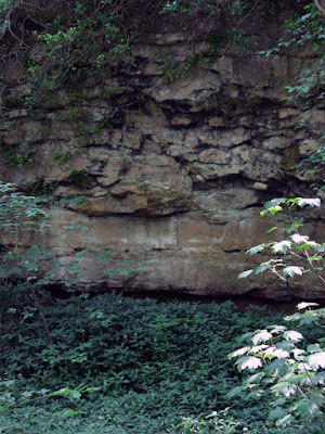
When looking for the POW inscription carved by the Italian prisoners of war who were kept at Ravenfield Park, which is barely discernable, I immediately noticed that the sandstone used to build the boundary wall had yellow and pink/red colour variations, as described in the 1947 geological memoir for the Barnsley district.
 
The weathered POW inscription
 
This reddening and mottled appearance is a common feature of the Pennine Upper Coal Measures Formation sandstones that lie immediately beneath the Permian strata and is the result of the oxidisation of iron minerals in the sandstone by percolating groundwater in an arid environment.
 
Vernacular architecture on Church Lane

Continuing along Church Lane into the village, there are several examples of vernacular architecture that are built out of a soft yellowish sandstone, which has similar pink/red mottling to a significant amount of the masonry and does not look like the stone at St. James’s church.
 
Rotherham Red sandstone used for walling at 2-6 Main Street

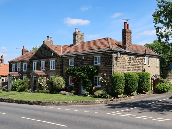
Arriving at Main Street, I was interested to see that the first three of a Grade II Listed terrace of seven cottages are built in the Rotherham Red variety of Mexborough Rock and not the local Ravenfield Rock, which has been used for all of the other buildings that I saw in the village.
 
Ravenfield Rock used for building 8-14 Main Street
 
Given that the simple cottages were occupied by workers on the Ravenfield Park estate or at the quarries to the south of the village, which mainly produced grindstones, it is surprising that an effort was made to bring stone from another source. Although I have not yet discovered potential sources, it is very probable that the quarry was the same one that supplied stone for the buildings in nearby Hooton Roberts.
 
Vernacular architecture on Main Street

I quickly walked to the end of the village to have a look at the rest of the older stone buildings, including the Grade II Listed Oak House and 3-5 Main Street, but I didn’t see anything other than coursed and squared sandstone walling in the fabric that has been used elsewhere.
 
The entrance gateway to Ravenfield Hall
 
Retracing my steps back to the centre of the village, I then headed north down Ravenfield Lane where I first came to the very impressive Grade II Listed entrance gateway to Ravenfield Hall, which is built in blocks of massive sandstone.
 
A gate pier at the entrance to Ravenfield Hall

I was curious to see the old stable block but, with the drive being private property, I could only sneak a view using the zoom lens on my Canon Powershot G7 X Mark II; however, even seen from a distance, the sandstone appears to lack the typical pale yellow colouration and pink/red mottling that is a feature of the Ravenfield Rock used for the vernacular architecture in the village.
 
The stable block to Ravenfield Hall

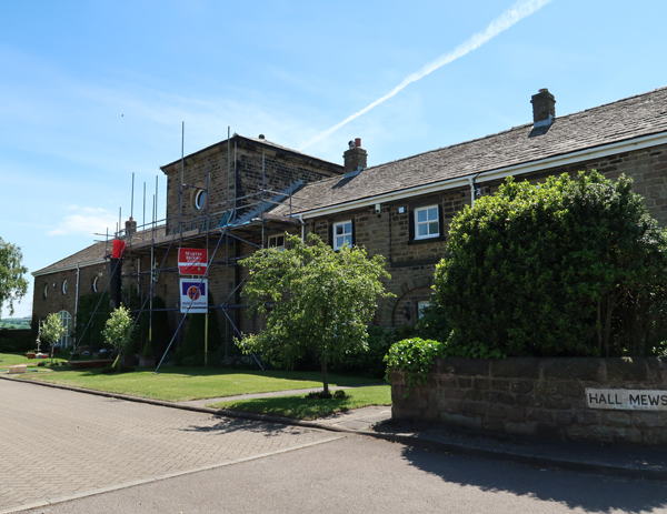
Continuing along Ravenfield Lane, I soon came to Hall Mews and photographed the Grade II Listed farm building, again from a distance, but the elevation that I could see was in shade and I cannot determine the characteristics of the sandstone used here.
 
The farm building at Hall Mews

Having finished photographing the various buildings that were part of the Ravenfield Park estate, I carried on down Ravenfield Lane and hoped to find a shortcut to Thrybergh Country Park. Although I could find no footpaths and had to walk all the way down to Doncaster Road, where there was not much to see, I did encounter a reddened medium grained sandstone in a boundary wall that I thought might be Wickersley Rock.

Reddened sandstone on Ravenfield Lane

Saturday 26 March 2022

St. James' Church in Ravenfield

 
Differential weathering of sandstone at St. James' church

Arriving in the village of Ravenfield, having examined the geology of Hooton Cliff and the area around Firsby Hall Farm, the first building that I saw was the Grade II* Listed Church of St. James, which was built in 1756 for Elizabeth Parkin – a rich Sheffield socialite - to the design of the eminent architect John Carr.
 
The south elevation of St. James' church

Except for Derby Cathedral, where the main body of the building was rebuilt in 1725, I can’t remember the last time that I had seen a Georgian church and, although I didn’t expect it to have any great archaeological interest, it has some interesting features.
 
The tower

As with most Georgian architecture, it is elegantly proportioned and without extravagant ornamentation, but the ogee arched windows with Y-tracery throughout the church and the quatrefoil panels below the belfry stage of the tower are quite unusual details.
 
A detail of a window head in the nave

On this occasion, however, I was most interested in the sandstone that has been used for the ashlar masonry, which is uniformly light brown in colour, medium grained and has marked current-bedding, with the softer beds within it being differentially weathered.
 
Differential weathering of the sandstone

Except for the Rotherham Red variety of the Mexborough Rock and, perhaps the Wickersley Rock, the Coal Measures strata in Rotherham don’t possess a reputation for producing building stone that is suitable for good quality ashlar masonry and I was very curious to know more about the provenance of this stone.
 
Weathering of sandstone above the plinth

The sandstone in the barn at Firsby Hall Farm and the limited outcrops of Ravenfield Rock, which I had seen earlier on my walk, are current-bedded and have a uniformly light brown/yellowish colour, but it is hard to imagine that the local quarries – or the stonemasons employed there – were capable of producing the high quality masonry for this church.
 
The apse at the east end

Without supporting documentary evidence I can only speculate but, with John Carr being the leading architect in northern England - based in York - it wouldn’t surprise me if a stone that was familiar to him had been shipped from West Yorkshire along the River Aire to the River Don and taken overland to Ravenfield - especially since he was also commissioned to build the now demolished Ravenfield Hall.
 
A weathered sandstone grave slab

The church wasn’t open at the time of my visit and I only spent 15 minutes having a very quick look at the exterior and the churchyard, but there are also a few gravestones that provide interesting examples of weathering and some fine letter cutting.
 
An example of letter cutting

Monday 21 March 2022

A Walk From Hooton Cliff to Ravenfield

 
The Magnesian Limestone escarpment at Clifton

After spending half an hour exploring the geology of Hooton Cliff along its length, the escarpment was brought to an abrupt end by a fault that brings the Cadeby Formation into contact with the Ravenfield Rock – the uppermost named sandstone of the Pennine Upper Coal Measures Formation (PUCMF) exposed in Rotherham.
 
The next leg of my journey involved a walk down to Firsby Lane along an extremely narrow public footpath that crossed a field of waist high barley, where I dreamily recalled the opening scene to the film Gladiator.
 
A view towards the Magnesian Limestone escarpment at Clifton

Looking across the PUCMF strata to the east, which form an undulating landscape, in the distance I could clearly see the village of Clifton, which is set on a part of the Magnesian Limestone that forms a very distinct escarpment.
 
A female pheasant

Continuing along the footpath, where the very sandy soil confirmed that the bedrock was still the Ravenfield Rock, I encountered a female pheasant who was also wandering along this path. I don’t know who was more startled, me or her, but once she had disappeared, I just followed the path until I reached Firsby Hall Farm, where I took photos of a converted barn and an ornate doorway for the British Listed Buildings website.
 
Listed buildings at Firsby Hall Farm

Just before arriving at Ravenfield Ponds, which were once the fish ponds to the now demolished Ravenfield Hall, I came across a small roadside exposure of irregular current-bedded Ravenfield Rock, a sandstone that I had not seen before.
 
A roadside exposure of Ravenfield Rock

With my Estwing hammer, I collected a small sample of sandstone from one of the exposures that displays prominent current-bedding, which is fine grained and yellowish in colour; however, the 1947 geological memoir for Barnsley mentions that the Ravenfield Rock often has red staining.
 
A specimen of Ravenfield Rock

Just beyond the roadside exposure, I then encountered an old quarry where the faces were overgrown and obscured by trees and thick undergrowth, but this is described in the memoir as showing 20 feet of thick, irregular, current-bedded sandstone and in one place a small section of this can still be seen.
 
An exposure of ravenfield rock in an old quarry

After Firsby Brook leaves Firsby Reservoir, which was constructed by the Doncaster Corporation Water Works, it passes under a boundary wall into which an arched opening has been built, before it feeds the Ravenfield Park fish ponds. I could only photograph it at a distance, but it is a reasonable assumption that the sandstone came from the quarry here – as with the stone used in Firsby Hall Farm.
 
A boundary wall crossing Firsby Brook
 
Although further exposures of the Ravenfield Rock have been recorded in the banks of the stream to the west of Firsby, I didn’t spend any time investigating the area around the fish ponds and instead just carried on along Arbour Lane until I reached the public footpath to St. James’ church – another path that was again noticeable for the extremely sandy soil.
 
The path to St. James' church in Ravenfield
 

The Geology of Hooton Cliff - Part 2

 
Differential weathering of marl and undercutting at Hooton Cliff

Continuing south along Hooton Cliff, I encountered further examples of well bedded massive limestone and small bryozoan reefs but, with vegetated mounds of quarry waste and thick undergrowth making access a bit difficult, I didn’t investigate them further.
 
The Cadeby Formation at Hooton Cliff

As always, when undertaking my days out that have a geological element to them, I keep an eye on the possibility of including sites in a field trip for the Sheffield U3A Geology Group and, with the group getting older and becoming less confident in their physical abilities – one consequence of the COVID-19 Pandemic - this is becoming increasingly important.
 
A small bryozoan reef overlain by well bedded limestone

The exposures at the southernmost end of the escarpment provide the most accessible exposures of the Cadeby Formation, with the reefs and various other lithologies easy to examine closely but, after taking a sample with my Estwing hammer, I didn’t stay here very long.
 
A sample of crystalline limestone from Hooton Cliff

The specimen that I obtained from this locality is quite different to the one that I collected further to the north, which is uniformly very fine grained and granular when viewed with a hand lens. The surface is very irregular and appears quite crystalline in places, with black specks of a manganese oxide mineral being common.
 
A rift in the limestone at Hooton Cliff

Wide joints and the development of rifting is also quite common here, with these being infilled with sandy Quaternary sediments of a type that have yielded mammalian fossils at other sites in Doncaster, including the Don Gorge and Denaby Crags; however, ever since being involved in Geoconservation in South Yorkshire back in 1996, I have not known of any initiatives to systematically investigate these sites.
 
A differentially weathered band of marl at the base of Hooton Cliff

One particularly interesting feature here is thick band of marl, which is both grey/green and red in colour and represents a period when the depositional environment has been dominated by coastal lakes and lagoons – providing evidence of a period of marine regression.
 
A detail of differentially weathered marl and undercutting

The marl is very soft compared to the limestone and its position is easily determined by the pronounced differential weathering, which has left a large section of the quarry face undercut and the weathered marl forming a distinct slope beneath it.
 
A detail of red marl

During my surveys of the Cadeby Formation in Rotherham, although I had encountered reddened beds of dolomitic limestone in a quarry at Wood Mill Quarry at the end of Lindrick Dale and in the historic buildings of Letwell, the only other place that I recall seeing marl was in the exposure of the Edlington Formation at Brancliffe Grange.
 
Sites in the Cadeby Formation surveyed in Rotherham

Although it is probably unlikely that I will use Hooton Cliff as a field trip location for the Sheffield U3A Geology Group, due to it isolation from other sites, it added further to my own knowledge of the Magnesian Limestone outcrop between Mansfield and Knaresborough. 
 
The Cadeby Formation at Hooton Cliff

Thursday 17 March 2022

The Geology of Hooton Cliff - Part 1

 
Well bedded and irregularly bedded limestone

In the middle of June 2021, the COVID-19 Pandemic was still preventing my continuing investigation of the mediaeval churches in and around South Yorkshire and, although my ongoing project to survey the Sheffield Board Schools had given me a reason to explore parts of Sheffield that I did not know, I was also missing my field trips with the Sheffield U3A Geology Group.
 
An Ordnance Survey map of the area around Ravenfield Park
 
For my next day out, after my exploration of Hillsborough, I planned another walk in the countryside, from Hooton Roberts to Thrybergh Reservoir via Ravenfield Park and the village of Ravenfield - a part of Rotherham that I had never visited before.
 
Catching the X78 bus from Rotherham bus station, I alighted at Hill Top on the Rotherham/Doncaster boundary and after stopping to see if I could see any sign of the glaciofluvial deposits marked on the map here – with no success – I took the public footpath that runs below Hooton Cliff, a fault bound escarpment in the Permian Cadeby Formation at the south-west end of the Conisbrough outlier.
 
The Cadeby Formation at Hooton Cliff

Back in 1996, when undertaking surveys of potential RIGS (Regionally Important Geological Sites) in Rotherham, I briefly visited the part of Hooton Cliff that is in private ownership and saw an old quarry face, but I did not investigate the area further; however, on the British Geological Survey 2008 1:50,000 map, the entire length of the cliff is marked as having been quarried and has since been listed by the Sheffield Area Geology Trust as a LGS (Local Geological Site).
 
Bedded limestones in the Cadeby Formation

After a few hundred metres, I came across one of these quarried areas, where massive well bedded massive limestone is overlain by irregular, relatively formless masses that in places look like they are reefs – a feature that is noted in the 1947 geological memoir for the Barnsley district.
 
A formless reef above bedded limestone

Unlike the well known reefs at North Cliff Quarry, Maltby Crags and Hooton Pagnell, these are much smaller in size and lack the large pillow like structures, which were described as saccoliths by the renowned geologist Denys Smith.

Irregular bedding above well bedded limestone

The sample that I collected from one of the more irregular masses is pale cream in colour, very fine grained and does not contain any ooliths, which are commonly found in the lower Wetherby Member of the Cadeby Formation. Viewed with a hand lens, it is granular in texture and contains no fossils, although there are dark grains that are probably a manganese oxide mineral.
 
A sample of dolomitic limestone
 
Continuing along the path, which often veers away from the rock face and crosses ground that slopes steeply away from Hooton Cliff to the north but, even though obscured by trees and undergrowth, there are still glimpses of quarried faces at regular intervals.
 
A partially obscured old quarry face

In places, as I have seen in Anston Stones Wood and along the Don Gorge, there are slip rift caves, rock shelters and sediment filled fissures that are considered to have great archaeological potential, as well as being a possible source of Quaternary fossils.
 
A small slip rift