In the middle of June 2021, the COVID-19 Pandemic was still preventing my continuing investigation of the mediaeval churches in and around South Yorkshire and, although my ongoing project to survey the Sheffield Board Schools had given me a reason to explore parts of Sheffield that I did not know, I was also missing my field trips with the Sheffield U3A Geology Group.
For my next day out, after my exploration of Hillsborough, I planned another walk in the countryside, from Hooton Roberts to Thrybergh Reservoir via Ravenfield Park and the village of Ravenfield - a part of Rotherham that I had never visited before.
Catching the X78 bus from Rotherham bus station, I alighted at Hill Top on the Rotherham/Doncaster boundary and after stopping to see if I could see any sign of the glaciofluvial deposits marked on the map here – with no success – I took the public footpath that runs below Hooton Cliff, a fault bound escarpment in the Permian Cadeby Formation at the south-west end of the Conisbrough outlier.
Back in 1996, when undertaking surveys of potential RIGS (Regionally Important Geological Sites) in Rotherham, I briefly visited the part of Hooton Cliff that is in private ownership and saw an old quarry face, but I did not investigate the area further; however, on the British Geological Survey 2008 1:50,000 map, the entire length of the cliff is marked as having been quarried and has since been listed by the Sheffield Area Geology Trust as a LGS (Local Geological Site).
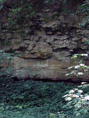
After a few hundred metres, I came across one of these quarried areas, where massive well bedded massive limestone is overlain by irregular, relatively formless masses that in places look like they are reefs – a feature that is noted in the 1947 geological memoir for the Barnsley district.
Unlike the well known reefs at North Cliff Quarry, Maltby Crags and Hooton Pagnell, these are much smaller in size and lack the large pillow like structures, which were described as saccoliths by the renowned geologist Denys Smith.
The sample that I collected from one of the more irregular masses is pale cream in colour, very fine grained and does not contain any ooliths, which are commonly found in the lower Wetherby Member of the Cadeby Formation. Viewed with a hand lens, it is granular in texture and contains no fossils, although there are dark grains that are probably a manganese oxide mineral.
Continuing along the path, which often veers away from the rock face and crosses ground that slopes steeply away from Hooton Cliff to the north but, even though obscured by trees and undergrowth, there are still glimpses of quarried faces at regular intervals.
In places, as I have seen in Anston Stones Wood and along the Don Gorge, there are slip rift caves, rock shelters and sediment filled fissures that are considered to have great archaeological potential, as well as being a possible source of Quaternary fossils.


No comments:
Post a Comment