 |
| An exposure of Mexborough Rock in Anston Brook |
At the northern end of Lindrick Dale, having already encountered some interesting geology at Brancliffe Grange and Wood Mill Quarry, the last leg of my walk from Shireoaks to South Anston started on the other side of the A57 - at the entrance to Anston Stones Wood near to the layby.
Entering the wood, the path passes through an area with dark brown soil and very little undergrowth, before dropping down into a wide valley where Anston Brook meanders to the point where it continues into Lindrick Dale.
The brook here has changed its course many times over the years and the flat valley bottom is covered in thick layers of silt, which is exposed in the stream banks. In places, the deposits seen in the banks mainly consist of head, with angular fragments of dolomitic limestone set within a matrix of finer grained material.
Continuing westward along this Public Right of Way, I passed under the railway bridge – which has a good example of the use of Staffordshire Blue engineering bricks and I soon arrived at another bridge, which the principal path follows over to the north side of Anston Brook.
When producing the Anston Stones Wood Geological Trail, more than 20 years ago, the route was designed to discourage visitors to keep to the established paths and not disturb the flora and fauna in this Biological SSSI (Site of Special Scientific Interest).
The crags and bryozoan reefs on the north side of Anston Brook were emphasised, particularly the local landmarks known as the Little Stones and The Cut, but a few other outcrops of the Cadeby Formation are now known to the Sheffield U3A Geology Group, the Yorkshire Mid Week Geology Group and others that know how to take care of the environment.
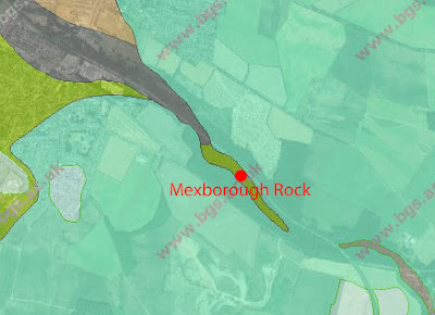
On the geological map, it can be seen that the gorge, which was formed about 12,000 years ago during the Quaternary Period, has cut through the Permian limestone of the Cadeby Formation to expose the Upper Carboniferous Mexborough Rock that lies unconformably beneath it.
During several previous visits to Anston Stones Wood, I had only seen a few small exposures of the Mexborough Rock in the stream banks, when commissioned by Rotherham MBC to undertake a detailed survey over 20 years ago and, as I carried along the path alongside the brook, I kept my eyes open for further evidence of this.
Having observed several cross sections where I could see small blocks of sandstone above the waterline and small slabs in the stream bed, which have a noticeably different colour to the fragments of limestone in the deposit of head above, I eventually came to a stretch of the stream bank where beds of flaggy sandstone were clearly visible.
 |
| An exposure of Mexborough Rock in Anston Brook |


No comments:
Post a Comment