 |
| Thinly bedded dolomitic limestone in Hawks Wood |
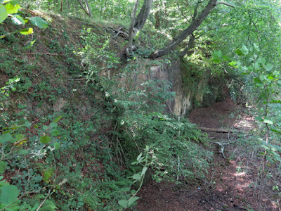
Entering Hawks Wood, following my walk along the Chesterfield Canal from Kiveton Park station, I took an unmarked path to the west and very soon encountered a shallow delph, where a section of thinly bedded limestone is exposed at its edge.
In this area, the upper subdivision of the Cadeby Formation (Sprotbrough Member) outcrops at the surface, with this being characteristically massive and wedge bedded. It is very rarely described in any of my memoirs for Sheffield, Barnsley and Doncaster as being thinly bedded or flaggy and, along with other similar roadside outcrops in Thorpe Salvin, it is the only place where I have seen limestone of the Cadeby Formation looking like this.
To the north side of the path, adjacent to the canal, there is a larger and much deeper quarry, where the quarry face exposes massive, thickly bedded limestone that is typical of the Sprotbrough Member. I think that is the site now recorded as a RIGS (Regionally Important Geological Site), following an assessment of it by the Sheffield Area Geology Trust, but I didn’t make any attempt to find access to it on this occasion.
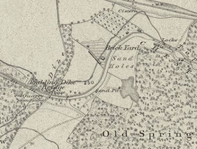
Returning to the Chesterfield Canal, I made my way along past Top Treble Lock and crossed Bridge 35 to Old Spring Wood, which appears on the 1854 Ordnance Survey map with Sand Holes and Sand Pit next to it.
These names would suggest that sand was dug from these places but, looking at the geological map, the underlying bedrock here is clearly shown as the Permian Edlington Formation and no superficial deposits are marked.
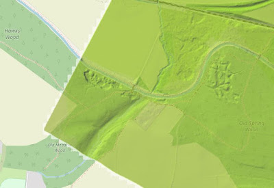
Looking at a LIDAR map, it can be clearly seen that this area of land has been excavated, as have the Brick Yard to the west of the Chesterfield Canal - which here has two very marked right angle bends in its course - and the Hawks Wood limestone quarry.
The calcareous mudstone
of the Edlington Formation has undoubtedly been exploited for making bricks here –
as it has in many other places in South Yorkshire and the East Midlands. I have seen only a handful of exposures of it in drainage ditches and old brick pits, where there has been marl and gypsum, but the Sheffield memoir mentions that it also contains sand near Thorpe Salvin.
I didn’t wander off the path to Thorpe Salvin to investigate the old workings in the wood here and, with the hope that I might be able to find some exposures of limestone in the steep sided valley that it has formed, I instead carried on in search of Pudding Dike.
Finding only a stagnant looking pond beside the sewage works and, with no obvious way to follow the Pudding Dike any further, I made my way up the hill towards Thorpe Salvin on the path that runs alongside the wood - stopping occasionally to take few photographs of the landscape to the east, where the Triassic Chester Formation sandstones form ridges on the skyline.
I noticed that the ploughed soil here contains many pebbles mixed in with the angular fragments of dolomitic limestone, with the single specimen that I collected looking like those that I had found a couple of weeks earlier at Brancliffe Grange, which have a glaciofluvial origin.
Although it has not developed the form of a dreikanter and is not very smoothly polished, this sandstone pebble has distinct facets and rounded edges, which have been shaped in a periglacial environment. Compared to the pebbles retrieved from the drainage ditch, where the high iron content of the soil would be a source of staining, it is also very pale in colour .


No comments:
Post a Comment