Arriving at the summit of the Chesterfield Canal at Thorpe Top Treble Lock, which is approximately 80 metres above sea level, having had one of the most enjoyable walks for a very long time, the second part of the walk to Kiveton Park station had less obvious attractions.
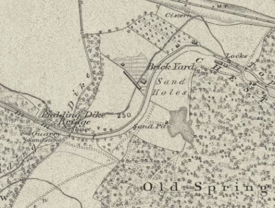 |
An old map showing quarry sources of building materials
|
Seeing only a derelict brick cottage through the trees here, with some rusting farm machinery, when later referring to the 1854 Ordnance Survey map I discovered that this area was a former brick yard, which dug marl from the Edlington Formation. I then came to the brick built mid-C19 Pudding Dike Bridge, which has an old quarry - erroneously described on the map as producing sandstone - immediately to the west of it.
 |
Pudding Dike Bridge
|
Beyond this point, the Edlington Formation appears to the north as an expanse of agricultural land with distinctly red soil – a geographical feature that I had noticed when looking from the window of the train a few hours earlier.
 |
Reddened soil on the Edlington Formation
|
When undertaking a survey of potential RIGS (Regionally Important Geological Sites) back in 1996, I was directed by the desk based researchers to investigate a potential exposure of the Edlington Formation near to the canal at Thorpe Salvin, but I didn't manage to find it.
 |
Devil's Hole Bridge
|
Carrying on to Devil’s Hole Bridge, which is the only stone built bridge that I saw on this stretch of the canal, I hoped that I might see a kingfisher or other wildlife but I had to be content with some very large dragonflies instead; however, I didn't even attempt to photograph them with the Canon Powershot G16 camera that I had with me.
 |
A glimpse of Anston Quarry in the distance
|
After a few more minutes of walking, I came within a short distance of the old Anston Quarry, which has no connection with the quarry that supplied stone for the Houses of Parliament, but I could only get a glimpse of an old quarry face in the distance.
 |
An undulating landscape on the Cadeby Formation
|
Shortly after this, there is a break in the woodland to the south where the undulating landscape formed by the Cadeby Formation can be clearly seen and, just before Thorpe Bridge, the 1924 Ordnance Survey Map shows an old quarry, but I was not aware of it at the time.
 |
Old quarries marked on the 1924 Ordnance Survey map
|
At Thorpe Bridge, there is a well made Peak and Northern Footpaths Society sign – the third that I had seen since starting my walk at Shireoaks – and further online investigation of these paths gave me a few ideas for further exploration around the Chesterfield Canal in the near future.


No comments:
Post a Comment