 |
| An escarpment of the Cadeby Formation at South Anston |
When planning my exploration of the Chesterfield Canal, I had intended to walk from Shireoaks to Kiveton Park station, where I would then catch the X5 bus to Sheffield; however, when coming to the very end of my walk, the bus came whizzing past before I could get to the bus stop.
 |
| The Anston parish boundary stone |
It was not yet 3 o’clock and having only walked 6 km, rather than hang around in this lifeless place, I continued my walk to South Anston, where I knew that I could catch this bus and have a beer at the Leeds Arms – a watering hole that I had used before when exploring the area.
 |
| Dog Kennel Hill |
I had never walked along this road before and, with this being the route that was taken by teams of eight horses that dragged stone from the Anston quarry to Dog Kennels, loaded on low, wheeled wooden platforms called ‘drugs’, I was interested to see what this would entail.
 |
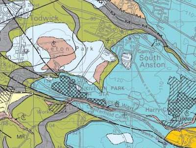
| The geology around Kiveton Park and South Anston |
From the top deck of the bus, it is possible to get glimpses of the large disused quarry in the Permian Cadeby Formation to the west of Dog Kennel Hill but, not being able to do so when walking, I was content to take in the views of the surrounding landscape and get a good appreciation of the landforms.
 |
| A view west to Kiveton Lane across till and head |
Once beyond the built up area and into open countryside, the bedrock geology changes from the Cadeby Formation to the younger Upper Carboniferous Mexborough Rock, which are separated by an unconformity, but the whole area is overlain by a blanket of Quaternary till and head.
 |
| An escarpment of the Cadeby Formation |
To the east, the escarpment formed by the Cadeby Formation can be easily distinguished and, in the distance to the south-east, the wooded landscape marks the position of the valley in which the Chesterfield Canal and the Sheffield to Lincoln railway are situated.
 |
| A view to the south-east across the Cadeby Formation |
To the west-north-west, Todwick can be seen on the skyline, with one of the Penny Hill wind turbines at Ulley far in the distance. Even though the crops were at an advanced stage of growth in the last week of July, the red soil that is characteristic of the 'Rotherham Red' variety of Mexborough Rock could still be seen in the agricultural land on the outskirts of this village.
 |
| Reddened soil on the outskirts of Todwick |
It didn’t take long before I arrived at the edge of South Anston, where I descended down a moderately steep hill that would no doubt have placed some strain on the horses that were pulling loads of stone up it.
 |
| Arriving in South Anston |
On Crowgate, there is a mixture of brick built inter-war detached and semi-detached houses and a few Victorian villas that are mainly built in local dolomitic limestone, but they don't have any great architectural merit and so I didn’t stop to photograph them.
 |
| Rotherham Red sandstone and limestone in a boundary wall |
Although limestone and red pantiles are the dominant vernacular building materials, Rotherham Red sandstone of unknown provenance is frequently mixed with the limestone in boundary walls. These show the relative durability of the two different stones, particularly when subjected to rising groundwater and road salt, and the colour variation of the sandstone is quite noticeable.
 |
| The Leeds Arms |
Finally arriving at the Leeds Arms public house, having given my name and phone number in accordance with the COVID-19 Pandemic regulations at the time, I sat outside by myself and enjoyed a leisurely pint of Abbot Ale in the afternoon sunshine.
 |
| A pint of Abbot Ale |
Very conveniently, the bus stop here is right outside the pub and, although I didn’t wander far up Sheffield Road, there is a good view of St. James’ church in the distance, which I had explored in detail a few years earlier.

No comments:
Post a Comment