 |
| In Attercliffe Municipal Cemetery |
The Royal Bank of Scotland building in Attercliffe is set alongside Attercliffe Municipal Cemetery and the former site of Christ Church, which was damaged in the WWII Sheffield Blitz and demolished shortly thereafter.
 |
| A lining of headstones to Church Lane |
A few years ago, while exploring a section of the Five Weirs Walk, I had a very brief look at the cemetery, which is accessible from the path that runs alongside the River Don and so I went to explore it further – after taking a few quick snaps of the line of grave slabs on Church Lane.
 |
| Blackened Victorian headstones |
Once inside the main part of the cemetery, I was struck by just how uniformly black the headstones generally were, with the various inscriptions looking as sharp as the day they were produced – with no obvious delamination or general degradation of the stones.
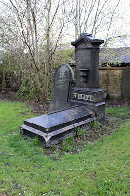 |
| The Chapman memorial |
I didn’t examine the headstones closely, but I saw some that were 150 years old and had therefore been subjected to the full onslaught of the pollution of the surrounding steelworks. One of the pale coloured granite monuments looked like it had been given a coat of shoe polish, such was the black shine on its surface.
 |
| A detail of the Chapman memorial |
It is a testament to the durability of the Greenmoor Rock, known in Sheffield as the Brincliffe Edge Rock, which gained a very good reputation for its high quality monuments, as well as paving, and it was available in good sizes.
 |
| A Victorian headstone |
Continuing down to the riverside, I was pleased to see that the WWII pillbox is still there, although it is a great pity that it is not listed – as a very rare example of Sheffield’s military heritage - and that it is now just a target for mindless graffiti.
 |
| A pillbox on the River Don |
When arriving at the riverside path, I was very surprised to see a surprisingly large vertical drop down to the River Don – with a substantial retaining wall - and also that there is a marked difference in the level of the lower west bank opposite.
 |
| A geological map of the area around Attercliffe |
Looking at the geological map of the area, it can be seen that this point coincides with the outcrop of a minor unnamed sandstone from the Pennine Middle Coal Measures Formation. Although no longer visible, a cliff of this sandstone would undoubtedly have been that depicted in the views of the old Christ Church – and which is said to be the origin of Attercliffe’s name.
 |
| The River Don at the rear of Attercliffe Municipal Cemetery |
Returning to Attercliffe Road, I carried on towards Rotherham and soon came across Hilltop Chapel, which I had visited a couple of years earlier when looking for the grave of Henry Clifton Sorby, but instead found that of Benjamin Huntsman and other monuments, where the grave slabs are some of the largest that I have ever seen.
 |
| Hilltop Chapel |
No comments:
Post a Comment