 |
| An outcrop of the Abdy Rock on Warren Vale |
During my investigation of the geology around Ockley Bottom, Kimberworth and Bradgate in the north-west part of Rotherham, I traversed a sequence of rocks that comprises the upper part of the Pennine Lower Coal Measures Formation (PLCMF) – from the Whinmoor Coal to the Vanderbeckei Marine Band – as seen on the British Geological Survey Sheet 87 map for the Barnsley district.
 |
| A section through the upper part of the PLCMF |
It consists of several sandstone members, including the Whinmoor Rock, the Silkstone Rock and the Parkgate Rock, which form distinct topographic features, along with intervening mudstones, bands of ironstone and coal seams - all of which were once widely exploited by the local iron and steel industry and used to build houses.
 |
| An exploration of 'Rotherham Roman Ridge' by Rotherham MBC |
For my next day out, I again used a leaflet on the Casual Ramblers website as the basis for my further investigation of the geology of Rotherham, this time to explore the Abdy Rock - the Pennine Middle Coal Measures Formation sandstone upon which Hoober Stand, one of Rotherham’s most recognisable landmarks, has been built.
 |
| A geological map of the area around Rawmarsh and Swinton |
The Rotherham MBC produced leaflet was one of a series that provided an introduction to a series of embankments that are marked on various Ordnance Survey maps as “Roman Road or Roman Ridge”, but which are actually considered to be the remains of Brigantian defensive earthworks known as the Roman Rig.
 |
| An Ordnance Survey map showing parts of the Roman Ridge |
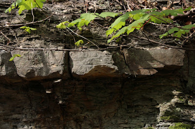
Except for surveys of potential RIGS in the area and a brief visit to the Rockingham Kiln, I hadn’t explored this area on foot, but I had noticed an excellent roadside exposure of the Abdy Rock on the former Rose Hill cutting (now Warren Vale), which the British Geological Survey 1947 memoir recorded as being an important section when it was excavated in 1931, as part of the upgrade of the road from Rawmarsh to Swinton.
 |
| A description of a rock section seen in the Rose Hill cutting |
Passing by it many times since on the bus, I have seen it slowly disappear behind the trees and undergrowth but, with plenty of it still visible, I decided to make this the start of my walk – this time with my next door neighbour Dan, who had accompanied me around Treeton earlier in the year.
 |
| The west side of the Rose Hill cutting |
No comments:
Post a Comment