 |
| A boundary wall at the south end of Main Street |
My main reason for visiting Palterton was to have a good look at the exposure of reddened dolomitic limestone of the Cadeby Formation at the south end of Main Street, before walking to Scarcliffe for the Heritage Open Day at St. Leonard’s church.
 |
| Palterton Hall |
As had become usual for my walks, I had also looked at the British Listed Buildings website to see if there were any buildings in need of a photograph and, after alighting from the bus on Back Lane, I had a quick look at some converted farm buildings at Castle View – built in cream coloured limestone with a red pantile roof - before cutting through a modern housing estate to Main Street, where I soon found the Grade II Listed early C18 Palterton Hall.
 |
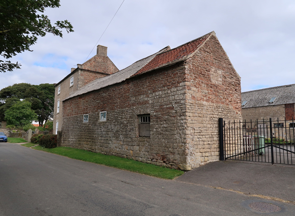
| Lilac Farmhouse |
It is built with yellowish dolomitic limestone from the Permian Cadeby Formation but, unlike the uniformly weathered massive limestone used for the late C18 Lilac Farmhouse, 50 metres further down the road, the walling stone contains softer beds that are differentially weathered.
 |
| A outbuilding to Lilac Farmhouse |
The south elevation of Lilac Farmhouse, as well as the upper section of the agricultural building attached to it, the upper part, is built in a well bedded red limestone similar to that I had previously seen in the outcrop further down Main Street.
 |
| A detail of the red limestone |
Zooming in to a section of the wall where the stones are not bonded, I could see that the limestone has proved not be particularly durable, with the weathered surface of the very exposed stone being exfoliated in very many places.
 |
| A large barn |
There is a large barn in the farmyard to the rear of Lilac Farmhouse, which is built entirely in cream/yellow limestone, but continuing along Main Street, the red limestone forms a considerable proportion of the masonry in the west wall of the neighbouring cottage.
 |
| The west end of a cottage |
Continuing along Main Street, various boundary walls are built in limestone typically seen in the Cadeby Formation, as is the former Mission Chapel and School House on the opposite side of the road, which was built c.1875 and has a simple grey granite war memorial in the plot next to it.
 |
| The old Mission Chapel and School House |
Opposite the chapel, the drive between two modern houses cuts through the well bedded red limestone, where the exposed rock forms the core of a roughly built boundary wall. It is a man made cutting, which improves access to the long strips of enclosed land and farm buildings between Main Street and Back Lane.
 |
| A cutting in the Cadeby Formation |
On Main Street, the modern garden wall obscures any rock that may have been visible, but it then reappears as a small vertical section that continues for several metres, before being interrupted by another cutting. This forms the north side of a roughly square piece of land, which has been described in Richards Bygone Times as “rock corner” and is the site of an ancient chapel dating back to the time of King Henry I.
 |
| The site of the ancient chapel in Palterton |
When I first visited Palterton very briefly, back in 1993, when undertaking stone identification and matching for English Heritage at Bolsover Castle, I just slowly passed by in the car and didn’t stop to take any photographs; however, I do recall that the rock face on Main Street was largely bare and I have always assumed that it is a natural feature.
 |
| An ivy covered rock exposure on Main Street |
Ivy now covers most of the rock exposure but, seeing glimpses of red limestone that looks so similar to that found in the buildings described above, as well as noting the various cuttings for tracks and the right angle turn on Main Street, it did make me wonder if there had been some planned landscaping of Main Street or very small scale quarrying in the past and that this stone has been used in local buildings.
 |
| An outcrop of red limestone in the Cadeby Formation |
Looking at the 1883 Ordnance Survey map, the nearest quarry that I could see was located a few hundred metres to the south-east at the junction of Losk Lane and Ling Lane. I don’t know this quarry, but Google Street View clearly shows that the road cutting here exposes a thinly bedded cream/yellow coloured limestone, which does not look particularly suitable for building.
 |
| A Google Street View on Losk Lane |
It is not unusual for stone for the better quality houses to have been brought from quarries up to 5 km away, which means that the quarries around Bolsover could be easily reached, but I have never seen any of them or know if any are still accessible.
 |
| Vernacular architecture on uphill Main Street |
Having achieved my objective of having another look at the Cadeby Formation and photographing the historic buildings on Main Street, I set off up towards Back Lane and immediately encountered another group of houses that are not listed, but are good examples of the local vernacular architecture. Unsurprisingly, cream/yellow limestone is mostly used, but I could also see the mysterious red limestone in the oldest part of one of them.
 |
| Red limestone in the lower part of an unlisted house |
No comments:
Post a Comment