 |
| Higger Tor |
Arriving at Froggatt Edge on the path from Curbar Edge, I immediately noticed the large quarry in the hillside near Grindleford on the opposite side of the Derwent Valley, which extracts the Kinderscout Grit that has been marketed as Stoke Hall stone. It has been used extensively in Sheffield for the Town Hall, the Peace Gardens and for dressings in very many of the Sheffield Board Schools and other historic buildings in the city.
 |
| The Stoke Hall quarry |
I only know this area from driving through it when living in Bakewell, or when taking the No. 65 bus from Sheffield to Buxton and I have not yet had the opportunity to visit this quarry, nor have I explored the village of Grindleford; however, at a great distance, I was able to zoom into Stoke Hall with my Canon G7X Mark II Powershot camera to provide a single photo for the British Listed Buildings website.
 |
| Stoke Hall |
Continuing along the path, there is quite a dramatic change in the surroundings. At the start of Curbar Edge, the landscape is dominated by bleak, heather covered moors to the east, with the gritstone edge overlooking head covered slopes that fall down to the River Derwent; however, much of Froggatt Edge is wooded and I soon lost sight of the rocky escarpment.
 |
| The southern end of Froggatt Edge |
A short distance further along the path in the woods, I encountered a stream that flows from Stoke Flat and cuts down into the head, exposing blocks of Chatsworth Grit. The red/brown colour at first suggests a high iron content in the rocks but, looking closely, the water is actually quite cloudy and it is possible that the colouration is derived from peat, which accumulates on the moors.
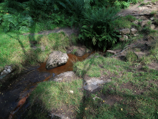 |
| Red/brown colouration of a stream at Froggatt Edge |
Walking along the path towards the A625, I noted further examples of flaggy beds within the Chatsworth Grit, which I had seen earlier at the beginning of Baslow Edge, but I didn’t stop to collect any more samples here.
 |
| Flaggy Chatsworth Grit exposed in the path |
On reaching the A625, having already had a good walk, I started to think about the best way of getting back home – either by train from Grindleford Station, where I would try out the renowned Grindleford Station Cafe or continue to the Fox House and have a pint of beer before catching a bus back to Sheffield.
 |
| The area around Nether Padley |
Deciding to carry along the public footpaths marked on my copy of the Ordnance Survey 1:25,000 map, to follow the escarpment, after entering Hay Wood the footpath became very difficult to follow. Although I could just about orientate myself, I wasn’t too far off getting a bit lost and I was therefore very pleased to come across Tumbling Hill, where I managed to get my bearings.
 |
| A panoramic view from Tumbling Hill |
Standing on the edge of an old quarry, there are good views of the landscape beyond Grindleford to the west and some of the distinctive landmarks that can be found on the Chatsworth Grit escarpment to the north, which includes Higger Tor and Carl Wark.
 |
| A view towards Hathersage Moor |
Making my way down to Oak’s Wood, I came across another stream that flows down from White Edge Moor. Having realised that it is impossible to obtain a sample from the rounded outcrops of the Chatsworth Rock in situ, without using a much larger hammer, I broke open one of the smaller pieces of rock that was lying next to the stream.
 |
| A stream at Oak's Wood |
Although the Chatsworth Grit forms erosion resistant landforms, the high feldspar content is broken down into kaolinite, particularly at the surface. Many of the smaller pieces of rock that I found, which have a large surface area compared to their volume, have a friable weathered rim.
 |
| A specimen of Chatsworth Grit from Oak's Wood |
No comments:
Post a Comment