 |
A gable end at Intake Primary School
|
In 1855, the Ordnance Survey map of Intake shows that it is a small hamlet at the junction of the roads to Mansfield and Handsworth, with various small coal pits, sandstone quarries, coke ovens and Woodthorpe Colliery appearing in a predominantly rural area.
 |
The 1855 Ordnance Survey map of Intake
|
From c.1800 to the beginning of World War I, the population of Sheffield grew exponentially to accommodate the growth of the production of steel and associated manufacturing and engineering industries and the 1894 map shows that Intake had grown considerably, with the Birley Collieries now requiring houses for their workers.
 |
The 1894 Ordnance Survey map of Intake
|
 |
The lodge at Intake Cemetery
|
 |
The chapel at Intake Cemetery
|
 |
The terrace of houses adjacent to Intake Cemetery
|
Immediately to the south of Intake Cemetery, a terrace of six houses is first shown on the 1924 map, with the Fidler Bros memorial masons at No. 89 being established in 1908. This and No. 91 have a different design to the other houses in the terrace and, as also evidenced by the lack of bonding between No. 91 and No. 93, it would seem that the standard design terraced houses were added to the pre-existing semi-detached house at a later date.
 |
89 and 91 Mansfield Road
|
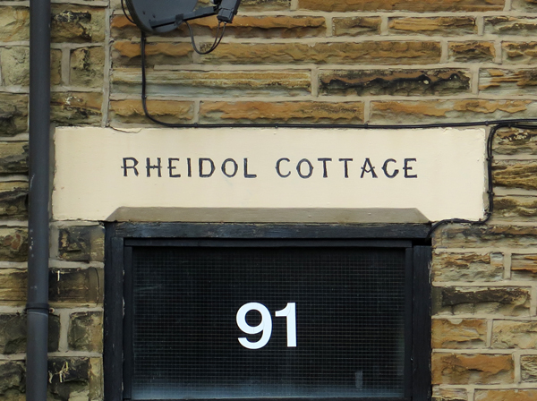
I didn’t closely examine the stonework of any of these with a hand lens, but subtle differences can be seen in the colouration of the sandstone used in these houses. Some have been cleaned or repointed with different styles and compositions of mortar, which affects the general appearance of the masonry as a whole, but to my eye there are noticeable variations in the individual stones.
 |
'Ginger nut' hued sandstone at Rheidol Cottage
|
For most vernacular buildings, local stone is almost invariably used and these usually give a good indication of the characteristics of the underlying sandstone and most of the stone that I saw in Intake was generally similar; however, Rheidol Cottage stands out because it is built in thin courses of ‘ginger nut’ hued sandstone, which is typical of Handsworth, and looks very different to the one used at No. 89.  |
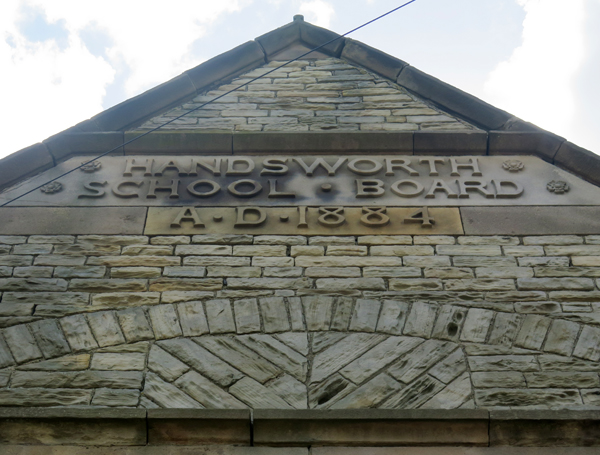
Intake Primary School
|
Across the road from the cemetery, Intake Primary School was built in 1888 for the Handsworth School Board, by an unknown architect, and uses a grey/light brown laminated sandstone for the general walling, with massive medium grained sandstone used for the dressings.
 |
Rotherham Red sandstone in a window jamb
|
Again I didn’t stop to closely examine the various sandstones used here but, at one point, I couldn’t help but notice that the distinctive pink/mauve Rotherham Red sandstone has been used for some of the window dressings and the plinth course. It looks very much like the stone seen at the old vicarage and St. Joseph’s Catholic church in Handsworth, where the latter is recorded as having used Treeton stone from Bole Hill.
 |
Rotherham Red sandstone window dressings
|
Carrying on down Mansfield Road, I then crossed back over to the junction with Hollybank Road, from where I could get a good a view of the vale in the middle. This is formed in the prefominantly soft mudstones of the Pennine Lower Coal Measures Formation, which then rises to the sandstone escarpment that I had followed down Normanton Hill.
 |
A view along Hollybank Road to Normanton Hill
|
Crossing back over Mansfield Road and then heading up Hollinsend Road to find the path to the Shire Brook, I came across the Wesleyan church, dated 1858, which provides another example of what I presume to be locally quarried Parkgate Rock.
 |
Hollinsend Wesleyan chapel
|


No comments:
Post a Comment