 |
| An outcrop of flaggy sandstone in Shirtcliff Wood |
When investigating the Shirtcliffe Valley, the path that I took didn’t initially run near to Shirtcliff Brook and, although I had been told by Pat Howells of the Friends of Shirtcliffe that there were rock exposures to be seen at the top of the escarpment to the north of the valley, I had set out with the hope of seeing some good exposures in the stream banks.
At Shirtcliff Wood, the character of the valley changes and the path closely follows the route of the brook, with slopes rising steeply on either side. Not knowing the geography of the woods or having my GPS device on me, as I would if I was undertaking a professional survey of the geology, I could only make a rough guess of the locations where I was taking photographs.
In the upper part of the Shirtcliffe Valley, Shirtcliff Brook flows downhill along the strike of the soft mudstones found in the Pennine Middle Coal Measures Formation here but, at Shirtcliff Wood, it cuts across the sandstone that had so far only been apparent as a wooded escarpment on the north side of the valley.
Like most stream bank outcrops found in established woodland, the underlying rocks are only sporadically exposed but there are enough exposures to be able to accurately determine the dip and strike of the strata using a compass clinometer. Wellingtons are needed here, but this would be expected of any A-level student or undergraduate geologist undertaking a mapping project.
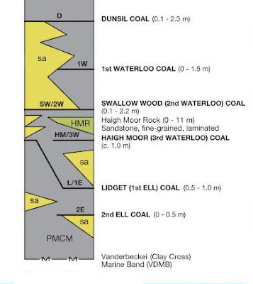
The geological memoir for the Sheffield district generically describes the strata beneath the Woodhouse Rock and Swallow Wood coal as follows: “The rocks are mudstones and siltstones with beds of ironstone, lenticular beds of sandstone, and as many as five thin coals”.
I didn’t collect any samples but I saw several examples of flaggy sandstone and siltstone in situ, with larger blocks of coarser grained sandstone littering the stream in places. Furthermore, the greater part of the south side of the woods was drift mined here and the Swallow Wood seam is reported as outcropping in the middle of the wood.
Apart from the geology exposed here, wild garlic grows in abundance alongside the brook, as in Treeton Wood, and although by the beginning of June it was way past its best and not worth foraging, I made a mental note to return in 2021 - when the bluebells will also be in flower.
Finishing my walk through Shirtcliff Wood, where I could easily conduct a short introduction to geology, I arrived at Beaver Hill Road where I discovered Flockton Park, another one of the very many Sheffield parks that I had never heard of before.


No comments:
Post a Comment