At the end of week 18 of the COVID-19 Pandemic travel restrictions, in the third week of July 2020, I had fallen into a pattern of doing essential shopping in midweek or on a Saturday and then taking some essential exercise on a Sunday.
For my next trip to investigate the geology, historic buildings and industrial history of the area within a ‘safe’ distance from Treeton, I identified on Google Map another part of the Shire Brook that I had not yet explored.
Taking the No.73 bus to Manor Top, I started by walking down Mansfield Road with the Parkgate Rock forming the high ground to my right, which I could see from the top of Hollybank Road during my previous investigation of Normanton Hill.
Manor Top forms one of the highest points on the Sheffield ring road, with good views, and in the distance can be seen the high ground beyond the M1 motorway to the south-east, which is formed by the Pennines Middle Coal Measures Formation strata – in particular the Mexborough Rock.
At the junction with Foxwood Road in Intake, the former Primitive Methodist Church here - originally built in 1874 - was enlarged in 1886, with pitch-faced laminated sandstone used for the walling and a more massive sandstone used for the dressings. It is not a listed building or mentioned by Pevsner, but it nonetheless has some interesting architectural features.
The masonry has been partially blackened but its greyish colour, with rusty coloured Liesegang rings and dense brown accumulations that formed along joints, can be clearly seen. These characteristics are apparent in both the walling and dressings and it is very probable that they came from different beds within the same quarry.
As with most building stones, unless they possess very distinctive physical characteristics that make them easily recognisable, without documentary evidence it is extremely difficult to pinpoint a quarry source. Also, as I had recently discovered at St. James' church in Woodhouse, with the coming of the railways, stone could brought be brought in from a considerable distance.
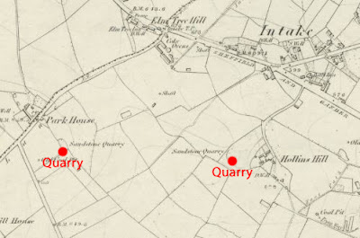
On the 1855 map, a sandstone quarry is marked just to the south of the site of the future church. It is included in the national Directory of Mines and Quarries of 1897 and recorded in the Whites Directory of Sheffield & Rotherham, which suggests that it was a well established business.
Between 1855 and 1894, various terraced, semi-detached and detached houses were built along Mansfield Road, including Intake Villa in 1878. The latter has laminated sandstone walling stone, which is very probably local, but the pinkish massive sandstone used for the quoins is not typical of those found in the area.


No comments:
Post a Comment