 |
| A sample of weathered mudstone from Shirtcliff Brook |
At the end of week 51 of the COVID-19 Pandemic, having recently had a good look at the historic architecture and building stones of Crookes and Walkley, I took advantage of a mild Sunday afternoon at the beginning of March to further investigate the geology of the Shirtcliffe Valley.
A couple of months earlier, I had a good look at the exposures of the various Pennine Middle Coal Measures Formation strata in the bed and banks of Shirtcliff Brook and, before the undergrowth reappeared in force, I wanted to see if I could get down into the streambed and obtain a sample of the very coarse sediment that had been laid down in the Holocene Epoch.
Realising that I would need Wellington boots to further explore this section of the brook, I gave up on this idea and headed up to a part of the Shirtcliffe Valley that is known as The Edge, where I had previously seen a few small exposures of a sandstone formerly named the Woodhouse Rock.
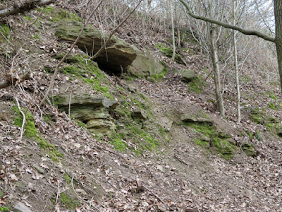
Scrambling up to the most easily accessible of these, I could quite clearly see the difference between the fine grained sandstone and the silty sediment that lies beneath it – with the subtle variations in the grain size and bedding being highlighted by differential weathering.
Gaining access to the higher exposure, which is not as easy as it looks, this variation is much more pronounced – with the thinly bedded sandstone here being deeply undercut to reveal a siltstone that contains very distinct ripples.
After collecting a piece of sandstone with my Estwing hammer, I then proceeded along the path below the escarpment, passing exposures of slightly more massive sandstone that I had not seen during my visit the previous summer. I saw no sign of the quarry that was marked on old maps and carried on to the Shirtcliff Brook in Smelter Wood, where a footbridge crosses over it.
Immediately downstream of the footbridge, there are good exposures of siltstone and mudstone in the stream banks and streambed, which are much more accessible than the exposures seen much further downstream in Shirtcliff Wood.
Although I needed to take care when getting in and out of the brook, I was able to make my way along the streambed without the need for Wellington boots and, with my hammer in hand, I soon found a suitable place from which to obtain a sample.
Having chipped off a piece of mudstone from just below the water’s surface, I pulled it apart to reveal a deep orange gelatinous substance full of iron oxides/hydroxides - breakdown products of the weathered mudstone that I had not encountered before.
After discovering that I could easily crumble the mudstone with my fingers, I decided not to collect a specimen on this occasion and went to have a look at the exposures a little further upstream, which have turned into yellow clay – a common feature of the stream banks where the fine grained Pennine Coal Measures Group strata are exposed.
In other locations, the coarser grained grey siltstone looks very similar to the walling stone that surrounds the south door at St. Mary’s church, which has also been used for boundary walling in nearby Handsworth; however, I again didn’t collect a sample and carried on upstream to have another look at the small outcrop of the Swallow Wood coal seam.
 |
| An outcrop of the Swallow Wood coal seam |


These short excursions are rather fun. Thanks for blogging.
ReplyDeleteFollowing along on these excursions is rather fun. Thanks!
ReplyDeleteThanks eliz3. I am glad that you enjoy them - there are plenty more in the pipeline... :-)
ReplyDelete