 |
| Rocks collected on the walk from Kiveton Park to Todwick |
On a few occasions, when exploring the area around the Chesterfield Canal during the summer of 2020, I came across places on the Magnesian Limestone where the fields were strewn with rounded and sometimes faceted pebbles of Carboniferous sandstone.

These are not marked as superficial deposits on any map, but the Geological Survey of Great Britain memoir, published in 1957, mentions in the introduction to Pleistocene and Recent deposits that there are “a scattering of pebbles to show where more substantial deposits must have been” – with these being found on high ground.
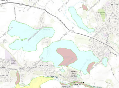 |
| Superficial deposits in the area around Kiveton Park |
For my next day out, following my investigation of the Treeton Rock, I planned a walk that followed various public footpaths across a part of rural Rotherham, where the British Geological Survey map shows that the bedrock is covered in till and head - laid down during the Quaternary Period.
 |
| An Ordnance Survey map showing footpaths around Kiveton Park |
In the area covered by the Sheet 100 Solid and Drift 1:50,000 geological map, less than a handful of sections of till had been recorded, with it being mostly necessary to map the till by observing areas of clayey soil with concentrations of erratics.
 |
| The public footpath to South Anston |
Arriving on the X54 bus at the stop nearest to Kiveton Farm Fisheries and walking east towards South Anston, the ploughed fields presented a featureless landscape that sloped up to the Magnesian Limestone escarpment in the distance; however, there was no sign of the typically reddened soil from the underlying bedrock, which here is Rotherham Red sandstone.
 |
| An exposure of loamy soil adjacent to the footpath |
At the edge of the well used wide track, which has been repaired/reinforced in brick and possibly other materials, bare patches of light brown loamy soil are seen to contain numerous pebbles of various shapes and sizes – most of which looked similar to the Carboniferous sandstone pebbles that I had previous seen and interpreted as being glaciofluvial in origin.
 |
| Loamy soil with abundant pebbles |
Carrying on along the track, looking in the soil that could be seen beneath the crop that was now growing in mid-March, within a few minutes and over a short distance, I also found pebbles of vein quartz, red and brown quartzite and others that I thought might possibly be igneous - and pieces of granite and volcanic green slate that are probably building materials.
 |
| A broken pebble of quartzite |
Their polished nature makes it difficult to positively identify these pebbles and, although one that I was able to break open with my Estwing hammer was revealed to be a quartzite, others would not break under sustained hammer blows.
 |
| An old quarry at Kiveton Park |
I then took a diversion to Lodge Hill Pond, where a large erratic of volcanic agglomerate from the Lake District had been recorded, but I couldn’t find it and continued south to quickly look at the old quarry to the north of Kiveton Park station, before returning back to the track to South Anston.
 |
| Fragments of Rotherham Red sandstone in ploughed soil |
I had so far crossed over the areas of both till and head, without seeing any difference between them - which may be possible when crops are not growing. Turning northwards onto the path that marks the boundary between Anston and Todwick, I noticed that the pebbles had disappeared, the reddened soil above the bedrock had reappeared and the only rock fragments visible were small pieces of Rotherham Red sandstone exhumed by ploughing.
 |
| Fragments of Rotherham Red sandstone |
Arriving at the path that runs eastward into Axle Lane and South Anston, I followed it to the west and, after stopping to photograph the Magnesian Limestone escarpment to the north, I carried on along the path next to the ploughed field until I reached Todwick.
 |
| A view north towards the Magnesian Limestone escarpment |
No comments:
Post a Comment