Monday 29 March 2021

Building Stones in Worksop - Part 2

 
A drinking fountain at Worksop Town Hall
 
Continuing my exploration of the historic architecture and building stones of Worksop, having passed by a magnificent example of green architectural faience produced by Burmantofts of Leeds, at the French Horn Hotel, I reached the end of Potter Street.
 
A detail of the French Horn Hotel

Here, Worksop Town Hall, dated to 1851 and originally built as the Corn Exchange, has a south elevation that has the upper levels built in red brick, with massive buff sandstone – displaying some red colouration - used for the vermiculated and rusticated masonry to the ground floor, the quoins and the window dressings.
 
Worksop Town Hall

The drinking fountain at ground floor level is made of grey granite from the Cornubian batholith in south-west England, with distinctive large crystals of white feldspar, and Red Mansfield sandstone panels used for decorative effect.
 
The drinking fountain at Worksop Town Hall
 
The west elevation of the town hall is very austere, compared to the front elevation, and has an upper section of built of red brick and a ground floor of yellowish limestone, which is squared and coursed but not of ashlar quality.

The west elevation of Worksop Town Hall

Opposite the south-west corner of Old Market Square, which is only 200 metres from the site of Worksop Castle, the Old Ship Inn - dating to the C16 - has a south wall that is built out of another thinly bedded cream/pink limestone.
 
The Old Ship Inn

Having had a good walk around areas of Worksop that I hadn’t seen before, I then headed north along Bridge Place. There are numerous listed buildings dating to the C18 and C19 here but, with most of these being built with brick and often rendered, I didn’t take too much notice of them.
 
A view north along Bridge Place

The most ornate buildings are the Victorian banks, some of which are still in use, and these are mainly built in medium grained sandstone ashlar, with elaborately carved details. Often used together with polished granites, the architects took advantage of the growing railway network in the C19 to specify the best quality sandstone from places like Darley Dale in the Derwent Valley.
 
Barclays Bank on Bridge Place

Noting the stone used to restore the parapet at Barclays Bank, I took a diversion to Memorial Avenue to have another look at the Portland limestone and grey granite war memorial and the area around Worksop Central Library, which I hadn’t yet seen, before my investigations were cut short by the rain that was beginning to fall.
 
Worksop War Memorial

Having only enough time to quickly photograph the library and the grey granite horse trough outside it, I decided that a walk around The Canch park would have to wait for another day and I headed across to ASDA  - to take shelter from the rain and do some essential shopping before continuing to the railway station.
 
Worksop library and the horse trough

My final stop of the day was at St. John’s church on Gateford Road, where I was particularly interested to see the difference between the very pale grey/white dolomitic limestone used in its original construction – thought to be from Lady Lee quarry – and the pale cream/yellow variety used for the restoration to the west door.

The restored west door of St. John's church

Sunday 28 March 2021

Building Stones in Worksop - Part 1


Worksop Priory Gatehouse

At the end of my walk from Shireoaks to Worksop, along the Chesterfield Canal, a stretch of walling on the opposite side to the tow path at Matalan caught my eye because - along with the adjacent and overlying masonry - it is built of a stone that is very unlike the dolomitic limestone that has been used in the locks and bridges that I had so far seen along the canal.
 
Dolomitic limestone opposite Canal Road
 
Being unable to examine it, I carried on along Canal Road until I reached Kilton Road, where I noticed the former Royal George public house, which is set immediately next to the canal bridge. It is built in dolomitic limestone, brick and another stone that I did not obviously recognise and I couldn't safely investigate with my hand lens, steel knife and hydrochloric acid.
 
An agricultural building on Kilton Road

Nottinghamshire is underlain mainly by Triassic rocks, from which only the Keuper Waterstones and Skerry Sandstone from the Mercia Mudstone Group have been widely quarried for local use, but the British Geological Survey map of old building stone quarries doesn’t show any in the vicinity of Worksop.
 
On the opposite side of the road, a C19 red brick built old brewery has dressings of another yellow coloured stone, which this time I positively identified as the Permian dolomitic sandstone known as White Mansfield stone.
 
Dressings in White Mansfield stone

Now unavailable, I once spent a few months sawing this stone at the Gregory's Quarry and the green clay beds within it are typically differentially weathered to leave a texture like old wrinkled leather. This stone was used widely in the East Midlands and gained a national reputation in the C19 and, in Worksop, it has been used for the modern extension to Worksop Priory.
 
Weathering of clay beds in White Mansfield stone

Continuing my exploration of Worksop, I walked down Priorswell Road past the River Ryton and the priory, without stopping at the latter, and took a couple of photos of Worksop Priory Gatehouse, which is is built in yellowish and sometimes pink dolomitic limestone from the Cadeby Formation, as I had seen on Kilton Road.
 
Worksop Priory Gatehouse

Walking along Potter Street, Nos. 138 and 33-35a and various boundary walls are obviously pale cream dolomitic limestone but various other boundary walls have yellow to pink colour variation, which are sandy in appearance and need close examination.
 
Houses on Potter Street

Along the Magnesian Limestone escarpment, from Pontefract in West Yorkshire to Clowne in Derbyshire, I have seen examples of the Cadeby Formation that vary from very pale cream to yellow/pink in colour. The latter are usually found when the Cadeby Formation is underlain by the Yellow Sands Formation, with variable quantities of sand being incorporated into the limestone.
 
Boundary walls on Potter Street

Tuesday 23 March 2021

A Walk From Shireoaks to Worksop

 
A detail of a rebuilt brick pier at Canal Wharf

Week 24 of the COVID-19 Pandemic in 2020 coincided with the last week in August and, having travelled a few times on the Sheffield to Lincoln train quite safely, the trip following my Kiveton Park to Thorpe Salvin circular walk again started at Shireoaks.
 
On this occasion, I planned to walk along the Chesterfield Canal to Worksop, which I had first visited in 2016 - to specifically see Worksop Priory - and whose principal historic buildings and main points of interest I had already seen.
 
The Chesterfield Canal at Shireoaks

Having noted on Google Map that this stretch of the canal had an industrial rather than a rural character, I set off on my walk more in hope than expectation – at least as far as my interests in geology and historic buildings were concerned.
 
Various bridges and locks on the Chesterfield Canal

Although I did stop to photograph various bridges that crossed over the canal, I quickly walked to Worksop and it was only when I later looked at various maps that I got a better appreciation of the industrial history here - particularly the exploitation of the underlying mineral resources.
 
The Lady Lee limestone quarries and limekilns on the Cadeby Formation to the south of Rhodesia were once served by a now infilled spur of the Chesterfield Canal, marked by a brick bridge, and both brick works and various sand pits were located on the Edlington Formation – which in the Worksop area has a soft sandstone in its upper part.
 
A commemorative plaque at Canal Lock

Large squared blocks of dolomitic limestone are used along the length of the canal from Shireoaks to the centre of Worksop and, at Canal Lock, a rough untooled boulder of limestone, with a plaque fixed to it, marks the bicentenary of its opening.
 
The Pickford's Depository

Continuing along the towpath under Bridge Place, I came to the old Pickford's Depository which, like the nearby Canal Cottage, was built in the early C19 with pink/orange/yellow coloured bricks and Carboniferous sandstone dressings.
 
Various red brick buildings in Worksop

The bricks are markedly different in colour and texture to the bricks that are used for most of the older buildings that I have seen in Nottinghamshire. The Permian marls here have been widely exploited to produce typically red bricks, but those seen at Canal Wharf have more in common with the calcium rich/iron poor bricks made from the younger Jurassic and Cretaceous strata further to the east.
 
A detail of a rebuilt gate pier

Friday 19 March 2021

From Thorpe Salvin to Kiveton Park


A view of St. Peter's Church from Lady Field Road

The last leg of my circular walk, from Kiveton Park station to Thorpe Salvin, involved a 2 km walk from St. Peter's church along Lady Field Road – passing an area of agricultural land on a plateau of generally horizontally bedded dolomitic limestone of the Cadeby Formation.
 
The geology between Thorpe Salvin and Kiveton Park station

On the geological map, Lady Field Road is seen to cross a fault, to the immediate south of which is marked the calcareous mudstone that forms the lowest strata of the Cadeby Formation. The road then continues along the line of this fault for a short distance, with the Permian Cadeby Formation to the north and the Upper Carboniferous Mexborough Rock to the south.
 
A viiew towards Harthill

Setting off from St. Peter’s churchyard, after taking a photo of the north elevation of the church, I soon realised that I probably wouldn’t see much from this stretch of road, as I took in the views across the wheatfields towards Locscar Wood and Harthill to the south-east.
 
A roadside exposure of dolomitic limestone

The geological map shows a small expanse of Quaternary till straddling the road but, not seeing any exposures of soil next to the roadside, I just carried on until I reached the farm at Bunker’s Hill, which is built on the site of an old quarry.
 
A detail of a roadside exposure of dolomitic limestone

Noting the position of a bridleway on the north side of the road for future walks, I photographed the small outcrop of limestone that is exposed immediately below the hedgerow but, except to record its rubbly nature, I didn’t examine it closely.
 
A view north towards the Chesterfield Canal

Continuing down the hill and crossing the Carboniferous/Permian unconformity that separates the Cadeby Formation and the Mexborough Rock, apart from a change in slope at the foot of the limestone escarpment, I couldn’t see much evidence of this in the soil or vegetation.
 
A view across the Carboniferous/Permian unconformity

Walking for a few minutes more, I then stopped at Peck Mill View where, looking to the south-east, the red soil covering the rising ground clearly marks the position of the underlying ‘Rotherham Red’ variety of the Mexborough Rock.
 
Reddened soil on the Mexborough Rock

Arriving at the crossroads at the bottom of Lady Field Road, the Mexborough Rock continues to produce a noticeable landform, with a gentle escarpment running parallel to Manor Road in an east-west direction.
 
The Mexborough Rock at Manor Lane

Finally reaching Kiveton Park station, after a leisurely 4 mile walk that had taken just under 3 hours, my timing was just right on this occasion and I only had a couple of minutes to wait before the X5 bus arrived to take me back towards Treeton.
 
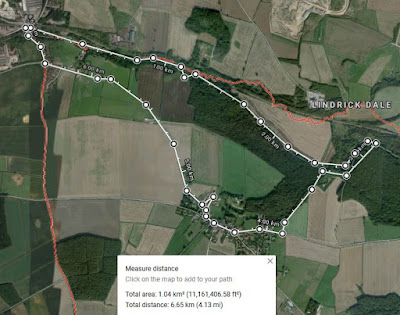
My circular walk from Kiveton Park station to Thorpe Salvin

Once on the bus, I checked the bus timetables on my mobile phone to see what route home I should take. Finding that there were no connections without a long wait, I decided to stay on the bus all the way to Sheffield Interchange. Here, I took advantage of the late afternoon sunshine at the Old Queen’s Head, where I reflected on the various geology and architecture that I had seen earlier - with a couple of pints of Thwaites’ Wainwright.

Relaxing at the Old Queen's Head

Wednesday 17 March 2021

Geology in Thorpe Salvin

 
Flaggy limestone on Harthill Road

When I first visited Thorpe Salvin back in 1997, it was to undertake a survey of the roadside limestone quarry on Slaypit Lane, which is just a few hundred metres to the south of the village. I remember being very surprised at seeing a thin bedded limestone in the Cadeby Formation here, as well as it forming the foundations of the churchyard wall.
 
A barely visible roadside exposure on Worksop Road

During my exploration of the architecture in the village in August 2020, having arrived along the path from Hawks Wood - where the limestones in the delph are also thin bedded - I came to a grassy bank on the south side of Worksop Road, where more thin beds of limestone are exposed near to the level of the road.
 
A roadside exposure on Worksop Road

Walking further towards the centre of Thorpe Salvin, there are no obvious slopes or ridges in the road but, at the Parish Oven public house, there is a distinct slope that runs down to the junction of Harthill Road/Lady Field Road – with the churchyard occupying the corner site.
 
Limestone beneath the boundary wall to the Parish Oven
 
On both sides, it would appear that the road has been cut into a minor ridge of limestone, with no more than a metre of thin, irregular beds of rubbly limestone being exposed in various sections along the roadside cuttings.
 
Boundary walling at the Parish Oven

The various sections of boundary walls here, which are built on and against these outcrops, use blocks with bed heights that are much greater those seen in the in situ exposures of limestone. As a leader of field trips with the Sheffield U3A Geology Group, I think that this would be a great stop on any guided tour of the village. 
 
A rock outcrop and boundary walls on Worksop Road

Looking at the various shapes and sizes of the individual stones here, it is quite clear that the underlying bedrock in Thorpe Salvin could not have been used for the boundary walls and houses. A little further down the slope, the Coronation Garden provides another example of the thinly bedded Cadeby Formation.
 
The Coronation Garden

The section here has rubbly limestone, which may reflect desiccation and shrinkage, overlying massive limestone with well defined bedding planes. It reminds me of some of the sections that I have seen at Roche Abbey, where the mainly massive limestones of the Wetherby Member are interspersed with rubbly and honeycombed beds.
 
A detail of the outcrop in Coronation Garden

Continuing down Harthill Road, the churchyard wall and the boundary wall opposite are both built directly on flaggy limestone. Again, there is a great contrast between the thickness of the in situ beds and the building stones that have been placed on top of them.
 
The churchyard wall on Harthill Road

Not having a microscope or access to any laboratories or institutions, I have never yet seen a thin section of dolomitic limestone from the Cadeby Formation, nor have I collected any rock samples from the very many exposures that I have visited; however, on the outcrop scale, it still holds many great surprises and I continue to learn about its variability in the field.
 
A detail of the churchyard wall