 |
| The Stepping Stones |
When I signed up for a place on The Rivers Team coach for the Rotherham Deanery Pilgrimage to Bolton Abbey and Skipton, I particularly looked forward to seeing the ruins of Bolton Priory but I didn’t expect to encounter some interesting geology during my day out.
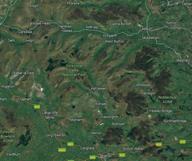 |
| The topography of the Yorkshire Dales as seen on Google Map |
I don’t know the Yorkshire Dales very well, having only spent a week camping at Hawes in Wensleydale – when I briefly visited Richmond, Castle Bolton, Aysgarth Falls, Thwaite and Muker on the Pennine Way and Malham Cove.
 |
| Glacial till around Bolton Priory |
The geological map of the area shows that Bolton Priory lies at the junction of the Bowland Shale Formation and the Pendle Grit Member, with much of the area being covered with Quaternary till, glaciofluvial sand and gravel and river terrace deposits.
 |
| A beach of shingle and cobbles on the River Wharfe |
When undertaking geological surveys for Doncaster MBC and investigating mediaeval churches at Thorne, Kirk Sandall and Hatfield I had encountered large rounded cobbles of similar origin in their walls, which were collected from the nearby fields.
 |
| Shingle and cobbles downstream of the pedestrian bridge |
The landscape of the lowlands of Doncaster contrasts strongly with Upper Wharfedale, which has been glaciated, with wide U-shaped valleys. The products of erosion have been concentrated in these valleys and at Bolton Priory, large expanses of shingle, cobbles and small boulders have accumulated on the inside curves of meanders in the River Wharfe here.
 |
| Shingle composed of Carboniferous Limestone and Millstone Grit |
A briefly examination of these reveals a mixture of Carboniferous Limestone and Millstone Grit, with the generally smaller size of the former reflecting the greater distance that they have been transported by the river. The River Wharfe rises approximately 35 km upstream from Bolton Priory at Beckermonds and cuts through Carboniferous Limestone for 25 km, before it encounters the Millstone Grit just north of Drebley.
 |
| A geological map of Upper Wharfedale |
I only spent five minutes on the west bank of the river, downstream from the pedestrian bridge, looking for some suitable specimens to take home with me and was very interested to come across the occasional pebble of black mudstone.
 |
| Gritstone, limestone and mudstone collected from the River Wharfe |
The reason for their rarity soon became obvious when the first one that I picked up fell to pieces in my hand, but I still managed to add one to my rock collection – in addition to banded gritstone and limestone with Lithostrotion coral.
 |
| A riverside exposure of the Bowland Shale Formation |
The source of the mudstone is the Bowland Shale Formation, which the River Wharfe traverses for a short distance in the locality and can be seen in the opposite bank of the river. Here the beds are near vertical, associated with the Skipton anticline, with a cliff formed along the line of a fault, and a short distance downstream there is a small spur composed of Millstone Grit.
 |
| Outcrops of the Bowland Shale (L) and the Pendle Grit (R) |
I have since learned that upstream from Bolton Priory, there is some more interesting geology and geomorphology – including The Strid – which I would like to investigate one day, possibly with the Sheffield U3A Geology Group.
 |
| The bridge over the River Wharfe at Bolton Priory |
No comments:
Post a Comment