 |
A detail of No. 6 Snaithing Lane
|
After my unexpected quick look at the interior of the Church of St. John the Evangelist, while waiting for Gerald Eveleigh - the Secretary of the Ranmoor Society - to arrive on the bus from Sheffield, I passed the time by briefly surveying the exterior of the church.
 |
Views of St. John's church
|
Walking down to the Ranmoor Inn, I took a few photos of the sandstone setts that were once obtained from several named sandstone formations in Sheffield, particularly the coarse grained Loxley Edge Rock, which are here edge bedded and some have distinctly laminated beds that have differentially weathered.
 |
Road setts at the Ranmoor Inn
|
Finally meeting Gerald, we headed up Ranmoor Road and stopped briefly at his terraced house on Deakins Walk, to collect a copy of an old map that he gave to me. The house was built some time between the publication of the 1855 and 1894 editions of the Ordnance Survey (OS) map and in the same period the quarries beneath Ranmoor Cliffe Road, which were marked on the earlier map, are no longer shown.
 |
A terraced house on Deakins Walk
|
I suspected that this terrace of houses may have been built with sandstone from one of these quarries but, without detailed documentation with precise dates of the operation of the quarry and the building of the various houses it is impossible to determine those that were built from the local Crawshaw Sandstone or others that used stone brought in from further afield.
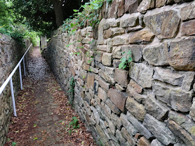 |
The snicket leading to Ranmoor Cliffe Road
|
Continuing past various buildings on Ranmoor Road that I had seen on my previous visit, Gerald then proceeded to take me along a snicket that rises quite sharply up the escarpment formed by a small outlier of Crawshaw Sandstone - marked on the 1855 OS map as Rand Moor Cliff.
 |
The snicket leading to Ranmoor Cliffe Road
|
Presumably the walling stone would have been supplied by the adjacent quarry, but I didn’t stop to examine it closely and we just continued past the base of the escarpment, where I looked for remaining exposures of the Crawshaw Sandstone but could not see any anything.
 |
The site of an old quarry in a back garden
|
Reaching Ranmoor Cliffe Road, we turned left and walked alongside the boundary wall above the site of the old quarry, which are presumably again built with sandstone from here. Without closely examining it, it appears medium grained with some iron staining, but does not seem to possess characteristics that clearly distinguish it – as can be seen in the very coarse grained Chatsworth Grit that is often seen for gate posts and coping stones in the area.
 |
A boundary wall on Ranmoor Cliffe Road
|
Looking over the boundary wall, I could see various lumps of sandstone scattered on the ground and, using a fallen tree branch, I managed to obtain a couple of pieces. In these, I can see cross-bedding, degraded iron bearing minerals that form concentrations along the joints and fractures in the rock and very occasional flecks of muscovite mica.
 |
Specimens of sandstone
|
We continued along Ranmoor Cliffe Road to Staithing Lane, an area of land that was purchased by the South View Society - formed in 1876 - but which actually contains very few Victorian houses. Although Ranmoor quickly became one of the most desirable places to live in Sheffield, as well described by Nyra Marie Wilson in her Thesis, very many of the plots in its western part remained unsold well into the C20.
 |
No. 6 Snaithing Lane
|
Gerald then took me to have a quick look at a friend's house, Snaithing Farm, which is marked on the 1855 map and, being within a few hundred metres of the Ranmoor quarries, is likely to be built out of the local Crawshaw Sandstone.
 |
Snaithing Farm
|
Continuing down a public footpath that cuts through to Snaithing Park Road and walking a short distance to Belgrave Road, we stopped at the unlisted Ranmoor Hall (1881), which was built for William Wheatcroft Harrison, who manufactured electroplated silver cutlery - first produced in Sheffield by his father John.
 |
Ranmoor Hall
|
From outside the entrance gates, it wasn’t possible to properly see the house and I just took a few photos of the gatepiers and the lodge, which is decorated by a crest, before we headed back to Ranmoor Road, where we briefly stopped at a later Victorian house that has not been built on land that was owned by a Land Society.
 |
No. 92a Ranmoor Road
|
The terrain on parts of the developed area in and around Ranmoor was often quite rocky and hilly and, as I had seen in many of the gardens of the larger houses along Fulwood Road, large rocks cleared from the land to make way for building have been used for landscaping.
 |
A modern house adjacent to No. 92a Ranmoor Road
|
The Ranmoor Land Societies imposed very strict guidelines relating to architectural style, materials and the size of plots, which gives Ranmoor Conservation Area its special character. Although relatively dense development from the C20 onwards has introduced a range of architectural styles from different periods, the modern house next to No. 92a Ranmoor Road – if it wasn't set well back from the road – could be considered as being incongruous.
 |
No. 1 Chapel Terrace
|
My very quick guided tour of Ranmoor ended at Chapel Terrace, which is the nearest I got to the old quarries, although I didn’t get near enough to see if any exposures existed on the slopes within the wooded area to the rear of the terraced houses, some of which were built for workers at the quarry and appear on the 1855 Ordnance Survey map.
 |
Quarry worker's houses on Chapel Terrace
|


No comments:
Post a Comment