 |
The base of a dolomitic limestone crag
|
 |
The railway bridge
|
We immediately came to the railway bridge, where the skew arch is built with Staffordshire Blue engineering bricks and which still forms an integral part of the still active minerals railway that runs along most of the length of the wood. Carrying on along the path that runs alongside the brook for much of its way, a few crags can be seen from a distance but they are not easily accessible.
 |
Anston Brook
|
For some distance, the only rock to be seen is in the streambed and stream banks, where small outcrops of the flaggy Rotherham Red variety of the Mexborough Rock can be seen. Over the years, especially after the heavy rain and flooding that Rotherham has experienced in the last few years, more of this has been exposed and there have been changes to the stream profile.
 |
An uprooted tree
|
At one point on the path, a large tree had been uprooted, which had disrupted and blocked the path, necessitating a short diversion up what turned out to be quite a slippery slope, after the most recent period of heavy rain.
 |
A large slipped block
|
Although very often covered in very thick vegetation, many large blocks have slipped down the hillside due to the process known as cambering, following the erosion of the gorge and undermining of the hard limestone by fast flowing water from a melting ice sheet to the west during the Quaternary Period.
 |
Crags on the south side of the gorge
|
The Anston Stones Geological Trail did not include the crags that run along the south side of the gorge because, as a Biological SSSI, English Nature preferred that the trail should follow the principal paths on the north side and not encourage general exploration of the areas off the footpaths; however, various geological groups and societies know that these have considerable interest and access to these is not difficult.
 |
A view along the base of the crags
|
The Wetherby Member of the Cadeby Formation is exposed here and the thinly bedded limestone that forms the base of the crags has been differentially eroded to leave a distinct overhang. All along the rock face, there are signs of the development of flowstone and in one place a detached block is joined to the bedrock by a stalactitic growth.
 |
A fallen block with stalactitic growth
|
Returning to the path, we continued for a short distance before following the steps down to the stone bridge, which took us back to the north side of the brook. Just downstream of the bridge, the form of the south bank of the brook has changed considerably, with the roots of the trees now being clearly visible where the soil around it has been washed away.
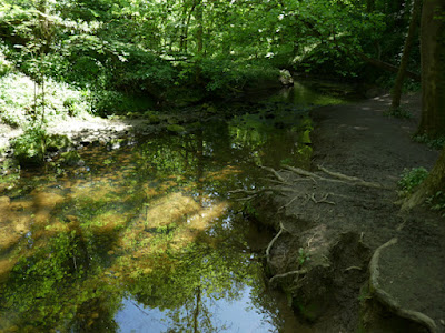 |
An eroded stream bank
|
Crossing the bridge and continuing along the path under the railway line, the brook flows through a deep and narrow channel that has been cut into the bedrock and soon disappeared from view as we ascended the path.
 |
Reef limestone
|
Carrying on past more heavily overgrown slipped blocks, we eventually came to another example of a byozoan reef, where its gnarled formless appearance contrasts with the well bedded limestone that we had just seen and also with the massive limestone a little bit further along - the last rock outcrop that we saw on our way back to the car park.
 |
Well bedded massive limestone
|


No comments:
Post a Comment