 |
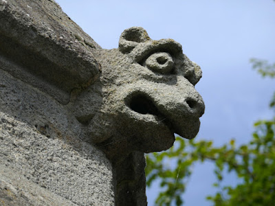
| A grotesque on the Peel Monument |
Since arriving on the No. 44 bus in Coal Aston, it had taken taken just 2 hours to photograph its listed buildings and then walk to Dronfield, where I photographed another 6 listed buildings and had a look at some of its geology on Mill Lane and Chesterfield Road.
Starting at Lea Road Bridge on the last leg of my walk, I set off along Lea Road and stopped very briefly at The Forge shopping centre, which comprises converted buildings that formed part of a forge that was last worked by W.H. Butler and Sons from 1922 to 1996, but has buildings on the site that can be dated back to 1527.
The first of the remaining 9 buildings on my British Listed Buildings Photo Challenge was the Grade II Listed Grade House, which dates back to the late C17, with C19 and C20 alterations and additions. As with the buildings in Chesterfield Road, I could only glimpse Vale House over the boundary wall and carried on past a Methodist chapel, which is now the Core Community Church.
Next to this is Grade II Listed The Manse (c.1800) and a little further along the road is another house with a similar design and of a similar age, which was occupied by the Royal Bank of Scotland before being converted into the Bank House Apartments.
Winding my way up Church Street, the partially rendered C17 Green Dragon public house was my next stop, but there isn’t much of interest for this Language of Stone Blog and I went to have another look at the Church of St. John the Baptist, before continuing up Church Street.
Continuing past the Old Rectory (1809), which I am surprised is not a listed building, two pairs of early C19 gatepiers are listed for their group value in the Conservation Area, with Historic England describing them as “Ashlar sandstone square on plan, with rusticated V-jointing. The piers support voussoired segmental arches, above which is a plain ashlar flat coping”.
The adjoining Grade II Listed house (1804) - identified by Historic England as Premises Occupied by the Slinn Computer Group - and the Old Grammar School, which dates back to at least the C17, provide further examples of the locally quarried Silkstone Rock but neither of them possess great architectural merit.
 |
| Slinn Computers and the Old Grammar School |
Passing the Red House (1731) and the early C18 Old Vicarage, which are very unusual in Dronfield because they are built with brick, Church Street turns at a right angle into High Street and continues up a more gentle slope.
Looking at the 1898 Ordnance Survey map, the mediaeval street plan and burgage plots can be clearly seen, but very little remains of Wards Yard and Post Yard, with the modern buildings and car parks around the civic centre now dominating the area.
Continuing along High Street past the town hall and various shops that have no particular architectural merit, I stopped briefly to photograph the mid C17 Manor Hotel before taking a diversion to the Grade II* Listed Dronfield Hall Barn – a community venue with attractive grounds that is well worth visiting.
There was no exhibition on in the gallery, which is located on the upper floor where there is a good king post roof, so I just had quick look around the garden and took photographs of the Grade II Listed boundary wall at the back of various houses on High Street.
Returning to High Street, I could obtain a partial view of The Cottage through the gates of the adjacent Hall and continued up the road to the Peel Monument (1854), which was erected as a tribute to Sir Robert Peel, to commemorate the repeal of the Corn Laws.
On my previous visit to Dronfield, I only took a couple of photos from a distance and so I went to take a closer look at the grotesques on the monument, which is made from very coarse grained pebbly sandstone that is probably the Chatsworth Grit.
Having been unable to get a view of the last building on my Photo Challenge, Rookery Cottage, I carried on to the library to browse through quite an extensive local history section, but I didn’t have time to sit down and read any of the publications.
At the end of a thoroughly enjoyable walk, I photographed Dronfield war memorial, which is made of the veined ‘Sicilian’ variety of Italian Carrara marble before taking advantage of the Sainsbury’s supermarket on Wreakes Lane and then catching the No. 43 bus back to Sheffield.
 |
| Dronfield war memorial |


No comments:
Post a Comment