Sunday, 25 May 2025

A Geology Field Trip in South Yorkshire

 
Posh Pillar and Her Daughters on Jenkin Road

Travelling on the buses and trains, my visit to Woolley on the 10th of October proved to be my last day out in 2023 but, the following week, after I had to be collected from Treeton when several buses failed to turn up, I co-led another field trip with the Sheffield U3A Geology Group. 
 
The Ordnance Survey map of Wincobank
 
At the Sheffield Heritage Fair a couple of years earlier, I had met one of group members, Hilary, where we had both been talking to Danny Allsebrook of the Brigantes of Wincobank Hill, which gave us the idea of arranging a visit for our group to Wincobank Hill sometime in the future – to look at the effects of the Don Monocline and to visit the Iron Age hillfort. 
 
Convening at the parking space on Jenkin Road, we firstly went to have a look at The Star Crossed Queen, a star map that was installed in 2011 as part of the artwork project known as the Journey to Hidden Places. Here, Hilary provided an introduction to Queen Cartimandua and her relationship with the Romans and the earthwork known as the Roman Rig.
 
At The Star Crossed Queen
 
Returning to Jenkin Road, Hilary then talked about Posh Pillar and Her Daughters, another sculpture that is part of the Journey to Hidden Places, which consists of a column retained from a demolished historic building and farm rollers, which are made from various granites and have poems inscribed on them. 
 
Hilary at Posh Pillar and Her Daughters
 
Making our way up the track leading to the hillfort, which is surfaced with sandstone and dolerite setts, we followed the line of the southern embankment and ditch, where Hilary further explained that Wincobank Hill provides an example of a vitrified fort and outlined other aspects of its history and archaeological investigation. 
 
On the southern embankment of Wincobank Iron Age hillfort
 
Wincobank Hill forms a very prominent landmark in the form of a hogback, which can be clearly seen from the Don Valley below and, before the steep slopes became covered in trees, there would have been views across the surrounding countryide and to another Iron Age fort at Canklow Wood in Rotherham. 
 
An exposure of the Silkstone Rock on Wincobank Hill
 
Continuing south-west along the well used and in places a very eroded path, I took over from Hilary to explain the geology dominated by the Don Monocline, which affects the strata from Sheffield to Mexborough - a distance of approximately 17 km.
 
A viewpoint overlooking Sheffield
 
Thin flaggy beds of the Silkstone Rock are exposed along the path at regular intervals, which exhibit the very steep dip of the strata here – up to 30 degrees to the south-east – and are highly fractured. The ground slopes steeply either side of the path and is covered in gorse and other thick vegetation that prevents easy access, so we carried on until we reached a point where there are panoramic views of Sheffield. 
 
Following a footpath on Wincobank Hill
 
On my previous visit to Wincobank Hill, I walked all the way down to Grimesthorpe, where there is a small quarry with exposures of the Parkgate Rock; however, we didn't consider going any further and retraced our steps to a path that we had discovered on the recce, which leads to an area of Wincobank Wood that was once the site of various industries.
  
A LIDAR image of Wincobank Hill

A LIDAR map shows lines of bell pits and adits that exploited the coal and ironstone seams that occur below the Silkstone Rock, with other charcoal pits and Q-pits for making white coal. The area has been managed over the years and, in several places, Hilary pointed out various examples of coppiced trees that are associated with its industrial history. 
 
After having our lunch at Tthe Star Crossed Queen, for the afternoon session I decided to take the group to Ockley Bottom and the Thundercliffe Grange quarries, which I had explored a couple of years earlier. The Silkstone Rock also occurs in this part of Rotherham and the area around Grange Park and Kimberworth had a similar history of iron and coal mining, which dates back to the C12, when the monks from Kirkstead Abbey worked the ironstone.
 
A quarry at Thundercliffe Gange
 
With me taking the lead during the afternoon, I didn't get much opportunity to take photos but we didn't encounter any points of interest that I haven't already described before; however, when passing Thundercliffe Grange, we met one of the original co-founders of the "co-housing scheme" here, who was kind enough to take the time to tell us about its history. 
 
A detail of the joints at Thundercliife Grange quarry
 

Thursday, 22 May 2025

A Walk From Woolley to Darton

 
Woolley Edge Rock at the old Cow Carr Wood Quarry

From the time I alighted from the No. 59 bus on Barnsley Road to when I set off from Woolley to Darton, I had spent 2 hours photographing 23 listed buildings for my Photo Challenge and having a look at the exterior of St. Peter’s church and its churchyard. 
 
Planning a walk from Darton to Woolley
 
As with previous days out to Ault Hucknall, Palterton and Scarclifffe and Whitwell and Steetley, in addition to the multiple journeys on public transport, I had to factor in a walk of approximately 3.5 km from Woolley to Darton railway station, where I could catch a train back to Sheffield. 
 
The public footpaths from Woolley to Cow Carr Wood Quarry
 
Leaving the village by Back Lane, I continued until I reached Gypsy Lane and carried on up the road to the public footpath along Hawtop Lane, before taking another very poorly defined public footpath across a cultivated field. 
 
The footpath to Hawtop Lane
 
For all of this time, I was heading in a south-westerly direction up the dip slope of the Woolley Edge Rock, which underlies the entire area that I had covered in my walk to date. Being very conscious that the farmer seems to ignore the public footpath, which tends to disorientate me, I didn’t take much notice of my surroundings and I was very glad to arrive at Woolley Edge Lane.
  
A topographic map showing the dip slope of the Woolley Edge Rock

Having crossed the road, I followed the path for a short distance through a plantation and was very interested to see a few rock exposures, which I have since learned from the Building Stones Database for England map explorer is the old Cow Carr Wood Quarry. 
 
The location of the old Cow Carr Wood Quarry
 
Making my way around a mixture of thick undergrowth and felled trees, I had a quick look at an exposure of the Woolley Edge Rock, which displays well developed large scale cross-bedding and differential weathering of the less resistant beds. 
 
Cross-bedding in the Woolley Edge Rock
 
I didn’t have my Estwing hammer with me, but I was easily able to obtain a sample of coarse grained yellowish sandstone that, apart of the lack or iron banding, is essentially identical to the piece of sandstone that I obtained from a boundary wall on New Road at the start of my walk. 
 

Specimens of Woolley Edge Rock
 
Continuing through the plantation, I was presented with a panoramic view of the landscape formed by the Pennine Lower Coal Measures Formation strata to the west of the M1 motorway, with the Emley Moor transmitting station being a landmark that can seen from miles around. 
 
A panoramic view on my walk to Woolley Colliery
 
Looking at the geological map, the areas of made and infilled ground on the escarpment show that the area was worked extensively for its coal, firstly on a small scale by using adits, but I didn’t see any obvious signs of these in the landscape.
 
Areas of coal mining shown on the geological map
 
Following the path down to Woolley Colliery, a village that is named after the former colliery, which opened in 1854 and closed in 1987, I passed two rows of red brick terraced houses, which were originally built to house the miners. These and a small replica of the headstock are the only reminder of its existence, with the buildings being demolished in 1993 and the Woolley Grange housing estate built on the site.
 
A replica of the headstock at Woolley Colliery
 
Arriving on the outskirts of Darton, having missed my hourly train back to Sheffield and having to pass the time, I carried on into the village to have another quick look at the stonework of All Saints church, which I had visited a year earlier.
 
All Saints church in Darton
 
At the time, I thought that the coarse grained sandstone used in its construction is very likely to be the Woolley Edge Rock and, after having had a good look at this sandstone in the historic buildings, boundary walls and a quarry in Woolley, I now feel quite sure of this.
 
Sandstone in the tower of All Saints church
 
I didn’t think to compare the samples that I had obtained with the masonry of the tower, where the sandstone is best exposed, but the colours and textures seemed to match those that I had seen earlier. Returning to the railway station, I stopped very briefly to look at the terraced houses that comprise No. 20-26 Church Street, where the finer grained iron stained sandstone looks more typical of the Coal Measures sandstones.
 
Nos. 20-26 Church Street


Wednesday, 21 May 2025

St. Peter's Churchyard in Woolley

 
A detail of the grave slab of William Sykes (d.1742)

Except for my better appreciation of the physical characteristics of the Woolley Edge Rock, my visit to St. Peter’s church proved to be a bit of a disappointment – because I was unable to have a look at its interior, which the Corpus of Romanesque Sculpture of Britain and Ireland records as containing a resited tympanum and a shaft.
 
A squeeze stile

Shrugging my shoulders, I then went to find the Grade II Listed cross base and the grave slabs and chest tombs in the graveyard, which I had first entered through a squeeze stile – a structure that I had never encountered before and had to talk with a dog walking resident, before using it. 
 
The cross base
 
On my travels I have seen very many of the cross bases like this, which Historic England (HE) describes as probably being mediaeval, but this square section stump embedded in a round base does not have any interesting features and I only took a single record photograph. 
 
The tombs of George Wildsmith and George Stringer
 
The pair of raised grave slabs are memorials to George Wildsmith (d.1724) and George Stringer (d.1723). Both have channelled borders and finely-carved semicircular-arched heads, with the Wildsmith memorial having winged-head spandrels and a carved heart motif, although the details are not easy to see because of the dense growth of lichens.
 
The tombs of Susanna and Anne Fretwell

Another pair of raised slabs commemorate the wives of Robert Fretwell, Susanna (d.1707) and Anne (d.1714). Again the detailing of these is obscured by lichens, but the slab to the right has a carved circular motif with floral border surmounted by trumpeting angel.
 
The chest tombs with pitched roofs
 
A pair of chest-tombs that caught the attention of Pevsner are described by him as “two shrine-like tomb-chests with pitched roofs. What date can they be?”, to which HE adds that they are of uncertain date and possibly pre-Norman.
 
A close up view of a chest tomb with a pitched roof

The criteria for listing table tombs and grave slabs does take into account the architectural style, sculpted designs and inscriptions; however, very often it seems that they are primarily listed if the person commemorated has local significance.
 
Various unlisted chest tombs
 
This would explain the listing of memorials that appear to my eye to have very little merit from a design point of view or other features that set them apart and, on the other hand, those that I think are noteworthy but are not listed – such as the grave slab of another George Stringer (d.1826). 
 
A detail of the grave slab of George Stringer
 
Continuing my quick wander around the churchyard, I kept my eyes open for more examples of fine calligraphy and letter cutting on C18 grave slabs, including that of George Prince of Woolley (d.1764), which has strange looking winged creatures that look more like modern depictions of supposed aliens than angels. 
 
A detail of the grave slab of George Prince

Another interesting C18 memorial is the footstone of the grave of Henry Broomhead (d.1733), a feature that I first recall seeing amongst the many Grade II Listed gravestones at All Saint’s churchyard in Darton and then at All Saint’s churchyard in Wingerworth. 
 
The footstone of Henry Broomhead
 
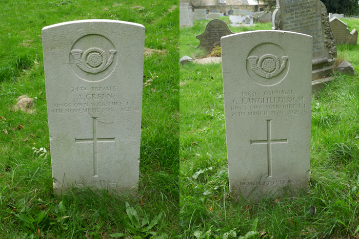
I briefly finished my very brief walk around St. Peter’s churchyard by taking a couple of record photographs of the Commonwealth War Graves Commission Portland stone headstones of Private A. Green and Corporal C. Langfield, who both served in the King’s Own Yorkshire Light Infantry.
 
The headstones of Private A. Green and Corporal C. Langfield

Monday, 19 May 2025

St. Peter's Church in Woolley

 
A view of St. Peter's church from the south-east

Starting my day out to Woolley by alighting from the No. 59 bus at the Barnsley Road/George Lane stop at approximately 11:54 am, after photographing 19 listed buildings and other structures as part of a British Listed Buildings Photo Challenge, it took me exactly an hour to walk to the Grade I Listed St. Peter’s church.
 
The tower
 
Having looked online and found that its Google Map listing showed that it would be open, in the absence of such information on the church or related websites, I was very disappointed to discover that it was actually closed.
 
The interior of the porch

Looking at the notices in the porch, I had hoped to find details of a keyholder but found no information there and, having seen a window open and a car parked outside, I went to the vicarage next door where, much to my great surprise, I was greeted by the Bishop of Beverley.
 
Woolley Edge Rock in the porch

Having explained that I had made a special effort to visit the church, which involved travel by two buses a train, I thought that he might have tried calling Reverend Kevin Greaves, who doesn’t actually live in the village, to ask for the whereabouts of a key, but he didn’t seem at all interested and so I just returned to the church to have another look at the interior of the porch.

The south door
 
During previous visits to Wakefield Cathedral and the Chantry Chapel of St. Mary in Wakefield and St. Helen’s church and Sandal Castle in Sandal Magna, I noticed that the coarse grained sandstone had a very distinctive striped appearance, caused by differentially weathered iron rich beds with a purplish colour.

A detail of the surround to the south door
 
In this area, the geological memoir for Wakefield (1940) records that the Woolley Edge Rock was a very important building stone in the region, with a reference to its use for the restoration of the cathedral. As a 'geological detective', I have had to deduce that it was sandstone from this rock formation that I had seen in these buildings – based on my own observations of its physical characteristics, compared to very many others that I had by now seen on my travels.
 
A detail of striping in the Woolley Edge Rock

Having had a good look at the Woolley Edge Rock in the porch, I had a quick walk around the exterior of the church. Pevsner’s description of the exterior is limited to “Perp throughout” and Peter Ryder, in Medieval Churches of West Yorkshire, says that the only architectural features to survive from earlier periods are all reset in later walls. The rest is the result of the late C15 and early C16 remodelling, carried out in various phases and a restoration c.1870 by Ewan Christian.
 
A detail of the south wall of the porch

The masonry to the outer south face of the porch displays thin planar beds and more massive sandstone with cross-bedding, which are both deeply scoured in places and, as seen elsewhere in the Woolley Edge Rock, the thin iron rich beds are differentially weathered.
 
Millennium sculptures by Charles Gurrey
 
I was very surprised to see two interesting pieces of modern sculpture designed by Charles Gurrey on the porch, one an upside down cross and the other a relief sculpture set into a niche, which depicts three fish. Part of a Millennium project in 2000, these are both symbols of Saint Peter, who was crucified upside down and known as the fisher of men.
 
A crocketted pinnacle on the chancel
 
For a C15 church, typically flamboyant Perpendicular Gothic style elements are few and far between, with a castellated parapet, crocketted pinnacles and modest gargoyles to the tower. On the east wall of the chancel, quite unusually, there is a pair of crocketted pinnacles that have a very large diameter compared to their height.

Views of the south and north elevations
 
Without getting close to the masonry, I took a set of general record photographs of the south and north elevations, but I did notice that a section of walling below the chancel window that has been restored using precisely squared blocks with a tooled finish. Although lacking the yellow/orange colouration of the original stonework, these show thin purplish stripes, which is similar to that seen in the historic buildings mentioned above.

Restored masonry in the east wall of the chancel