Friday 30 August 2024

The Geology Along Totley Brook

 
A small waterfall

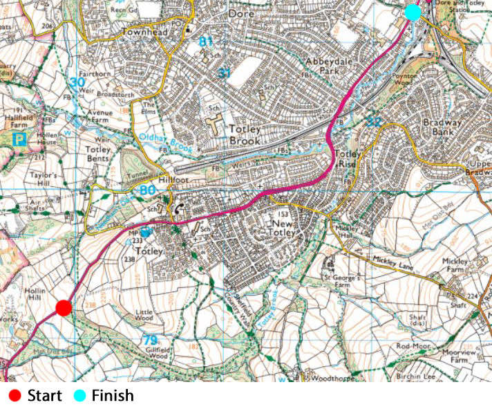
When preparing the 2023 field trip itinerary for the Sheffield U3A Geology Group, one of the members suggested that we could have a walk around Totley, where she lives, but the consensus was that there probably wouldn’t be enough to fill the day, which usually starts at 10:30 and finishes by 15:30. 
 
The Ordnance Survey map of Totley
 
I had only briefly visited the area around All Saints church and, having plotted a route using the Ordnance Survey map, a few days after my walk from Fulwood Road to Sheffield General Cemetery, I spent a couple of hours exploring Totley Brook. 
 
A dry stone wall built with Greenmoor Rock

Alighting from the No. 97 bus from Sheffield at its terminus on Baslow Road, where I immediate found the entrance to Gillfield Wood and followed the public footpath, which runs along the northern slope of quite a substantial valley, until I reached a dry stone wall. 
 
The geological map shows that Totley Brook cuts through the Greenmoor Rock, which in this part of Sheffield is split by thick partings of mudstone or siltstone. I didn’t get near to inspect it very closely, but its thin bedding and colour are quite characteristic features of this rock formation. 
 
Flaggy Greenmoor Rock in the streambed
 
Eventually I caught sight of the brook and, when the path dropped down to a lower level, I could see blocks of flaggy sandstone littering the streambed. I noted plenty of unstratified head but there was no sign of outcrops until I encountered a couple of meanders, where small outcrops of flaggy sandstone are exposed in the bank, but I could not get access to them. 
 
An exposure of Greenmoor Rock in a meander of the brook
 
With the brook continually meandering and with no GPS device or obvious landmarks to pinpoint my exact location along the brook, I continued to see flaggy sandstone blocks littering the streambed, which I think must be Greenmoor Rock but didn’t note any further outcrops.
 
Another meander littered with slabs of Greenmoor Rock
 
The first recognisable landmark was a signpost at the junction of the public footpaths to Mickley Lane and Woodthorpe Hall, which I was able to identify on the Building Stones Database for England map explorer. This shows that I had by now crossed a fault with a downthrow to the east and that, for the rest of my walk, Totley Brook flowed across the Grenoside Sandstone or the associated Pennine Lower Coal Measures Formation PLCMF) strata. 
 
The Building Stones Database for England map explorer
 
Continuing along the path, in the stream banks I could see mudstone that is weathered to yellow/orange clay, with a thick covering of head and sometimes alluvium, which had been deposited in times of flood and, wherever possible, I got down into the streambed to investigate them further. 
 
Views of the stream banks

As I headed further downstream, exposures of thinly bedded sandstone, siltstone and mudstone are more frequently encountered in the streambed and stream banks. At one place that I can’t precisely locate, a thinly bedded sandstone forms quite a substantial outcrop in the streambed, with forms distinct riffles. 
 
An outcrop of rock in the streambed
 
Immediately downstream, slabs of a slightly more massive fine grained sandstone project from the stream, which appear to be dipping to the south-east. Before I had crossed the fault, the geological map shows a dip of 20 degrees to the north. 
 
Steeply dipping slabs of sandstone
 
On the Friends of Gillfield Wood website, a geological map produced by Bob Warburton for his thesis shows that, before arriving at the previously described fault, several measurements show that the strata dip to the north but beyond this the dip is quite variable, with measured dips to the north-east and south-east reflecting the proximity of the Dronfield Syncline. 
 

A geological map of Gillfield Wood © Bob Warburton


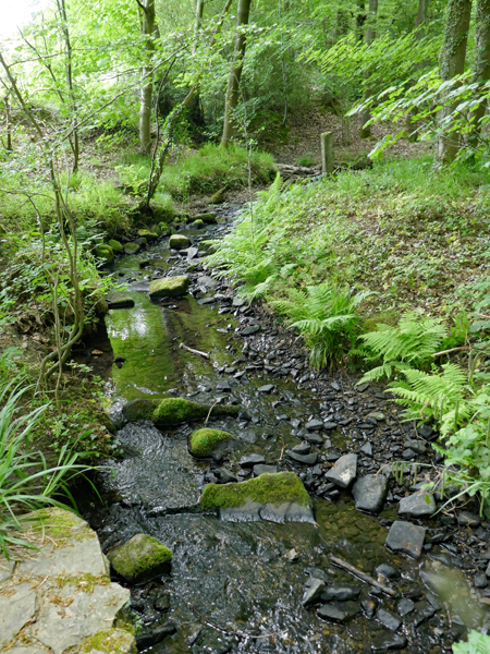
A little further downstream, the strata changes again to a much more thinly bedded sandstone, with softer beds being differentially weathered. Along this stretch of the brook, where the sandstone is slightly more massive and the beds are thicker, there are small waterfalls. 
 
Thinly bedded fine grained sandstone in the streambed
 
From this point onwards, the brook continues to meander across PLCMF strata and the Grenoside Sandstone, in a much wider and shallower valley, with mudstone and head exposed in its banks. Reaching the path to Mickley Lane and crossing the bridge over the brook, there is an exposure of what is probably Grenoside sandstone, but I couldn’t get close to it. 
 
A view from the bridge on the path to Mickley Lane

On my walk, although I had seen plenty of Greenmoor Rock as small slabs in the streambed and occasionally in the stream bank, I did not obtain any samples and those that I collected were all from exposures where the PLCMF or Grenoside Sandstone form the underlying rock. 
 
Specimens collected during the walk
 
They vary from grey to buff in colour with varying degrees of iron content and staining, are fine to very fine grained in texture and mostly thinly bedded. The specimen that I collected from near to the waterfall is grey in colour, very fine grained and  micaceous - a characteristic of the Grenoside Sandstone - but none of the specimens look much like the rock that I have seen where used as a building stone in the type locality of Grenoside. 
 
Very fine grained grey micaceous sandstone
 

Wednesday 28 August 2024

Fulwood Road & the General Cemetery

 
The Bulls Head public house in Ranmoor

After having a quick look at Cairns Chambers and Steel City House, which added to my knowledge of the historic architecture of Sheffield, I caught the No. 120 bus from West Street to Ranmoor – where I met Jane Bartholomew of the Fulwood History Group. She had asked me if I could provide some background information on the geology and building stones, for a project on the history of Fulwood Road that she was preparing. 
 
The walk along Fulwood Road
 
We started our very short walk at the Bulls Head public house, which I hadn’t investigated when preparing my illustrated talk for the Ranmoor Society. It is built with very coarse grained probably sandstone, which I explained was Chatsworth Grit from one of the quarries in the Rivelin Valley. 
 
Pebbly Chatsworth Grit at the Bulls Head public house
 
For the next hour and a half, we continued up Fulwood Road and, taking various diversions, stopped to look at road setts, kerbs, paving, boundary walling and their coping stones and gatepiers, which are made from Chatsworth Grit and other sandstones that have been quarried locally from the Rough Rock and the Crawshaw Sandstone. 
 
Along this stretch of Fulwood Road, Land Societies played a great part in the development of Ranmoor and a feature of the area is the development of large, well planted gardens that are generally in proportion to the size of the substantial detached and semi-detached villas, which were built for the middle classes. 
 
In very many of these gardens, massive boulders of sandstone cleared from the building plots have been used for landscaping. At the end of the last ice age, by the process of solifluction, blocks of stone that had become detached from the bedrock on the high ground to the north moved downslope and littered the land – as seen in many of the undeveloped areas on the upland outskirts of Sheffield. 
 
Large boulders of sandstone used for landscaping
 
When we reached Nether Green Junior School, I was interested to see that work was being undertaken to the building during the school summer holiday and I popped into the site office to ask the site manager about the work that was being carried out. 
 
The Birch site office
 
Although the main work was to the roof and general maintenance, I explained that this school was known to be built with Crawshaw Sandstone from Bole Hill in Crookes and that, as a geologist, I would be interested in obtaining a piece if any was removed. I took his details and said that I would keep in touch but, with other things keeping me busy over the summer, nothing came of this. 
 
The Sheffield architectural guide
 
Leaving Jane at this point, with a promise to turn up to meet other members of the Fulwood History Group the Fulwood Fete in a couple of weeks, I made my way down to Endcliffe Park, where I purchased a copy of the Pevsner Architectural Guide for Sheffield from Next Chapter Books. 
 
Igneous rocks from Sweden, Norway and Scotland
 
I could easily have caught a bus back to Sheffield city centre from here, but I instead decided to take another look at Sheffield General Cemetery, which I had last visited in December 2021 – starting with the large blocks of Swedish Imperial Red Granite, Norwegian larvikite and Rubislaw granite from Aberdeen in Scotland. 
 
The base of the catacombs at Sheffield General cemetery
 
In the interim, £3.8 million had been spent on its refurbishment, was very near to completion, with a substantial amount of work being undertaken to the catacombs, which had fallen into a state of considerable disrepair. I didn’t examine the new stonework in any detail, but it is probably either Crosland Hill stone from Huddersfield or Stoke Hall stone from Grindleford – both of which have been used extensively in Sheffield. 
 
Restoration of the balustrade
 
My friend Catherine from the Sheffield U3A Geology Group had volunteered to organise the  September 2023 field trip and I was particularly interested to see how how the Geological Stone Spiral looked. It was installed back in 2004 and, by the time of my last visit, the fresh surfaces had become very obscured by a combination of weathering, algal growth and dirt. 
 
The Geological Stone Spiral
 
This made it difficult to distinguish the various rocks and, with such a large budget for the project, I had expected these to have been cleaned with a high pressure washer; however, I was very surprised to see that they were in the same condition and soil had been piled up around the stones, from which weeds were growing.
 
The Geological Stone Spiral

Sunday 25 August 2024

Historic Architecture in Sheffield - Part 6

 
Cairns Chambers on Church Street

For my first trip of June 2023, following my visit to Burngreave to look at its war graves and geology, I had arranged to meet Jane Bartholomew, a member of the fledgling Fulwood History Group, who had become aware of my recent talk to the Ranmoor Society and had asked me if I could help with her research on the history of Fulwood Road. 
 
A plaque on the Cutlers' Hall
 
Arriving in Sheffield on the bus from Treeton, I had time on my side before catching the bus to Ranmoor and took a walk along Church Street to West Street. Before I joined in with the British Listed Buildings Photo Challenge, most of the most interesting listed buildings in Sheffield city centre had already been photographed and, except when organising field trips for the Sheffield U3A Geology Group, I had not spent any time looking closely at any of them. 
 
A plaque on the former HSBC bank
 
Having discovered that Stoke Hall stone from Grindleford has been used in the Cutlers’ Hall (1832) and three banks in the vicinity – which may include the former Royal Bank of Scotland (1867) and HSBC (1838) banks on either side – they deserve a closer look but, on this occasion, I just photographed the bronze plaques on these and continued along Church Street to the Grade II Listed Cairns Chambers (1895). 
 
Cairns Chambers
 
I had passed by this building many times and, except for noting the statue of a former Lord High Chancellor, Earl Hugh Cairns, which I have since learned was carved by Frank Tory, I remember it mostly for never having seen the building occupied.
 
The statue of Earl Hugh Cairns

Looking up to the various dressings and intricately carved panels, which I think may actually be Jurassic oolitic limestone rather than Millstone Grit from Derbyshire or West Yorkshire – and therefore requires a closer examination - the grotesques are very similar to those seen just down the road at Parade Chambers (1884), which suggests that these were also carved by Frank Tory. 
 
Various stone dressings at Cairns Chambers
 
Continuing to West Street, I briefly stopped to take a couple of photos of the Grade II Listed Steel City House (1927), a former telephone exchange that incorporated a post office, shops and a bank, but is now used as offices. 
 
A view of Steel City House from Church Street

It was designed by H.T. Rees for H.M. Office of Works in the Classical Revival style, with Portland stone cladding applied to a steel frame. It is another fine building that I have passed by numerous times, but it does have some very interesting details and it deserves further investigation.
 
The west end of Steel City House
 

Thursday 22 August 2024

Geology & Architecture in Burngreave

 
Samples of Parkgate Rock from Kilton Hill (21 mm diameter coin)

My last day out in May 2023, with the principal aim to photograph the Commonwealth War Grave Commission headstones in Burngreave Cemetery, had taken hours and, before leaving by the Melrose Road entrance, I stopped briefly to take a photo of the twin chapels (1861) that were designed by Flockton and Lee.
 
The twin chapels at Burngreave Cemetery
 
Continuing along Melrose Road until I reached the Roman Catholic Church of St. Catherine of Alexandria (1925), where I wanted to see if I could get access to an old quarry face that I had noticed when last passing this church. 
 
Melrose Road on the 1892 Ordnance Survey map
 
On the 1855 edition of the Ordnance Survey map, the area formed part of Burngreave Wood and a quarry wasn't shown here but, on the 1892 edition, it was marked as an old quarry. The nearby Victorian houses of this period are built with brick and not stone, except for the boundary walls, and the quarry could therefore have been opened to supply stone for these. 
 
The old quarry behind the Church of St. Catherine of Alexandria

I couldn’t get access to the quarry face, which is now mostly covered by a retaining wall but I did manage to get just a glimpse of it through the gate and, when returning home, I looked at the geology map and discovered that this is the Silkstone Rock - a formation that I had seen in the cuttings at Sheffield Midland railway station and at Wincobank Hill. 
 
The geology around Burngreave
 
During previous visits to this part of Sheffield, which had been part of a longer walk, I had photographed Christ Church and the Pye Bank School as part of the British Listed Buildings Photo Challenge, but had not yet seen the Seventh Day Adventist Church and set off up Rock Street, where the houses on its west side were built between 1850 and 1892. 
 
Walling and a gatepost on Rock Street
 
The garden walls and gateposts, which in places are quite substantial, are built with a sandstone that is very rich in iron, with well developed Liesegang rings and concentrations of ironstone – a characteristic of the Silkstone Rock, Parkgate Rock and associated minor sandstones. 
 
The Seventh Day Adventist Church on Andover Street
 
Continuing to Nottingham Street and Andover Street, I stopped to take a few general record photos of the Seventh Day Adventist Church (1865) by William Hill of Leeds. From these, I can see that the sandstone does not have a very high iron contact and has plane bedding, which is one of the distinctive characteristics of the Crawshaw Sandstone from Bole Hills. 
 
The south transept
 
These quarries supplied the sandstone that was used to build the vast majority of the Sheffield Board Schools and various Victorian churches and, according to Hunts Mineral Statistics, were by a long way the largest supplier of sandstone in Sheffield. 
 
The boundary wall and a gatepost

I didn’t stop to examine them closely, but the gateposts are made of a coarse grained massive sandstone that is probably from the Chatsworth Grit in the Rivelin Valley, but the upper part of the boundary wall is actually artificial stone, which has a very coarse aggregate. 
 
Weathered sandstone in a boundary wall on Kilton Hill
 
Making my way down Andover Street and looking down Kilton Hill, I noticed the high boundary wall next to the electricity sub-station and, going to investigate, could see that the coursed rubble siltstone is very soft and that most of the blocks have been very rounded by weathering. 
 
An outcrop of Parkgate Rock on Kilton Hill
 
On the opposite side of the road, behind the shrubs and thick undergrowth, I was interested to see small outcrops of quite flaggy sandstone in the upper part of the overgrown bank. Although I didn’t come out with my Estwing hammer, I was determined to obtain a specimen and scrambled up the bank to collect a loose piece to add to my rock collection. 
 
Flaggy sandstone in the Parkgate Rock

The 1855 Ordnance Survey map shows a couple of quarries in the Parkgate Rock on Burngreave Road but, when the 1892 edition was published, it shows that this exposure is part of the cutting that was formed when Kilton Hill was laid out in this rapidly growing suburb. 
 
Quarries shown on Ordnance Survey maps
 
A little further down the hill, I then encountered part of the southern face of the western quarry and, having asked permission from the proprietor of the adjoining mechanic business, took a few photos of the quarry face and obtained another specimen of Parkgate Rock. 
 
Views of the old quarry on Kilton Hill
 
The quarry is occupied by several automotive businesses and a former petrol station that is now used as a hand car wash and there are no obvious signs of any other quarry faces; however, this small section shows that the strata dips to the south-east and follows the strike of the Don Monocline, which the British Geological Survey map marks as being 12 degrees here. 
 
A medium grained specimen of Parkgate Rock
 
Of the two samples that I collected, the one that I collected from the Kilton Hill cutting is distinctly grey, medium grained and well bedded, which is very different to the fine to very fine grained sandstone, with the development of iron banding and small flattened clay ironstone pellets, which I collected from a lower level in the old quarry face.
 
Fine grained Parkgate Rock with clay ironstone pellets