Leaving the lodge to the Towers, I crossed to the other side of Sandygate Road and immediately came across further examples of the Chatsworth Grit in the kerbstones, large paving setts and a boundary wall, which is weathered to a uniformly grey colour, with some iron staining.
I didn’t stop to closely examine any of them, but I didn’t notice any obvious pebbly beds like I had seen at the entrance to the Towers. Most of the Chatsworth Grit that I had seen to date was a very massive sandstone, but a lot of the coarse grained walling stone here is planar bedded, with larger blocks used for the copings.
Passing the entrance to Sandygate Lodge, I was interested to see that large blocks of sandstone have been used for landscaping in the front garden. During a previous walk around Ranmoor and along Fulwood Road, I had seen many large houses with landscaping like this, with the scattered large stones being cleared from the land as they were being built.
Crossing over the road again, I was intrigued by a private garden and pond that is set in what seems to be a landscaped old quarry. On the 1894 Ordnance Survey map, a quarry like excavation is clearly marked to the east of what is now Sandygate Lane, but it is not named as a quarry.
Stopping very briefly at the private Claremont Hospital, I was interested to see that the main house, lodge and various outbuildings are built with a Coal Measures sandstone and not Chatsworth Grit, but I only took a few quick record photos.
Looking at the detail of the walling to the lodge, the sandstone is medium grained, has planar bedding and iron staining is sometimes developed as Liesegang rings. A moderately sized quarry in the Crawshaw Sandstone operated at nearby Ranmoor, which supplied the stone to build the older parts of the village and it is possible that it is the source for the stone here.
Having had a good wander around many of the western suburbs of Sheffield, which grew rapidly in the second half of the C19, I have seen very many different sandstones used in houses of all sizes, along with their boundary walls, gateposts and the pavements and roads that surround them – but there is so little evidence remaining of the quarries themselves.
My next stop was the Grade II Listed Holly Mount, which I photographed at a distance and could not really see the stone very well. Continuing my walk along the north side of Sandygate Lane, I encountered various ornate caps to gatepiers and walls and further sections of walling, which contain blocks of pebbly Chatsworth Grit and the typically grey sandstone has marked iron staining in places.
Beyond Sandygate Park, the roadway opens up with a wide grassy verge that separates the road from the footpath, which much to my surprise contains several small outcrops of Chatsworth Grit that poke out from an area of slightly raised ground.
The Chatsworth Grit used for the boundary walls continued to throw up surprises, with further examples of pebbly beds, where milky quartz is clearly visible. Although I have a few samples of Chatsworth Grit in my rock collection, none of them are pebbly in nature and so I couldn’t resist taking home a small piece that I found on the footpath, which must have become dislodged from the adjoining wall.
Passing the clubhouse at the Hallamshire Golf Club, on Redmires Road, which is a continuation of Sandygate Road, I went to investigate the public footpath that crosses the golf course to the Rivelin Valley and was interested to find that it passes a former small quarry that has been excavated into the edge of the Chatsworth Grit.
Although I had my Estwing hammer with me, there was nowhere where I could easily obtain a sample and some of the remaining faces are obscured by trees and quite inaccessible, so I just took a few record photos and carried on along Redmires Road.
The 1855 Ordnance Survey map shows that there was previously another larger quarry a short distance further down the road, which was known as the Barncliffe Quarry but is marked as disused on the 1947 edition. This is wholly within the grounds of the golf club, but there are tantalising glimpses of thick clumps of gorse just beyond the boundary wall, which are probably hiding some old quarry ledges and faces.
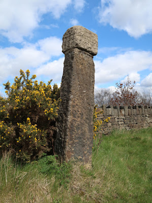
I finished this leg of my walk by taking a few photographs of the Barncliff Stoop, an old waymarker that is considered by Historic England to be probably C14 and erected to mark the line of an "ancient packhorse highway" - the Long Causeway - but the square capstone has a barely legible date that looks to be from the C18.


No comments:
Post a Comment