 |
| Stone tile roofs at Grange Farmhouse |
Having a good look at various examples of the use of the Chatsworth Grit, at the lodge to the Towers and along Sandygate Lane and Redmires Road, I set off to explore the residential suburbs of Carsick Hill and Stumperlowe – another part of Sheffield that I had never visited before.
 |
| A structure along the route of the Redmires conduit |
Crossing the road from the Barncliff Stoop, I headed along Hallam Grange Road, which is dominated by inter-war houses, before finding a public footpath that runs along the route of the Redmires conduit, which was built to carry clean water to Barker's Pool following the devastating cholera epidemic of 1832.
 |
| A large Arts and Crafts style house |
Arriving at Tom Lane, I was immediately struck by a very large Arts and Crafts style detached house, which has been built on one of the plots of land that was offered for sale by the Carsick Hill Society, after it was formed in 1876. Seven Land Societies were formed around Ranmoor but, although this part of Sheffield is very desirable, the plots didn't sell until the C20 because the area wasn't yet well served by public transport.
 |
| No. 109 Tom Lane |
The Grade II Listed early C19 house at No. 109 Tom Lane is very probably built with Chatsworth Grit, as are many of the various boundary walls that I saw when having a quick wander around the area; however, the underlying bedrock is the Rough Rock here, which forms an escarpment below which outcrop softer Pennine Lower Coal Measures Formation (PLCMF) rocks.
 |
| A view from Tom Lane towards Greystones |
Turning down Belgrave Drive, the Edwardian Westgarth is built out of quite thinly bedded masonry, with a high proportion of dark rusty brown blocks, which I had seen many examples of during my investigation of Fulwood the previous summer and I thought was the Rough Rock.
 |
| Westgarth |
I could only see the house at a distance, from the entrance, but it certainly looks quite different to the Chatsworth Grit that I had so far encountered on my walk, which is again used for the large round gatepiers. Continuing along Belgrave Drive, the public footpath runs along a snicket, where the boundary walls are built out of a mixture of massive and flaggy sandstone.
 |
| The boundary wall along the snicket at Belgrave Drive |
Looking over the boundary wall, I got glimpses of the north elevation of Grange Farmhouse, which Historic England describes as “early C17 and early C18, remodelled c1929, with addition to left c1965, in sympathetic style”. From the few quick snaps that I took from over the high boundary wall, I can’t see enough to tentatively determine its provenance, but the dark rusty brown colouration again suggests that this may again be Rough Rock and not Chatsworth Grit.
 |
| Views of Grange Farmhouse |
The Rough Rock was best known around Sheffield for its stone roof tiles, which were quarried in a few places on the west side of Sheffield, but the quarries did also produce building stone. Walking round to its entrance on Stumperlowe Hall Road, I was interested to see that the roof to the south elevation uses these extensively, with some fine details around the gables.
 |
| Various stone tile roofs at Grange Farmhouse |
Adjacent to Grange Farmhouse is the early C17 The Barn, a complex of buildings that was converted and altered in the late C20 and is built with the same materials. I took a few photographs of the various elevations that I could see from the driveway and when continuing with my walk down Stumperlowe Hall Road.
 |
| The Barn |
This is a very affluent part of Sheffield and, when taking a few record photographs of the Grade II Listed Stumperlowe Cottage and Barn, one of the residents who had been walking along the road was curious to know what I was doing. I explained that this was part of my preparation for an illustrated talk to the Ranmoor Society, on the subject of the local geology and architecture, which I would be giving later in the year.
 |
| Stumperlowe Cottage and Barn |
Continuing along Stumperlowe Hall Road, I encountered a block of unlisted buildings that I assume to be mainly agricultural, which has been built in various phases and styles and has some interesting window details at its southern end.
 |
| Various old buildings on Stumperlowe Hall Road |
Next to these are the late C17 Stumperlowe Grange and Stumperlowe House, which was originally one house. I could only see the roadside elevation of this imposing building, but it is built with PLCMF sandstone, with quoins that look like the medium/coarse grained Kinderscout Grit or Ashover Grit from Derbyshire.
 |
| Stumperlowe Grange and Stumperlowe House |
I didn’t stop to examine the stones closely but, looking at a photograph of the walling, it is medium grained and planar bedded and is quite similar to the sandstone that I had seen for the lodge at Claremont Hospital, while walking along Sandygate Lane earlier in the day. The old Ranmoor quarries, producing Crawshaw Sandstone, were not far away and may have been its source.
 |
| Walling stone at Stumperlowe House |
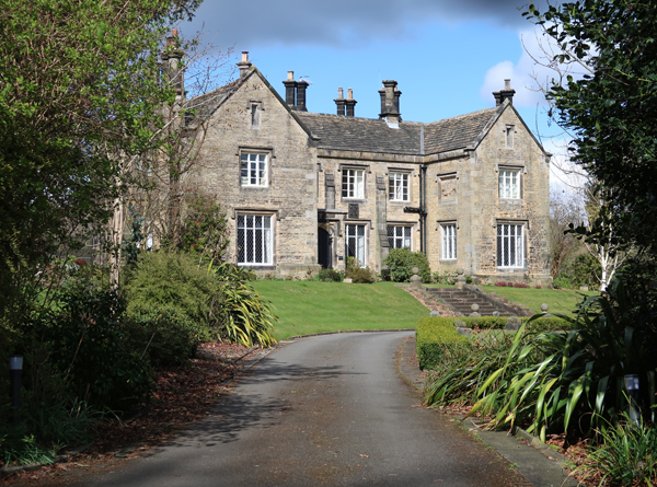
The last building on my list to photograph for the British Listed Buildings website was Stumperlowe Hall, whose original owners - the Mitchell family – had owned land in the area since the late C14. Henry Isaac Dixon (1820-1912), a co-owner of the Britannia metal manufacturing company James Dixon & Sons of Cornish Place, acquired the C17 hall in 1854 and replaced it with this substantial Tudor Revival style house.
 |
| Stumperlowe Hall |
The hall is set back from the road in a large garden, which has a back gate and main entrance gate, from which I could get glimpses of the house. When enlarging my photos, I can see some dark rusty brown blocks, which can be seen in both the Rough Rock and the Chatsworth Grit, but I think the latter has been used here.
 |
| Stumperlowe Hall |
No comments:
Post a Comment