 |
| The Coal Measures cliff |
As a geologist, the highlight of my trip to Crystal Palace Park in April 2021 was undoubtedly the ‘dinosaurs’ – a set of palaeontological reconstructions by Benjamin Waterhouse Hawkins – but these were just part of a much bigger project devised by Joseph Paxton and the consultant geologist David Thomas Ansted, with their construction by James Campbell, which were originally known as the 'Geological Illustrations'.

To provide an appropriate setting for the animal sculptures, the landscaping was designed to represent the geology of Britain from the Primary (Precambrian-Lower Palaeozoic), to the Secondary (Upper Palaeozoic-Upper Cretaceous) and Tertiary (Cenozoic–Quaternary) eras, with rocks matching the age of the animals being brought in from appropriate sources or, in the case of the plinth of the Megaloceros, constructed using Thames Gravel.
 |
| Megaloceros standing on a plinth made with Thames Gravel |
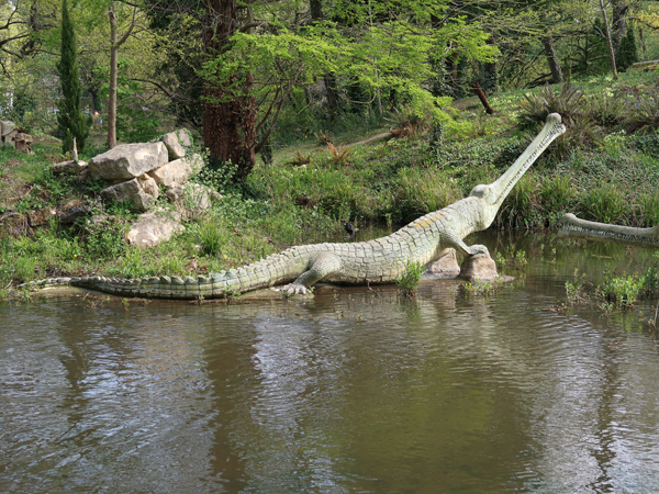
Walking along the path from the Tertiary Island to the Secondary Island, I have to say that I was too busy trying to take a good photograph of the Megalosaurus and I only noticed the small cliff of Portland limestone in the background, when reviewing my high resolution images for this Language of Stone Blog a year later.
 |
| A small cliff of Portland limestone behind Megalosaurus |
Due to their obscured location, I had missed entirely the Chalk upon which the Pterosaurs have been placed but, arriving at the Paxton Bridge, large quantities of the Upper Carboniferous Rough Rock sandstone has been used to form a ‘riverbed’ and various extensive reproduced rock exposures that look quite authentic.
 |
| Landscaping with Rough Rock |
From the early 1840s onwards, geology was included in formally laid out urban parks as a feature of urban planning and Joseph Paxton had already demonstrated his ability to create large landscaping features at Chatsworth House - the Rock Garden and the Strid. The large blocks of Rough Rock were quarried from Bramhope in West Yorkshire, which would have been expensive, but the artificial stone Pulhamite was used for many large landscaping projects from this time onwards, at a much reduced cost.
 |
| A view of the Coal Measures cliff |
Continuing along the path, I was very surprised to encounter the Coal Measures clff - a complex feature that includes a horst and associated faults - which has coal cut in blocks and accurately relates to the sandstones and ironstones that are typical of the Clay Cross colliery from which the materials were obtained.
 |
| The Coal Measures cliff |
The idea of this part was to illustrate the natural resources that had enabled the industrial revolution to take place. Apparently, at least one of the directors of the Crystal Palace Company was also the director of the Clay Cross colliery in Derbyshire, including the mining engineer James Campbell, who was responsible for the construction of the original cliff of Mountain Limestone (Carboniferous Limestone).
 |
| The Mountain Limestone cliff |
From the opposite side of the path, although I needed the zoom lens on my camera to see them, the four footed Iguanodon is standing on a plinth that is built with Wealden sandstone and a small ‘cliff’ of Jurassic oolitic limestone from the Cotswolds is set on the edge of the Secondary Island, behind a Teleosaurus.
 |
| Jurassic oolitic limestone behind a Teleosaurus |
Further along the path, the gated and inaccessible entrance to a three-quarters scale lead mine can be seen in the Mountain Limestone. The feature, which included pipe veins, rake veins, and stalactites, was completely destroyed in the 1960s during remodelling of the waterfall; however, enough remained to be able to carry out archaeological investigations and subsequent rebuilding (2001-2003) using 110 tonnes of Carboniferous Limestone that was obtained from Once-a-Week quarry, near to the original source in Derbyshire.
 |
| The entrance to the reconstructed lead mine |
The original feature was constructed with Devonian Old Red Sandstone beneath the Carboniferous rocks, with Triassic New Red Sandstone above, but the feature is only visible from a distance and I could not see any evidence of these.
 |
| Information on the Coal Measures cliff |
As with the ‘dinosaurs’, a well designed information panel is strategically placed on the path, which describes the rocks that are represented and provides the visitor with an introduction to geological time, stratigraphy and the means of dating rocks.
 |
| Information on geological time |
Making my further along the path beyond the Ichthyosaurs and Plesiosaurs, I could quite clearly see another curved cliff made of White Lias limestone but I saw no signs of the Triassic red sandstone that has been used in the landscaping in the area where the Labyrinthodons and Dicynodons have been placed.
 |
| A cliff of White Lias limestone |
No comments:
Post a Comment