Having spent less than an hour exploring some of the historic architecture in the Sheffield City Centre Conservation Area, I caught the No. 120 bus on High Street and 20 minutes later I alighted from the bus outside Notre Dame High School, where I started my investigation of the geology and historic architecture of Ranmoor by photographing the Church of St. John the Evangelist.
I had taken a couple of photos of this Grade II* Listed church on a dull early September day back in 2018, after I had taken the bus to Fulwood without stopping and then decided to walk down to Endcliffe Park from Ranmoor. This time, it was a cloudless day and I could take all of the photos that I might need for a talk later in the year, which had been arranged with the Ranmoor Society.
On my first visit, I had clearly recognised the Ancaster limestone that has been used for dressings and band courses to the steeple, as well as for the internal masonry, but I was very surprised to see that the sandstone used for the external walling did not seem to be of a very good quality.
By 1879, when the original church was built, the best quality uniformly coloured medium grained gritstone from Derbyshire and West Yorkshire had been widely used in Sheffield – seen in buildings designed by the various architectural practices established under the Flockton name - but this weathered sandstone, which is heavily iron stained with Liesegang rings seems no better than that used for local domestic architecture.
By now, I had travelled all over Sheffield and seen various historic buildings where the underlying bedrock includes the Millstone Grit Group, the Pennine Lower Coal Measures Formation and the Pennine Middle Coal Measures Formation, which I learned to distinguish, but I still scratch my head over this sandstone.
The 1855 Ordnance Survey map shows various quarries below the road now known as Ranmoor Cliffe Road, with clusters of buildings around settlements marked as Upper Rand Moor and Lower Rand Moor, which are presumably built with this Crawshaw Sandstone.
As was now the norm for my days out in parts of Sheffield that I had not visited before, I had prepared a list of buildings that did not have any photos on the British Listed Buildings website and, after photographing the church, the bottom of Ranmoor Road was my starting point.
Although there are no listed buildings in the immediate vicinity of the quarries, apart from the church, the seven Land Societies formed between 1864 and 1879 played a central role in influencing the eventual character of Ranmoor, which included the requirement that all properties are built in stone and to a high standard of design.
By the time the 1894 map was published, although the quarries were no longer shown, several small estates had been developed for the Victorian upper middle classes that, following the lead of Mark Firth and John Brown who had built Oakbrook and Endcliffe Hall for themselves in Ranmoor, considered it to be a desirable place to live.
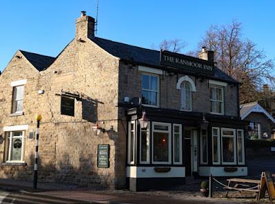
Like my investigation of the historic buildings in Fulwood the previous year, I was interested in the physical characteristics of the various stones used for walls to the houses, boundary walls and gate piers, paving, kerbs and road setts could be seen. The first two buildings that I encountered were the Ranmoor Inn and No. 2 Ranmoor Road, which is the former lodge to Ranmoor Grange.
Both appear on the 1855 map and are less than 400 metres away from the old quarries but, even though their stonework is quite dirty, the general colouration with iron staining, its massive nature and lack of obvious planar bedding looks different to the Crawshaw Sandstone seen in the Sheffield Board Schools, as does the sample of this rock formation that I obtained from Crookes.


No comments:
Post a Comment