Sunday, 27 November 2016

St. John the Baptist - Hooton Roberts


A general view of the church of St. John the Baptist in Hooton Roberts

An exploration of the geology and architecture of Hooton Roberts shows that distinctly red sandstone bedrock occurs very near to St. John the Baptist's church and that boundary walls and the walling to many of the oldest secular buildings are also built in a stone that I would describe as “Rotherham Red” sandstone.

The 15th century tower

A quick walk around the church - set in a small churchyard with steeply falling ground marking its northern boundary - reveals that it is also mainly built out of red sandstone and some mottled yellow varieties, with buff/brown sandstone used in most of the rebuilt chancel, for restored windows and general repairs to the fabric.

A view of the chancel and a neighbouring house

The English Heritage listing describes it as having a 12th century core, with rebuilding in the 15th century and extensive restoration during the Victorian period; rubble masonry is visible in the north side of the nave and chancel and parts of the south aisle, but the tower and later extensions are built with much more precisely squared blocks of sandstone.

The north elevation of the nave

On this occasion, like others that I have visited during my investigation of the building stones and construction history of mediaeval churches in and around South Yorkshire, I was unable to see the interior of St. John the Baptist's church and the remaining Norman arches, because it was locked.

A general view of the south aisle

Saturday, 26 November 2016

Hooton Roberts Village


A view up Holmes Lane

On Holmes Lane in Hooton Roberts, although I did not have a compass clinometer to measure the actual dip of the small outcrops of rock on either side, my observations seemed to suggest that it is in the opposite direction to that seen in the strata to the south of the River Don  - from Rotherham to Denaby - which are affected by the Don Monocline.

A general view of Hooton Roberts

My old paper BGS map marks a fault just to the north-west of this outcrop, with a downthrow in this direction, and it has made me wonder if the map is actually correct; however, without investigating this further, I continued my investigation of the “Hooton Roberts Rock” by surveying some of the old buildings that can be found in this village.

The Earl of Strafford

The Earl of Strafford public house, built around the turn of the 17th century and considerably enlarged in the later part of the 18th century, is the oldest listed building in Hooton Roberts – apart from St. John the Baptist's church – and its walls are built out of “Rotherham Red” sandstone, with the quoins and dressings made from a buff/brown variety of sandstone.

Sandstone dressings at the Earl of Strafford public house

When undertaking a survey of the geological sites in Rotherham for the South Yorkshire RIGS Group, back in 1989, I very briefly visited the Hooton Quarry, which is excavated into a buff/brown variety of Mexborough Rock – 1 km to the west of the village – and this is very likely to be the source of these dressings.

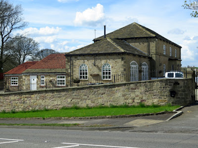
The Coach House

Many of the agricultural and vernacular buildings of a later date are wholly built using this stone but several others use this together withRotherham Red” sandstone, and it also appears in some of the boundary walls that run alongside the main road.

Boundary walling in Hooton Roberts

No evidence of old quarry faces has yet been seen in the village, which would show the extent of the colouration of the rock here, but the abundance of red sandstone - and the need to reduce the cost of transport for stone used for simple vernacular architecture - would suggest that the deep blood red stone used to build houses next St. John the Baptist's church was quarried nearby.

Vernacular architecture in Hooton Roberts