Sunday, 24 February 2019

Manor Top to Manor Lodge – Part 2


A memorial at City Road Cemetery in Sheffield

During the first part of my walk from Manor Top to Manor Lodge, I encountered various sculptures by Tom Clark, Thomas Kenrick and Ben Leach, which had been commissioned by Sheffield City Council in 2009 – as part of the City Road Project. 

Sculptures outside the Gatehouse at Sheffield City Road Cemetery

Walking down from the entrance to Manor Fields Park, there are two more large sculptures in this series – again carved in Crosland Hill sandstone – which flank the entrance to the City Road Cemetery, which has an impressive Grade II listed gatehouse.

Carrara marble and Hopton Wood stone

I had briefly visited the cemetery a couple of times before but I had never been inside the Halls of Remembrance, where I was interested to see that that the niches used to inter the ashes contain inscriptions that are carved into panels of grey veined variety of Carrara marble - known in England as ‘Sicilian’ - and Hopton Wood stone

Various stones used for monuments in City Road Cemetery

Walking up past the crematorium, there are numerous large monuments with obelisksurns, crosses and statues made in various granites and white Carrara marble, which were very popular during the Victorian period, and these provide an opportunity for students at all levels to study the mineralogical and physical characteristics of a wide range of stones. 

The Cross of Sacrifice in City Road Cemetery

Exploring the cemetery further, I came across a war memorial c.1920 designed by Sir Reginald Bromfield. The Commonwealth War Graves Commission style Cross of Sacrifice, together with its accompanying inscribed screen wall, is made out of Portland stone and this monument is protected with Grade II listed status. 

The Belgian war memorial in City Road Cemetery

Making my way quickly to the north entrance, I paused to look at the dilapidated Roman Catholic Mortuary Chapel, which was at last being repaired, and there I noticed another war memorial c.1920 in the form of a calvary – this time in memory of soldiers of the Belgian Army and of the refugees who died in Sheffield during the Great War.

A detail of the calvary at the Belgian war memorial

Arriving at Manor Lodge, I had hoped to take another look around this interesting Tudor ruin – which is situated on high ground formed by sandstone of the Pennine Lower Coal Measures Formation but, I found it closed.

A view of  Manor Lodge from Manor Lane

Making my way down Manor Lane to the Manor Oaks Studios, where I briefly talked to a few of the artists, I carried on to the low ground upon which the Sheffield Parkway has been built, before catching the tram back to Sheffield city centre at Cricket Inn Road. 

A view to the east from Manor Lane in Sheffield

Monday, 18 February 2019

Manor Top to Manor Lodge – Part 1


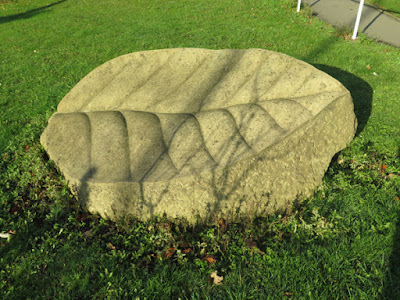
A leaf sculpture at the junction of City Road and Windy House Lane

With the good weather of autumn 2018 finally coming to an end in November, except for a few short walks in Sheffield city centre to look for some public art and sculpture, it was nearly a month since visiting the Upper Don Valley and Sheffield City Hall that I set off to explore some more of Sheffield’s geology and geomorphology again. 

Geology of Britain Viewer 3D map of the area around City Road

Coinciding with a weekend where the venues of Yorkshire Art Space were open to the general public, I took a walk from Manor Top to Manor Lodge via the City Road Cemetery, which coincided with the outcrop of the Parkgate Rock. This sandstone forms very prominent topography to the south of Sheffield, including Skye Edge, and although folded to some extent along its strike, it follows the typical NW–SE direction found in the region and is not generally affected by the Don Monocline

Sculpture by Tom Clark at Manor Top Library

Taking the tram to Manor Top, where I wanted to have a quick look at the architecture of the public library here, I was pleasantly surprised to discover that the area in front of the library had been landscaped and contained at its centre, a sculpture by Tom Clark – one of several produced with Thomas Kenrick and Ben Leach, in Crosland Hill stone, for the City Road Project in 2009. 

Leaf sculptures at the junction of City Road and Windy House Lane

Walking down City Road, three large leaf sculptures by the same artists occupy a small green space at the junction of Windy House Lane and a little further down - on the opposite side of the road – various other sculptures occupy a small patch of waste ground that, unfortunately, is full of litter and appears neglected. 

Stone way markers and sculpture on City Road

Carrying on further down the hill, the entrance to Manor Fields Park caught my eye, with sections of rock faced sandstone walling set at various angles - which seems very appropriate in a region where the strata has been distorted by faults and folding. 

Sandstone walling to the City Road entrance to Manor Fields Park

The various walls are terminated on the City Road frontage by four large rough blocks of blue hearted Ancaster Weatherbed limestone, whose drill marks record the extraction from the quarry face using the traditional technique of plug and feathers

Rough blocks of Ancaster Weatherbed limestone at Manor Fields Park

Having once spent a few months cutting this stone, along with White Mansfield and Chilmark stone, I was particularly interested to see that these blocks also have some pink colouration, which appeared only very occasionally on my saw bench. 

Landscaping with Carboniferous sandstone at Manor Fields Park

Taking a quick look at the park, which once formed a part of the mediaeval deer park that was centred on Manor Lodge, I was interested to see that it has been landscaped with Carboniferous sandstone – using dy stone walling, various boulders and large slabs of stone that are constructed in the form of a tor.

A tor like structure at Manor Fields Park

Friday, 15 February 2019

Sheffield City Hall


The front elevation of Sheffield City Hall

At the end of an afternoon spent exploring the geology and geomorphology of the Upper Don Valley, I finished my day by taking advantage of the late afternoon sunshine that lit up the lobby in Sheffield City Hall

An oblique view of Sheffield City Hall

Designed in 1920 by E. V. Harris, who was also responsible for Leeds Civic Hall, the construction was delayed and the building was eventually completed in 1932, using Darley Dale stone from the Derwent Valley to the north of Matlock. This relatively iron free medium grained sandstone from the Ashover Grit was renowned as a building stone, along with others in the area, and it has stood the test of time well. 

Bomb damage on a portico column

The only repairs visible are to the columns of the portico, where small square indents were inserted after a bomb exploded in Barkers Pool during WWII and blend in well with the original stonework, even after the building was cleaned in the last couple of years. 

The apsed north side of Sheffield City Hall

The neoclassical design of the exterior is quite plain and generally without ornament, with the most unusual feature being to the apsed north side, where a series of pillars with Corinthian capitals rise several feet higher than the wall and carry an entablature

An Ashburton marble door surround

Entering the lobby, it is the polished Ashburton marble panels surrounding the internal doors to the auditorium that catches the eye. This dark grey polished limestone, with pink blotches and fossil sponges is very attractive and was made very popular by Victorian architects, with another fine example of its use being in the nearby Sheffield Town Hall

A detail of Ashburton marble

The walls are lined with panels of alternative light and dark grey Hopton Wood Stone, a Carboniferous limestone from Derbyshire that was again highly desired by architects for interior decoration. It has been used in country houses and other fine historic buildings throughout the UK and, again at Sheffield Town Hall, the walls to the main staircase are in part lined with this. 

Hopton Wood wall panels and black limestone flooring

The floor is paved with very dark grey limestone of unknown provenance, but it is undoubtedly a Carboniferous limestone, with this type of stone historically being supplied from Kilkenny and Galway in the Republic of Ireland and from the Wallonia region in Belgium. 

A stone lion in Sheffield City Hall

One particularly interesting feature in the lobby is the pair of lions, in Derbyshire gritstone, which were originally sited on the main stage. Standing 1.25 m high and weighing 2.5 tonnes each, they are fine examples of stone carving in an Art Deco style by John Hodge.

A detail of a stone lion

Thursday, 7 February 2019

Geology in the Upper Don Valley


A 3D view of the geology in the Upper Don Valley

When studying geology at Nottingham University, an essential part of the training was to learn how to interpret and make geological maps, which for me entailed six weeks exploring the Borrowdale Volcanics, near Derwentwater in the English Lake District

1:50,000 British Geological Maps of South Yorkshire and adjoining areas

Although I was commended for my mapping project, I knew that I wasn’t destined for a career with this and I haven’t used a compass clinometer ever since; however, having subsequently surveyed numerous sites in the Peak District National Park and South Yorkshire – highlighting their conservation, educational and aesthetic value - the printed British Gological Survey maps and accompanying memoirs that I own have been invaluable. 

British Geological Survey Memoirs to accompany 1:50,000 scale maps

Looking at the 1:50,000 scale map of Sheffield, I have often scratched my head when trying to work out the structure of the region, with various faults and folds affecting the Upper Carboniferous strata – especially the Don Monocline, which has tilted the rocks more than 30 degrees in places.

An extract from the old printed 1:50,000 geological map of Sheffield

The rocks here were distorted during a period of mountain building known as the Variscan Orogeny and the precursors to the River Don and four other rivers have cut into them to leave a landscape in Sheffield that has often been described as having seven hills – with distinct valleys in between. 

The Upper Don Valley on the Geology of Britain Map Viewer

Having explored some of the hilly green spaces that are part of the Sheffield Round Walk and, afterwards referring to geological maps of the areas - including the 3D Geology of Britain Viewer - I begun to get a much better appreciation of the structure of the rocks – even though I had encountered very few rock outcrops. 

An outcrop of Greenmoor Rock on Brincliffe Edge

With the very mild and often sunny weather continuing well into the autumn of 2018, I resumed my investigations in the Loxley Valley and around Chelsea Park on Brincliffe Edge – where there are still occasional outcrops of Brincliffe Blue/Greenmoor Rock relating to the former quarrying industry here - and looking on Google Map I decided to visit Crookes Valley Park, which I had noted when working as a geologist at Weston Park Museum

A dry stone wall built on Greenmoor Rock in Mushroom Lane

Starting my walk on Mushroom Lane, the first thing that I noticed was that the boundary wall opposite the museum contained, in its lowermost parts, small outcrops of flaggy Greenmoor Rock upon which the dry stone wall has been built.

A detail of bedrock and dry stone walling on Mushroom Lane

This tiny rock exposure doesn’t provide enough surface area on the bedding planes to take an accurate measurement of the dip and strike of the strata, but the visible inclination of the laminated beds reflects the effects of the Don Monocline – with a dip of 25 degrees to the south-east measured by the British Geological Survey here. 

Rising ground formed by the Loxley Edge Rock in Crookes Valley Park

Mushroom Lane slopes down in a north-easterly direction towards the River Don and, to the north-west, a distinct escarpment drops down into Crookes Valley Park – now filled with a reservoir – with the land rising again along the dip slope of the older Loxley Edge Rock, which again dips more than 25 degrees here. 

A view south-east across Crookes Valley Park to Weston Park Museum

Arriving at Crookes Valley Road, the infilling of the dams that occupied this valley from the 18th-19th century, and the subsequent landscaping to build this road, detract from the natural lie of the land – which includes a sharp change in the topography that coincides with a fault, as I had previously experienced when going to an event in The Ponderosa the year before. 

Crookesmoor Road follows the Grenoside Sandstone down to the River Don

Walking up Crookes Valley Road to the junction with Crookesmoor Road, the relationship between the geomorphology and the geology started to become more obvious – especially when I walked down the long straight road to Upperthorpe, with views over The Ponderosa to my right. 

Views up Blake Street towards Ruskin Park

Having by now orientated myself with the stretch of the River Don that runs from Lady’s Bridge to Hillsborough, I began to find my way to Ruskin Park, a green space that I had identified on Google Map when planning this day out. Winding my way up through a few residential streets, where I unexpectedly encountered Blake Street Nature Park, I then came across Blake Street itself, which – I learned shortly after – is Sheffield’s steepest street

Various views down Blake Street towards Sheffield city centre

The steep slope again is controlled by the structure associated with the Don Monocline and, when walking up the street, the Greenmoor Rock is succeeded by the younger Crawshaw Sandstone. At the top of Blake Street, the topography flattens out, with an inlier of the Rough Rock being exposed at the surface by a fold that plunges east to the River Don, before the strata dips down towards the River Rivelin in the north. 

A view of Parkwood Springs from Ruskin Park

From the vantage point of Ruskin Park, views of the old quarry faces adjacent to the landfill site at Parkwood Springs can be seen on the other side of the Upper Don Valley. Here, the escarpment that comprises mainly Greenmoor Rock has been widely exploited for building stone, ganister for making refractory products and for brick making. 

A detail of an old quarry face at Parkwood Springs

Now the subject of a planned phase of major regeneration by Sheffield City Council, this area contains two Geological Sites of Special Scientific Interest and, from various public paths that cross Parkwood Springs, various points of geological interest are clearly seen. 

A view of Parkwood Springs from Albert Terrace Road

Having spent less than an hour and a half exploring a part of Sheffield that I didn’t know, I finished off my walk at Penistone Road, where I took a few quick photos of the Neepsend Brick Pit SSSI, before heading back to Sheffield city centre on the tram – where I had a quick look around the exterior of Sheffield City Hall.

A view of the Neepsend Brick Pit SSSI from Albert Terrace Road