Returning to the Barnsley Road from Wet Moor Bridge, having had a brief exploration of Wath-upon-Dearne, I started my exploration of West Melton, a former coal mining village that grew rapidly from a small linear settlement that stretched along Melton High Street – as seen on the 1855 Ordnance Survey map.
Passing various stone terraced houses, which were built when the coal mining industry along the Dearne valley grew rapidly in the second half of the C19, the first listed building that I encountered was Nos. 131-133 – a coursed rubble built C18 farmhouse and cottage that has timber elements that are probably late mediaeval in date.
The weathered and slightly blackened surface hides its true colour and textural characteristics, but the underlying bedrock is still the Oaks Rock and it is quite likely that the quarries I had identified at Wath-upon-Dearne would have supplied the stone.
A little further down the road is the barn to the north of Nos. 143-145, which was built no later than the middle of the C18 and again has roof timbers that are dated to the C17 or earlier. The masonry is again weathered, but this time a distinct yellow/orange colouration is visible and consistent with the Oaks Rock.
Moving on to Highfield Farm, a large complex of farm buildings that was built in two phases, the first constituting 4 buildings from c.1750-1773-4 for the 2nd Marquess of Rockingham, with a later building for the Fitzwilliam family between c.1800-1855 - according to Historic England.
I could only get glimpses of the adjacent late C18 Beech House, through the trees from the public footpath and from the churchyard at Christ Church (1855), which was next on my list to photograph for the British Listed Buildings website.
As with most Victorian churches that I have visited, when quickly walking around its exterior, I didn’t notice anything of archaeological interest or take a close look at its blackened stonework but, for future purposes, I have noted that the architect responsible was Pritchett & Son – a practice that I am not familiar with.
I had a wander around the churchyard, which contains a few Portland stone Commonwealth War Graves Commission headstones, but I did not find any new regimental crests. I just took a few record photos of their condition, including the headstone of Private S. Sanderson of the York and Lancaster Regiment, which is a replacement that has been inscribed with a CNC machine.
After taking a few photos of the stonework to the old farm opposite the church and the terrace of cottages next to the churchyard, which exhibit characteristics of colour and texture that I had seen elsewhere in the Oaks Rock.
I stopped briefly to photograph the boundary walling that had been newly built as part of the new housing development on Hayes Walk, where the iron stained sandstone of unknown provenance has some very unusual dark brown/purple colouration, which I thought didn’t look very natural and wondered if it could possibly be spray paint.
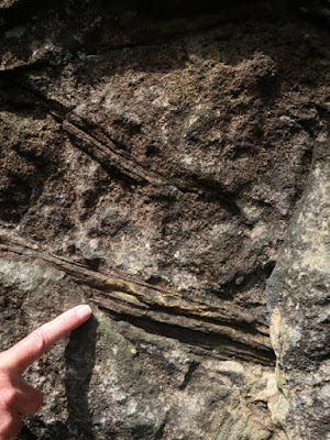
Retracing my steps along the south side of Melton High Street, when looking for the public footpath back to Wath-upon-Dearne, I noticed an outcrop of the Oaks Rock in the drive to No. 155 and, seeing the owner in the garden, I went down to ask permission to take a few photographs.
Although I had my Estwing hammer with me, I just collected a small loose sample, which is yellow/brown in colour, medium grained and contains some degraded iron bearing minerals and possibly feldspar. Returning to Melton High Street and finding the public footpath, I then set off towards my next destination, Newhill Grange.


