Monday, 26 August 2019

Graves Park Revisited


A stream bed exposure of Greenmoor Rock in Graves Park

At the beginning of April 2019, with my friend Paul May, I walked from Meadowhead to Brincliffe Edge to prepare the September field trip for the Sheffield U3A Geology Group

The Greenmoor Rock between Meadowhead and Brincliffe Edge

Whilst there were enough points of interest, over a walk of 7 km, I was concerned that, if the Group wasn’t allowed access to the excellent exposure of Greenmoor Rock behind the Morrisons supermarket at Meadowhead, the timing and location of our lunch break could be problematic – given that the stretch of the walk beyond the Woodseats end of Graves Park was in a built-up area without a convenient stopping place. 

The online Ordnance Survey map of Graves Park

As a contingency, I therefore decided to go and have another look at Graves Park, to see if I could find further exposures of rock along the course of the stream that runs westwards from the series of artificial lakes that occupy the eastern part of the park. 

An exposure of sandstone, siltstone and mudstone

Immediately to the west of the ponds, the stream flows through a steep sided valley, in which are exposed thin bands of sandstone and relatively thick sequences of mudstone that I had not encountered in Cobnar Wood during previous visits. 

A rock exposure in Graves Park

Moving further west the steep sided valley flattens out, with the stream meandering over generally boggy ground that is fed by springs. In the stream bed, small thin outcrops of flaggy sandstone can be frequently seen, as well as mudstone in the stream banks, and I also encountered further examples of yellowish clay. 

Exposures of flaggy sandstone in the stream bed

Taking a detour to investigate the open area of Graves Park to the north, which is now largely occupied by playing fields, I was curious about a couple of linear features that the Friends of Graves Park consider to be lynchets, but which reminded me of a marked geological fault that can be found in Clifton Park in Rotherham.


A linear feature in Graves Park of geological/archaeological interest

This further exploration of Graves Park didn’t add significantly to the variety of rocks that I had previously encountered on the planned route of our walk, however, from an archaeological and historical point of view, I found several interesting features that would provide a backup on the day, should permission to visit the Morrisons site be refused.

A spillway in Graves Park

Thursday, 22 August 2019

An Exploration of Worsbrough Bridge


A detail of the Woolley Edge Rock

On my last visit to Worsbrough, in April 2019, to look at the interior of St. Mary’s church, I had planned to get the bus into Barnsley and have a look at the exhibition at Experience Barnsley but, on the way, I decided to get off and look at the escarpment of Woolley Edge Rock that is formed just to the north of Worsbrough Bridge.

A view up the escarpment of Woolley Edge Rock

This sandstone is one of the most important beds in the Pennines Middle Coal Measures Formation and forms bold escarpments between Barnsley and Wakefield and can be 40 metres thick. It tends to be much coarser than the other Middle Coal Measures sandstones, is strongly cross-bedded and often bears a close resemblance to those formed in the Millstone Grit.

The geology around Worsbrough Bridge

It has been widely quarried as a building stone and used in the restoration of Wakefield Cathedral and has a very distinctive appearance, which leads me to believe that it was used in the barbican of Sandal Castle, St. Helen’s church in Sandal Magna and also the Chantry Chapel of St Mary the Virgin in Wakefield.

St. Thomas and St. James' church

Before I walked up the escarpment, I noticed the church of St. Thomas and St. James on Bank End Road and went to investigate it, as I thought that this Victorian church – built in 1858 by Flockton and Sons - might have used Woolley Edge Rock in its construction.

St. Thomas and St. James' church

A quick look at the fabric of the church reveals that the Carboniferous sandstone used in its walling is unlikely to be the Woolley Edge Rock, which is yellowish in colour and has weathered significantly, but the dressings are built with a medium grained sandstone that is more durable.

The Worsbrough Combined Memorial

In the churchyard, the Worsbrough Combined Memorial at its west entrance is quite an unusual design, made of Scottish Peterhead granite with a sandstone plinth, with several further examples of this granite seen in a variety of other monuments.

The Colliery Explosion Monument

The Colliery Explosion Monument commemorates the death of 143 men and boys at Swaithe Main Colliery on 6th 1875 December and is built of good quality sandstone that retains its sharp profiles and finely carved details.

Delamination of a grave slab

Before leaving the churchyard, I was every interested to see that the surface of one of the simple inscribed grave slabs had delaminated, with a several millimetre thick part of the slab having detached itself in a single piece – an extremely unusual example of a failure in monumental grade stone taken from the Greenmoor Rock and Elland Flags.

An exposure of Woolley Edge Rock on the A61 road

When finally walking up the escarpment to look at the roadside exposures of the Woolley Edge Rock, I could see enough rock to determine that it was a massive cross bedded sandstone, with very thick beds that make it good as a building stone; however, apart from the occasion exposure where a soft lens had been differentially weathered to reveal distinct iron banding, the rock was too dirty to determine its colour.

An exposure of Woolley Edge Rock on the A61 road

Sunday, 18 August 2019

St. Mary Worsbrough - The Interior


A view east along the nave

My long day out in Nottingham provided me with an opportunity to learn some more about its Triassic geology and, in the churches of St. Mary and St. Peter, its building stones but, just a few days later, I was back investigating the Upper Carboniferous sandstones of Barnsley.

A view west along the nave

Having been unable to gain entry to the interior of St. Mary’s church in Worsbrough two weeks earlier, due to delays with my bus, I returned again to find that a funeral had been planned for that day, and so my plans were again disrupted.

The north arcade

The walls of the aisles and the arcades have been plastered, leaving only the columns and arches with exposed stonework to provide clues to the relative dating of the principal structural components in the church.

The south arcade

Pevsner considers that the north arcade is C14, and notices differences from the south arcade, but the church guide suggests that it is C15 – along with additions that I had described in its exterior. Both of the 2 bay arcades are built with octagonal columns and capitals, with wide arches that are barely pointed, and it is only by very closely observing the details of the mouldings etc. that an expert architectural historian can make such a judgement.

A view of the chancel arch from the nave

Moving to the chancel, a close examination of the detailing – especially on the eastern side – shows that the chevrons and other patterns are irregularly arranged, which indicates that the original Norman chancel arch has been rebuilt.

A detail of decoration on the chancel arch

The enlargement of the chancel, with the addition of the St. Catherine’s Chapel and the Lady Chapel, involved the construction of wide nearly round arches as seen in the arcades and on the north wall of the sanctuary, there are two openings – one at low level, which appears to be an altered doorway and another at high level, whose origin and use is unknown.

Miscellaneous openings in the sanctuary

The plastered walls again prevent a better understanding of its standing buildings archaeology but the Norman window in the north wall of the sanctuary, seen only as a narrow slit on the exterior, has a wide splay and the thickness of the stone wall is clearly seen.

The Norman window in the sanctuary

Due to the arrangements there made for the funeral, I was able to enter the vestry, which contains a carved Norman stone that depicts a centaur, however, the doorway to the vestry has a flat headed, four centred ogee arch that is a characteristic of the Tudor period.

The doorway to the vestry

Friday, 16 August 2019

The Nottingham Castle Formation


A detail of the Chester Formation on Newcastle Drive

At the end of a very long day out in Nottingham on the Easter weekend in 2019, I finished my exploration of the city by having a good look at various outcrops of the Lower Triassic sandstone that was known as the Bunter Pebble Beds, and then subsequently renamed as the Nottingham Castle Sandstone Formation and – very confusingly – the Chester Formation

The Chester Formation in central Nottingham

The sandstone was formed by the erosion of the Variscan mountains that lay to the south of what is now Britain 250 million years ago and deposition took place in a huge braided river system that spread across the semi-arid inland basins occupying much of southern, north-western and north-eastern England. 

Castle Rock by the East Midlands Geological Society

Several outcrops of this pale brownish coloured medium grained and poorly cemented sandstone are found around the spectacular Castle Rock, with very many horizons being rich in well-rounded pebbles of red/brown quartzite and white vein quartz

Rock exposures adjacent to The Tunnel

While wandering around The Ropewalk area, which lies near to the western edge of Castle Rock, I was particularly interested to see that many of the houses are built near to the edge of the cliff and back gardens drop steeply to The Park below. Although I couldn’t gain access to it, this includes a house whose rocky foundations adjoin the Park Tunnel, completed in 1855 for the Duke of Newcastle and where fine examples of cross-bedding can be seen. 

An exposure of the Chester Formation on Newcastle Drive

Along Newcastle Drive, a large length of a brick retaining wall covers much of the sandstone but, here, there is a good opportunity to study various sedimentary structures and the wide range in lithology of the various pebbles that are found in the sandstone. Also, one stretch of the rock contains numerous cavities, which reminded me of burrows that are made by sand martins

Sand martin burrows on Newcastle Drive

Continuing with my investigation of the area, I arrived at Lenton Road, which runs below the northern part of the curtain wall to Nottingham Castle - where another extensive exposure of the Chester Formation can be seen.

The Chester Formation on Lenton Road

I didn’t take a close look at this, as I was more interested in the efflorescence at the base of the retaining wall below Royal Standard House, which I assume are related to the high content of soluble of minerals in the sandstone behind it. 

Efflorescence in the retaining wall below Royal Standard House

Walking back up to the top end of Castle Road, I then carried on down past the Robin Hood sculptures on the east side of Castle Rock, where various caverns have been excavated into the rock, and finished my day at Ye Olde Trip to Jerusalem

An exposure of the Chester Formation on Castle Road

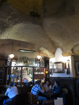
Reputed to be the oldest public house in England, many of its labyrinth of rooms occupy several similar excavations that, along with the nearby Mortimer’s Hole that descends from the castle above and many others under the city, form one of the most interesting features of Nottingham. When having a drink here, it is always advised to place a beer mat on top of the glass – because it stops the constant fall of sand. 

Ye Olde Trip to Jerusalem

On this occasion, having walked several miles and taken more than 700 photographs, I sat outside on an exceptionally warm spring night, put up my feet – which had by now begun to ache – and relaxed with a couple of pints of Abbot Ale, before catching the train back to Sheffield.

A pint of Abbot Ale at Ye Olde Trip to Jerusalem

Wednesday, 14 August 2019

Wollaton Park and Wollaton Hall


The front elevation of Wollaton Hall

During my day out to Nottingham on the Easter weekend of 2019, I spent 4½ hours exploring the Lace Market and the churches of St. Mary and St. Peter and by the time I arrived at the entrance to Wollaton Park on the Derby Road it was 2:45 pm, with Wollaton Hall due to close at 4:00 pm. 

The entrance to Wollaton Park on Derby Road

Wollaton Park occupies the bulk of an outcrop of the Triassic Lenton Sandstone Formation, with Wollaton Hall set on the north-west end of a low but prominent ridge of the younger Chester Formation, which runs south-east to the eastern part of Nottingham University campus. 

A geological map of the area around Wollaton Park

Arriving at Wollaton Hall, I had no time to look at the exterior of this magnificent house built by Robert Smythson for Sir Francis Willoughby and finished in 1588, the year in which the Spanish Armada was defeated. 

The patina on the Ancaster limestone at Wollaton Hall

Taking only a few general photographs of the rear elevation to record the dark honey coloured patina that the Jurassic Ancaster limestone has acquired, as seen earlier in the day on Low Pavement, I then went inside to discover the wonderful three storied hall, which has a finely carved screen on one side. 

A detail of the finely carved screen in the hall

The Natural History Museum is full of wonderful old fashioned cabinets and stuffed animals, which very many museums have now sadly replaced with interactive displays that often break down and can’t be repaired due to budget cuts. 

Fossils
A large proportion of its collection of geological specimens, however, had been temporarily removed as part of the reorganisation of their collections but, nonetheless, I still think that they had some excellent specimens on display. 

Minerals

I could have done with more time to look at the contents of the museum and I was one of the last visitors to leave when it closed but there were still plenty of things to see in Wollaton Park. 

A detail of the old stable block

Although the Nottingham Industrial Museum housed in the stable block had also closed for the day, I had a very welcome cup of coffee at the Café in the Courtyard, where I particularly appreciated the photographs of specimens from the museum’s geology collection, which covered one of the halls. 

A display of photographs of geological specimens 

Up until then, I had spent 6½ hours exploring parts of the city that I had never bothered to visit when I was student there and I was glad to relax for a while in the late afternoon sunshine, before taking a quick look at the memorial to the American 508th Parachute Infantry Regiment and then heading back to the city centre, where I finished my day by looking at the geology of Castle Rock.

The 508th Parachute Infantry Regiment memorial

Tuesday, 13 August 2019

St. Peter's Church - The Interior


A view east along the nave

When exploring the exterior of St. Peter’s church in Nottingham city centre, I took good note of the various stones that have been used in its fabric over the years but, once inside, the remnants of a lime based covering had obscured the stonework to the extent that I really didn’t notice the stone itself; however, looking closely at the photographs, yellow to red colour tones can be distinguished in the sandstone. 

A view west along the nave

Looking mostly at the structure instead, both of the walls to the south and north aisles are plastered and painted, as is the Victorian chancel, and it is only the walls at each end of the nave, with their respective arches, and the arcades that have exposed stonework. 

The south arcade

The 5 bay south arcade dates to the C13 and is constructed with arches that are Early English in style, but is quite unusual in that the second and third arches from the west end are separated by a small section of wall and not a column. On the plan of the church by the architect D.A. Marshall, this is marked as having a C12 core and the oldest part of the original church, which was destroyed by the Empress Matilda in 1140. 

A capital with stiff leaf carving

Some of the capitals are ornamented with stiff leaf carvings, which is a feature of the Early English style, and there are several carved heads; however, many of these intricate carvings have lost their detail and, judging by their sharp profiles, some of the heads may be replicas. 

A change in the style of masonry above the south arcade

Looking at the masonry above the south arcade, although the colours of the stone can barely be seen, the change in the shape and size of the blocks shows that there has been a phase of rebuilding, which includes the C15 clerestory – where the window tracery is in a late Perpendicular Gothic style. 

The north arcade

Turning around to examine the C14 north arcade, where the columns are much taller, the capitals were modified in 1495 with a castellated design and, having been damaged during the English Civil Wars in 1644, the clerestory was renewed in 1699 with very simple windows. 

An old roof line above the tower arch

At the west end of the nave, the C15 tower has a very tall arch and above this there is a very distinct old roof line, which clearly shows the very asymmetrical design of the nave, with the north aisle being constructed inside the old wall instead of the outside, which is the usual practice. 

Wall memorials in the chancel

In the north aisle and the chancel, there are numerous wall memorials that are made of a wide variety of decorative stones, with elaborate monuments to the Locke family, and there are also several war memorials – including the St. James’ war memorial, which I particularly liked.

The St. James' war memorial