Thursday, 30 November 2023

A Walk Along the Rivelin Valley

 
An outcrop of the Middle Band Rock and underlying mudstone

With no opportunities to explore any quarry exposures at Bell Hagg and Crosspool, it had only taken just over an hour to walk from Redmires Road down to Roscoe Bridge, an early C19 road bridge spanning the River Rivelin that I wanted to photograph for the British Listed Buildings website Photo Challenge. 
 
Roscoe Bridge
 
I went to have a quick look at various remains of the Roscoe Wheel (1725), which include the stone built wheel-pit and arch. The mill was mainly used for the fender and saw grinding trade, for which huge grindstones exceeding 2 metres in diameter were required, but it was derelict by 1936 and the various buildings, including cottages, have long since disappeared. 
 
The wheel-pit at Roscoe Wheel

A little further downstream, I passed the Rivelin Chair sculpture by Jason Thomson, but on this occasion I was more interested in the outcrop of Crawshaw Sandstone forms a small cliff on the north side of the river, which appears to have been excavated for some reason but now has a sturdy iron grill covering the entrance. 
 
A cliff formed by the Crawshaw Sandstone

The section here comprises mainly thin bedded, rather flaggy sandstone with some slightly thicker massive beds but there are no obvious physical characteristics that make it stand out against the other Pennine Coal Measures Group sandstones in the region. 

A detail of the Crawshaw Sandstone cliff

Continuing past Rivelin Park Cafe, I returned to the river bank to take a look at the weir that formed part of Hollins Bridge Mill (1724), which was originally used for grinding cutlery but, at a later date, it ground optical lenses for use in telescopes and glasses, with it subsequently being converted into a corn mill in 1868. 
 
The weir at Hollins Bridge Mill
 
Following the path on the west side of the river, I took a diversion down to the river bank at Hollins Bridge. Although I don’t know its purpose, there are the remains of part of a wall that runs along the streambed a couple of metres out from the west bank. 
 
The river at Hollins Bridge

Crossing Hollins Lane and continuing along the path a few metres above the level of the river, just before the path dropped down to the stepping stones, I noticed a small outcrop of what I later discovered is the Middle Band Rock. 
 
A small outcrop of the Middle Band Rock

Although I had passed over this formation when exploring the historic architecture of Stannington, I did not have this in my rock collection. The samples that I took with my Estwing hammer are a light brown/grey very fine grained sandstone, with carbonaceous inclusions and occasional specks of muscovite mica. 
 
Specimens of Middle Band Rock
 
The path then drops down to a meander in the river, which has eroded the strata on its west bank to form a small cliff. Large squared blocks of stone form a path down to the river, which continue as stepping stones, with a ramp for vehicles next to it. 
 
The approach to the stepping stones

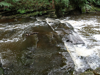
Crossing the stepping stones, I took a few record photographs of the rock exposure, which consists of a section of Middle Band Rock that is underlain by darker Pennine Lower Coal Measures Formation mudstones, with the latter having been eroded by the river to leave a overhang. 
 
An outcrop of the Middle Band Rock and underlying mudstone

I had a quick wander around Walkley Bank Tilt (c.1751), which was originally a cutlers’ wheel but was converted into a tilt forge and later a wire-drawing mill. The dam still exists, but all of the buildings have long since disappeared, with just a small bridge and stone built infrastructure of unknown purpose remaining. 
 
Views around Walkley Bank Tilt

Making my way further downstream, I could only catch glimpses of the buildings at Mousehole Forge, which dates back to at least 1628. The forge is now a private property and I could only see parts of it through the main gates and over boundary walls. 
 
Views of Mousehole Forge
 
I finished my walk along the Rivelin Valley by having a quick look at the weir at Grogram Wheel and was surprised to to see that the banks and the island in the river downstream are made up of iron slag, which was tipped into the river by the occupants of the Mousehole Forge. 
 
Deposits of iron slag at Grogram Wheel

The iron slag is in part very dense and rust coloured, but it also has blackened parts that are full of air bubbles and look like crozzle, which I had seen used to top boundary walls at various place in Sheffield. The slag is surprisingly hard and, with no obvious projections from its surface, it was not that easy to break off a sample with my hammer. 
 
Specimens of iron slag from Grogram Wheel
 
Arriving at Malin Bridge, I took advantage of the Lidl supermarket to do some essential shopping, before taking a few photographs of the sculpture by Steve Roche, which depicts some of the items that were included in insurance claims after the Great Sheffield Flood in 1864. 
 
The Sheffield Flood sculpture by Steve Roche at Malin Bridge

Geology at Bell Hagg and Crosspool

 
An outcrop of Chatsworth Grit on the Manchester Road

After my field trip at Hunshelf with the Sheffield U3A Geology Group, which was marred somewhat by the excessive numbers and a few stragglers who were not really fit to do the walk, my next day out involved a walk from the Hallamshire Golf Course to Malin Bridge.
 
The geology around the Rivelin Valley

The aim of the day was to visit two old quarries in the Crosspool area of Sheffield: The large Bell Hagg Quarry on Manchester Road, which once extracted the Chatsworth Grit, and the Marsh Lane Quarry, where stone was taken from the Redmires Flags Sandstone. 
 
A snicket alongside the Hallamshire Golf Course
 
Alighting from the No. 51 bus at the Redmires Road/Pitchford Lane stop, I took the public footpath that directly crosses the golf course and eventually entered a stone walled snicket, which led me around the western edge of the Sandygate Park housing estate to the crags at the southern side of the Rivelin Valley. 
 
A panoramic view across the Rivelin Valley

I just took a few photos of the panoramic view across the Rivelin Valley and some slipped blocks that were partially hidden by the trees, before making my way to the footpath that runs quite precariously along the top of the escarpment.
 
Slipped blocks of Chatsworth Grit

The Chatsworth Grit crags are not as well developed as the gritstone edges in the Peak District National Park but, amid the trees, large slumped blocks can be seen and although I didn’t knowingly see it at the time, there is a large stone known locally as the Rocking Rock, which is said to move in high winds.

The slope beneath the escarpment of Chatsworth Grit

Heading east towards Bell Hagg, the topography comprises a steeply sloping soil covered hillside, with a few rock exposures poking out of it, but well defined vertical faces are not a general characteristic, although these do appear on the approach to the site of the Bell Hagg Quarry. 
 
Chatsworth Grit crags at Bell Hagg

I carried on along the path above the crags until I came to a steep set of wooden steps, which I descended very slowly but a young couple in their mid 20’s just took in their stride, as they ran down them at a fair pace. 
 
The steps from Bell Hagg to Manchester Road

At the foot of the escarpment, I walked a short distance to the Valleyside Garden Centre, which now occupies the old Bell Hagg Quarry, but the old quarry face was fenced off and had become very overgrown by trees, with only distant views of the massive Chatsworth Grit being available. 
 
A face of the Bell Hagg quarry in the Valleyside Garden Centre
 
Returning to the Manchester Road, I continued towards Crosspool and stopped to look at a few outcrops of massive Chatsworth Grit that can be seen on the south side of the road , before making my way down through the housing estate to Stephen Hill. 
 
An outcrop of Chatsworth Grit on Manchester Road
 
The Marsh Lane Quarry is marked as being within the plantation at Clough Fields, with the LIDAR map appearing to show some remaining quarry faces; however, despite having a wander around the site, I could not see any rock exposures. 
 
The site of Marsh Lane Quarry in Clough Fields

At the east side of the site, there is an old dry stone wall that I presume has been built in the stone from the quarry. I obtained small samples of light brown sandstone with my Estwing hammer, which are very fine/fine grained with marked orange iron banding and muscovite mica scattered throughout the body of the stone. 
 
Specimens of Redmires Flags Sandstone from Marsh Lane Quarry
 

Tuesday, 28 November 2023

A Geology Field Trip at Hunshelf

 
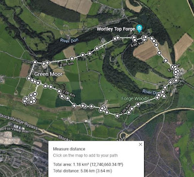
A walk around Hunshelf Bank and Green Moor.

In the latter part of June 2022, I had accompanied Barry Tylee on his recce of the area around Hunshelf, on the Sheffield/Barnsley boundary, for the August Sheffield U3A Geology Group and a few days after my visit to to the Yorkshire Natural History Museum, we set off on our field trip. 
 
At the site of the former Wortley railway station

19 of us met up at the Cote Green car park and, once various preliminaries had been sorted, we set off to our first stop – the old Wortley railway station – where Barry explained the importance of the railway to the quarrying industry in Green Moor and other industries in the area. 
 
Stepping stones on the River Don
 
Although Barry and I had crossed the River Don by the footbridge on our recce, several members chose to use the stepping stones instead, which are marked on the 1855 Ordnance Survey as a ford. We then traced our way down the path to the riverbank, where there are the remains of industrial infrastructure and some excellent exposures of the Greenmoor Rock. 
 
Rocky exposures on the River Don
 
The downside of a very large turnout of 19 members, on this occasion, was the need to spread out along a riverside path where there are no places the group to squeeze together to listen to the group leader. With Barry near to one end of the line of people – talking about the industrial archaeology - and me near to the other end to explain the geology, I am sure that only half of the group got to hear both sides of the story. 
 
Rocky exposures on the River Don
 
We continued our walk by ascending up the path through Tin Mill Rocher, seeing a few rock exposures at a high level and beyond our means of exploration. With a moderately steep ascent of a hundred metres in altitude to undertake, there was a noticeable lag between the time of the leader and the last group member arriving at our next stop - at the western end of Hunshelf Bank. 
 
A view at Tin Mill Rocher

All along its outcrop of from Green Moor to Graves Park, the Greenmoor Rock has been extensively quarried to supply the dry stone walls along the length of the escarpment, which can be quite an art – as we had seen on the previous trip to Green Moor in 2017. 
 
A dry stone wall made of Greenmoor Rock

There are a few places here where the small delves can be clearly be seen and easily explored, yet Barry had for some reason walked straight past them, which we later discovered was because he had been feeling unwell and that he had forgotten about the geology. 
 
A small delf in the Greenmoor Rock
 
Some of us stopped to have a quick look at the very irregularly bedded flaggy sandstone here, which is perfectly suited to dry stone walling but not for producing top quality paving stone, which once came from the thicker beds of Greenmoor Rock that overly them. 
 
The path down to the Green Moor Delf RIGS
 
Following Barry to the site of the RIGS in Green Moor Delf, a remnant of the quarry face at the southern end of the large elongate quarry that once existed here. Having undertaken a few visits to this site, since an initial geological survey of Green Moor as part of the Stoneway Manor housing development, I pointed out various sedimentary structures that can be seen here. 
 
Lunch at Hunshelf Bank
 
We then headed back to Hunshelf Bank, passing the cricket ground and the Isle of Skye Quarry, before sitting down for our lunch at the top of the escarpment, which overlooks Stocksbridge and has great views of the moorland in the distance. 
 
The old pump house
 
Barry formally announced that he had to get back to the centre of Green Moor to open up toilets for our group, so we gathered together at our leisure after lunch and eventually reconvened at the old pump house by the entrance to the Stoneway Manor estate. After explaining its history to the group, Barry took his leave and left myself and Catherine, an archaeologist friend of his and a new member of the group to lead us back to our starting point. 
 
A commemmorative plaque
 
With several members of the group clearly afflicted by some injury or ailment, we decided not to go and explore the old quarries that overlook the south bank of the River Don. Instead, we walked down Well Hill to an old quarry in the Grenoside Sandstone, but the business there was about to close; however, with the owner recognising me from the recce with Barry, we managed to have a quick look at the geology before making our way back to the cars.
 
A quarry in the Grenoside Sandstone


Monday, 27 November 2023

Fossils and Dinosaurs in Sheffield

 
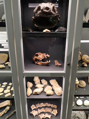
An ichthyosaur skull at the Yorkshire Natural History Museum

My exploration of the geology and architecture around Moorgate and Whiston, in Rotherham, turned into a good 8 km walk, but my next day out the following Saturday - which ended up having a palaeontological theme – was much more leisurely, starting with a trip to Malin Bridge in Sheffield on the Supertram. 
 
A sign at the Yorkshire Natural History Museum
 
Sometime during the summer, I had read something about a new museum opening in Sheffield, without thinking too much about it; however, on Friday 12th August, I woke up to an interview on BBC Radio 4 when James Hogg – founder of the Yorkshire Natural History Museum - was discussing its grand opening the next day.
 
The Yorkshire Natural History Museum

Alighting from the tram at Hillsborough, I walked up Holme Lane to discover that a reasonable queue of adults and children had formed in anticipation of the doors being opened to the public at 11:00 am. Finally entering and paying my fee, I immediately took a liking to the dinosaur wallpaper used for the decoration.
 
Dinosaur wallpaper at the Yorkshire Natural History Museum

As a child, I had a fascination for dinosaurs and was a frequent visitor to the Natural History Museum but, when studying geology at Nottingham University, I wasn’t particularly inspired by the palaeontology lecturers; however, being once deeply involved in geological conservation in South Yorkshire and having worked with Sheffield and Rotherham Museums, where I had seen the decline of their geological displays, I was keen to give my support. 
 
The main gallery
 
Entering the gallery on the first floor, one wall comprises a showcase that is crammed full of fossils of all types and sizes that James has mainly collected himself over the years, along with a variety of decent sized mineral specimens. 
 
Various specimens in the wall display
 
The gallery also includes a handful of freestanding display cases that contain large fossils of ichthyosaurs, a plesiosaur and ammonites on loan, which are very impressive and as good as those that I have seen in many regional museums. 
 
In very many respects this ambitious project is work in progress, with lessons in labelling and classification still to be learned from museums that have long established palaeontological displays; however, given that James’ background as a recent student in Economics and Economic History at The London School of Economics, without any background in the Earth Sciences, the subsequent progress made by him and his colleagues – with great plans for expansion in the future - has been quite remarkable. 
 
Various specimens on display
 
With visitors on the day far exceeding expectations, I just took a few quick photos and returned on the tram to Sheffield city centre, where I was surprised to see several sizeable model dinosaurs made out of LEGO in the Millennium Gallery. 
 
A pteranodon

As part of the Sheffield Bricktropolis, a trail of 15 brickosaurs had been laid out in various shops and public venues throughout the city centre. The previous year, I had taken the train to Leeds especially to see the full sized animatronic dinosaurs, but I had not seen any publicity of any kind for this trail in Sheffield. 
 
A velociraptor

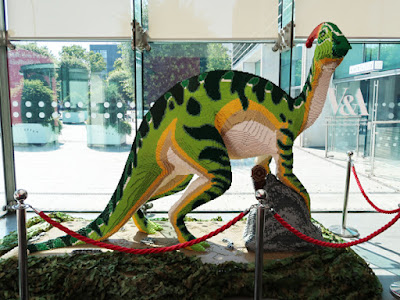
Having loaded up with shopping before returning to Sheffield from Malin Bridge, I was not in a position to go searching for the brickosaurs and had to be content with just seeing the pteranodon, two velociraptors and a parasaurolophus. 
 
A parasaurolophus