 |
| A view over the escarpment at Loxley Edge |
After my trip to Ecclesall Woods on 24th November 2021, to look at the Neolithic rock art and the ganister quarry in Wood 1, I started to undertake a little bit of further research into the quarrying and mining of ganister - a hard, fine-grained quartzose sandstone that was once used in the manufacture of silica bricks to line the steel furnaces in Sheffield.
Having discovered that there was a concentration of mining at Wadsley and Loxley Commons, it gave me the idea to go and have a look at the escarpment formed at Loxley Edge, the type locality for the Loxley Edge Rock, which I only knew from my observations of the building stones around Malin Bridge and Wadsley and also the Sheffield Royal Infirmary.
It had been more than 2 weeks since I last ventured out and so I made the most of a fine day in February to go and have a quick look. Alighting from the No. 57a bus from Sheffield city centre at the Worrall Road/Dykewood Drive stop, I made my way down to the car park on Rural Lane and followed the path along the north side of the old Wadsley quarries, which are now just piles of heather covered waste rock.
I was very surprised to discover that boundary walls or substantial parts of them could be seen everywhere and in one place there I encountered a set of steps that form quite a feature in an area of land that, when looking at old maps, seems to have had no obvious use.
Coming to open common land, I followed the path down to the concrete trig point - at a height of 234 metres and standing a few metres away from Loxley Edge. This is a conspicuous escarpment in the Loxley Edge Rock, which forms a long dip slope south-eastwards from Loxley Common.
Along the gritstone edges of Derbyshire and the Rivelin Valley in Sheffield, the Chatsworth Grit forms distinct vertical rock faces, with the very wide jointing pattern producing very large blocks. In several places along the edges, very large blocks are slowly detaching themselves from the main body of rock and will eventually slide down to the lower slopes and add to the deposit of head.
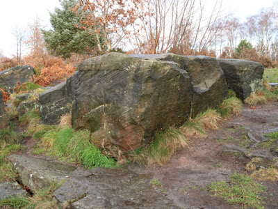
At Loxley Edge, I couldn’t see any obvious vertical rock faces and the pattern of jointing is much more narrowly spaced, with the resultant blocks of stone being substantially smaller. The undercutting and destabilisation of the underlying softer strata, together with cambering and solifluction during the Quaternary Period has led to the formation of a blockfield that falls down to the River Loxley.
Looking away from the escarpment across Loxley Common, the heather covered landscape is littered with small blocks of stone that poke out of the soil but, again, it has quite a different character to gritstone moors that I have seen out in Derbyshire.
Continuing westward, the path closely follows the crags, but there is probably no more than a 150 metre stretch where there is continual rock outcrop, with some of the exposures along this length having been been quarried in the past - as seen on the 1855 Ordnance Survey map.
I didn’t spend much time wandering around this quite spectacular rock outcrop and just took a few record photographs to note the general physical characteristics of the Loxley Edge Rock here - including its massive coarse grained beds, well defined cross-bedding and good examples of differentially weathered graded beds.
The geological memoir describes the Loxley Edge Rock as being yellow and a rather coarse sandstone, which one of my samples confirm, but the other two samples that I also discretely obtained with my Estwing hammer are different shades of brown.
During my very limited investigation of the rock, I didn’t see the flaggy partings that are also mentioned in the memoir but, in one of the massive blocks of cross-bedded sandstone, I noted alternating brown and distinctly reddened beds of sandstone, which I don’t recollect having seen before in my travels around South Yorkshire.
It had only taken me 25 minutes to walk from the car park on Rural Lane to the Long Lane car park - including a good look at the easily accessible exposures of the Loxley Edge Rock. With plenty of time on my hands, rather than retrace my steps, I decided to follow the public footpath that skirts the wooded slopes beneath the escarpment.
The 1905 Ordnance Survey map shows several ganister pits in the area, but I couldn’t see any evidence of these when walking along the path down to the Robin Hood Nature Trail, where I found a large upright stone carved with the cross.
I came across this by chance and can’t find out much about this place, which also contains a circular dry stone wall composed of a few rough courses - presumably once supporting a much taller structure - but a standing buildings archaeologist would probably know more than me.


No comments:
Post a Comment